Last month of 2022! Bring on a little more rain.


Last month of 2022! Bring on a little more rain.


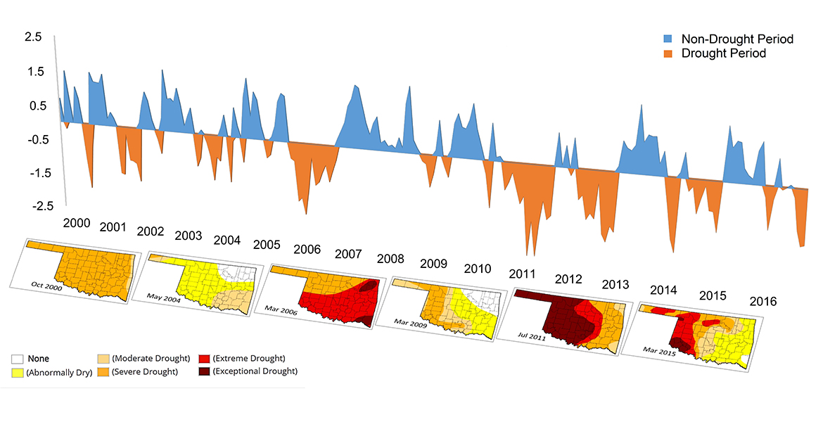
Central OK is about 6-7" under normal for the year. 2022 OKC is on pace for top 30 driest years on record.
Right now it looks like some rain chances with moisture feeding in from the SW Saturday into Sunday. Usually this moisture feed precedes a storm pattern favorable for winter storms across the Plains.
Outside of a pocket around Sequoyah County the entire state is below-normal for the year with historically low annual totals across northern OK. Case in point, the Arkansas River through Tulsa has been mostly dry for the past several months. Entering the driest months December-February I don't expect these numbers to improve significantly but remain hopeful for a wet spring. A wet spring has followed the last few major droughts.


We're 3 years into a La Nina cycle. That's been a big driver of the drought, not only in Oklahoma, but across a good swath of the country. We might break out of La Nina late winter or in the spring. We may even go into an El Nino. That should help feed a lot better rainfall for the country. The 2011/2012 heat waves and drought were also fed by a La Nina.
Yes this is very similar to the La Nina in 2011-12 which typically means lower rainfall/drought for the southwest and central regions. We should be getting into a wetter period as early as next year possibly later in '23. Typically El Nino brings more severe t-storms/tornadoes to the state


Feed from the SW part of the country continues this week. Another storm will ride along this flow and bring rain chances Wednesday into Thursday.


Every single one of these storms is off 50 miles from being a drought-buster. Alas.


NAM coming in with a substantial adjustment in track forecast which would roughly put I-44 corridor under the training storms.

That’s more like it! Hope it pans out
Mike Morgan has Stillwater among the heaviest in the state with 2.3". I'll believe it when I see it.


Amounts fresh off the press.


East OKC metro up I-44 to Tulsa metro, south to DFW and east into Arkansas are currently in a Day 6 (Monday) 15% Risk area, potentially for tornados. Day 7 moves the risk mostly over Arkansas, east Texas, and the north half of Louisiana.
Weather service sure is being conservative about OKC rain totals. Basically suggesting an inch.


^NWS has OKC in the 1.5 swath with localized 2" areas. This is as of about 3pm.
The idea is that more lift will enter the region when the low comes across the area. This should result in some convective precipitation, which is currently forecast to most likely be along and just S of I-44.


I would say current radar trend is favoring the heaviest stuff further south of I-44. Lawton to S Norman area.


The active weather pattern continues. As long as we have this SW flow, we will keep storm chances.
Saturday: Another shot at some decent rain early Saturday morning. Best chances across NE OK.
Monday: SPC has expanded the region of 15% probability of severe weather basically for I-44 and points E. It also looks like Tuesday could be big time severe weather across the Dixie Alley.
Crazy fog this morning!
Ton of rain in Norman last night. Very foggy this morning but decent temp.


Definitely not close to draught busting moisture but still steps in the right direction. I hope the rainfall amounts help the wheat farmers.

What's a source for local rainfall totals per 24 hr period and for weekly, monthly, etc?


There are currently 1 users browsing this thread. (0 members and 1 guests)
Bookmarks