Mesoscale Discussion 1668
NWS Storm Prediction Center Norman OK
0351 PM CST Fri Nov 30 2018
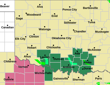
Areas affected...portions of north-central tx into central ok
Concerning...Severe potential...Watch likely
Valid 302151Z - 302315Z
Probability of Watch Issuance...80 percent
SUMMARY...Severe threat will increase after 23z from portions of
north-central TX into central OK. Large hail is likely with this
activity along with some tornado threat. WW will likely be issued by
00z.
DISCUSSION...Leading edge of large-scale ascent is spreading east
across the southern High Plains at roughly 30kt. Latest visible
satellite imagery supports this with blowing dust and strong
westerly surface flow approaching southwest OK. Strengthening
mid-level height falls, on the order of 150-210m, during the latter
half of the period are inducing a focused low-level response across
the Red River valley into central OK. Modified Gulf air mass has now
spread into all but extreme southwest OK with mid 50s surface dew
points now into Jackson County. Over the next few hours, near 60 dew
points are expected to advance into central OK. Given the
aforementioned speed of approaching large-scale forcing, latest
thinking is deep convection should develop by 23z over southwest OK,
perhaps extending south of the Red River into northwest TX. Very
strong shear and steep mid-level lapse rates will support supercell
development by early evening. Large hail is expected with this
initial activity. As convection spreads toward the I-35 corridor a
bit more moist profiles will become more supportive of potential
tornadic development, especially where lower-mid 60s dew points are
encountered. Back edge of severe convection should shift east of
I-35 by 03z.
..Darrow/Hart.. 11/30/2018


 Reply With Quote


Bookmarks