Widgets Magazine
Results 1 to 7 of 7

Thread: 2012 Oklahoma Tornado Tracking List

  1. Weather 2012 Oklahoma Tornado Tracking List

    This thread will be used to track tornadoes that are reported in Oklahoma. This is not meant for severe weather event discussion but as a quick reference list to view data and photos (if available) of tornadoes in Oklahoma for the year. If you are wanting to discuss the severe weather events please check out the monthly discussion threads!

    Google Map of Locations: http://maps.google.com/maps/ms?msid=...rce=gplus-ogsb

    2012 Tornado List from NWS Norman: http://www.srh.noaa.gov/oun/?n=tornadodata-ok-2012

    Monthly/Annual Totals & Averages: http://www.srh.noaa.gov/oun/?n=torna...-monthlyannual

  2. Default Re: 2012 Oklahoma Tornado Tracking List


    Time Location County State Lat Lon Comments
    2350 10 W MANGUM GREER OK 3488 9968 TIME AND LOCATION APPROXIMATE (OUN)
    2354 8 NW MANGUM GREER OK 3496 9960 TIME AND LOCATION APPROXIMATE (OUN)
    0027 3 WNW WILLOW GREER OK 3507 9956 TIME AND LOCATION APPROXIMATE (OUN)
    0037 5 NW WILLOW GREER OK 3510 9957 TIME AND LOCATION APPROXIMATE (OUN)

    Tornado
    Number
    Date Time
    (CST)
    Length
    of Path
    (miles)
    Width
    of Path
    (yards)
    F-Scale Killed Injured County Location
    1 03/18/2012 1850-1857+ EF0 Greer 2 E - 5 NE Reed and continuing
    2 03/18/2012 1910 EF0 Greer 3 WSW Brinkman
    3 03/18/2012 1927-1929 EF0 Greer (3 WNW Willow)
    4 03/18/2012 1937-1942 EF0 Beckham (~5 NW Willow)

  3. Default Re: 2012 Oklahoma Tornado Tracking List


    Time Location County State Lat Lon Comments
    2224 3 SSW WOODWARD WOODWARD OK 3639 9941 THE TORNADO LASTED FOR LESS THAN A MINUTE AND HAS LIFTED. (OUN)
    2252 3 E SHARON WOODWARD OK 3628 9928 MULTIPLE STORM CHASERS, LOCAL BROADCAST MEDIA, AND THE WOODWARD COUNTY EMERGENCY MANAGEMENT REPORTED A TORNADO EAST OF SHARON. THE TORNADO DEVELOPED TO THE EAST-NORTHEA (OUN)

    http://www.srh.noaa.gov/oun/?n=event...09-stormphotos

    Photographs of the brief tornadoes that occurred near and south of Woodward, OK on April 9 as shown on the NWS Norman website.


    Photo Courtesy of Edwina Zumwalt Photo Courtesy of Shannon Wickware
    Photo Courtesy of Brett Wright

  4. Default Re: 2012 Oklahoma Tornado Tracking List


    Time Location County State Lat Lon Comments
    2224 3 SSW WOODWARD WOODWARD OK 3639 9941 THE TORNADO LASTED FOR LESS THAN A MINUTE AND HAS LIFTED. (OUN)
    2252 3 E SHARON WOODWARD OK 3628 9928 MULTIPLE STORM CHASERS, LOCAL BROADCAST MEDIA, AND THE WOODWARD COUNTY EMERGENCY MANAGEMENT REPORTED A TORNADO EAST OF SHARON. THE TORNADO DEVELOPED TO THE EAST-NORTHEA (OUN)

    http://www.srh.noaa.gov/oun/?n=event...09-stormphotos

    Photographs of the brief tornadoes that occurred near and south of Woodward, OK on April 9 as shown on the NWS Norman website.


    Photo Courtesy of Edwina Zumwalt Photo Courtesy of Shannon Wickware
    Photo Courtesy of Brett Wright

  5. Default Re: 2012 Oklahoma Tornado Tracking List

    Below is some of the latest information from the tornadoes last week. The Google Map in the first post is being updated as they continue to update the survey results.

    NOUS44 KOUN 162142 CCA
    PNSOUN
    PUBLIC INFORMATION STATEMENT
    NATIONAL WEATHER SERVICE NORMAN OK
    441 PM CDT MON APR 16 2012...CORRECTED MAX WIND SPEED


    ...PRELIMINARY STORM INFORMATION FOR THE WOODWARD OKLAHOMA TORNADO...


    BEGINNING TIME: ~1150 PM
    ENDING TIME: ~1227 AM
    BEGINNING LOCATION: 2 NE ARNETT (ELLIS COUNTY)
    ENDING LOCATION: 4 NORTH OF WOODWARD (WOODWARD COUNTY)
    FATALITIES: 6
    INJURIES: 29
    EF-SCALE RATING: EF-3 ( MAX WIND SPEED 136-165 MPH )


    THE TORNADO DEVELOPED APPROXIMATELY 3 MILES NORTHEAST OF ARNETT AND
    MOVED NORTHEAST. SIX STRUCTURES WERE DAMAGED AS THE TORNADO MOVED
    TOWARD THE WOODWARD COUNTY LINE. ONLY MINOR DAMAGE... DOWNED TREES
    AND POWER POLES/LINES... WAS SEEN AS THE TORNADO MOVED OVER MAINLY
    RURAL PORTIONS OF WOODWARD COUNTY. AT APPROXIMATELY 1212 AM... THE
    TORNADO STRUCK TWO MOBILE HOMES 5 MILES SOUTHWEST OF WOODWARD. THE
    DAMAGE HERE WAS DETERMINED TO BE EF-2 IN INTENSITY... WHICH ALSO
    RESULTED IN 3 FATALITIES. THE HEAVIEST DAMAGE... RATED EF-3... WAS
    REPORTED AS THE TORNADO ENTERED THE SOUTHWEST SIDES OF WOODWARD
    AROUND 1218 AM. SEVERAL HOME AND BUSINESSES WERE HEAVILY DAMAGED AS
    THE TORNADO CONTINUED NORTHEAST. SEVERAL MORE MOBILE HOMES WERE
    DESTROYED ON THE NORTH SIDE OF WOODWARD... WHICH RESULTED IN 3
    ADDITIONAL FATALITIES. THE TORNADO FINALLY EXITED THE CITY OF
    WOODWARD AT APPROXIMATELY 1223 AM... EVENTUALLY DISSIPATING
    APPROXIMATELY 4 MILES NORTH OF WOODWARD AT 1227 AM.


    THIS TORNADO INFORMATION SHOULD STILL BE CONSIDERED PRELIMINARY AS
    WE CONTINUE TO LOOK OVER INFORMATION.

    PRELIMINARY LOCAL STORM REPORT...SUMMARY
    NATIONAL WEATHER SERVICE NORMAN OK
    106 PM CDT TUE APR 17 2012


    ..TIME... ...EVENT... ...CITY LOCATION... ...LAT.LON...
    ..DATE... ....MAG.... ..COUNTY LOCATION..ST.. ...SOURCE....
    ..REMARKS..

    0359 PM TORNADO 9 N WOODWARD 36.56N 99.39W
    04/14/2012 WOODWARD OK TRAINED SPOTTER


    BRIEF TOUCHDOWN NEAR WOODWARD/HARPER COUNTY LINE

    0430 PM TORNADO 4 NW FREEDOM 36.81N 99.16W
    04/14/2012 WOODS OK BROADCAST MEDIA


    BRIEF TOUCHDOWN REPORTED BY KWTV-9.


    0516 PM TORNADO 11 S TANGIER 36.26N 99.53W
    04/14/2012 WOODWARD OK CO-OP OBSERVER


    BRIEF TOUCHDOWN


    0650 PM TORNADO 4 S QUINLAN 36.40N 99.05W
    04/14/2012 WOODWARD OK TRAINED SPOTTER


    RELAYED BY WOODWARD COUNTY EM


    0708 PM TORNADO 8 S WAYNOKA 36.47N 98.88W
    04/14/2012 MAJOR OK BROADCAST MEDIA


    0712 PM TORNADO 6 SSE WAYNOKA 36.50N 98.84W
    04/14/2012 WOODS OK STORM CHASER


    BRIEF TORNADO OCCURRED SIMULTANEOUSLY WITH TORNADO
    LOCATED JUST SOUTH.


    0739 PM TORNADO 5 S HOPETON 36.61N 98.67W
    04/14/2012 WOODS OK STORM CHASER


    THE TORNADO LASTED SEVERAL MINUTES


    0741 PM TORNADO DACOMA 36.66N 98.56W
    04/14/2012 WOODS OK NWS EMPLOYEE


    THIS TORNADO CONTINUED NORTHEAST AND LIFTED APPROXIMATELY
    3 MILES WEST-NORTHWEST OF CHEROKEE. TOWARD THE END OF ITS
    LIFE CYCLE... A SECOND TORNADO DEVELOPED 2 MILES EAST.


    0755 PM TORNADO 4 W CHEROKEE 36.75N 98.43W
    04/14/2012 ALFALFA OK NWS EMPLOYEE


    THIS TORNADO OCCURRED SIMULTANEOUSLY WITH A TORNADO THAT
    WAS LOCATED TWO MILES WEST. THE TORNADO CONTINUED
    NORTHEAST AND LIFTED NEAR BYRON AND AMORITA. A CEMETARY
    WAS DAMAGED JUST WEST OF BYRON.


    0811 PM TORNADO 7 S DRIFTWOOD 36.78N 98.36W
    04/14/2012 ALFALFA OK TRAINED SPOTTER


    0824 PM TORNADO 4 E BYRON 36.90N 98.22W
    04/14/2012 ALFALFA OK NWS EMPLOYEE


    THIS TORNADO CONTINUED NORTHEAST AND CROSSED INTO KANSAS
    APPROXIMATELY 2 WEST OF MANCHESTER IN GRANT COUNTY AT
    2039 CDT.


    1045 PM HAIL BUFFALO 36.83N 99.63W
    04/14/2012 E1.75 INCH HARPER OK AMATEUR RADIO


    1218 AM TORNADO WOODWARD 36.43N 99.39W
    04/15/2012 F3 WOODWARD OK NWS STORM SURVEY


    *** 6 FATAL, 29 INJ *** THE TORNADO BEGIN AROUND 2350 CDT
    3 MILES NORTHEAST OF ARNETT AND CONTINUED NORTHEAST INTO
    WOODWARD COUNTY. THE TORNADO MOVED INTO THE SOUTHWEST
    SIDES OF THE CITY LIMITS OF WOODWARD AROUND 0018 CDT, AND
    EXITED ON THE NORTH-NORTHWEST SIDE OF TOWN AT 0023 CDT.
    THE ENDING TIME FOR THE TORNADO WAS APPROXIMATELY 0027
    CDT 4 MILES NORTH OF WOODWARD.


    PUBLIC INFORMATION STATEMENT
    NATIONAL WEATHER SERVICE NORMAN OK
    130 PM CDT TUE APR 17 2012


    ...APRIL 13-15 2012 TORNADO UPDATE...


    NATIONAL WEATHER SERVICE NORMAN CONTINUES TO GATHER AND ANALYZE
    INFORMATION FROM THE APRIL 13-15 TORNADOES IN CENTRAL AND WESTERN
    OKLAHOMA. HERE IS A SUMMARY OF WHAT WE KNOW SO FAR...


    FRIDAY APRIL 13
    WE HAVE RATED THE NORMAN TORNADO AS EF1. WE WILL HAVE MORE SPECIFIC
    PATH INFORMATION SOON.


    ANOTHER BRIEF TORNADO WAS REPORTED IN POTTAWATOMIE COUNTY. NO OTHER
    DETAILS AT THIS TIME.


    WE ARE GATHERING DATA ON THE SOUTHWEST OKLAHOMA TORNADOES NEAR
    COOPERTON AND CARNEGIE. MORE DETAILS COMING SOON.


    SATURDAY APRIL 14
    WE HAVE RATED THE TORNADO THAT AFFECTED MUSTANG AND SOUTHWEST
    OKLAHOMA CITY AS AN EF1. MORE DETAILS COMING SOON.


    PRELIMINARY NUMBERS SHOW 11 TORNADOES OCCURRED IN NORTHWEST AND
    NORTH CENTRAL OKLAHOMA ON SATURDAY AFTERNOON AND EVENING. IN SOME
    CASES MORE THAN ONE TORNADO WAS GOING ON AT THE SAME TIME. THE EXACT
    COUNT MAY CHANGE. WORK TO RATE THE TORNADOES IS ONGOING. SEE OUR
    LATEST LOCAL STORM REPORT FOR SPECIFIC INFORMATION ON THOSE
    TORNADOES.


    IF YOU HAVE INFORMATION...PICTURES OR VIDEOS THAT MIGHT HELP US
    PIECE THESE EVENTS TOGETHER...PLEASE SEND US AN EMAIL AT
    SR-OUN.SPOTTER@NOAA.GOV

  6. Default Re: 2012 Oklahoma Tornado Tracking List

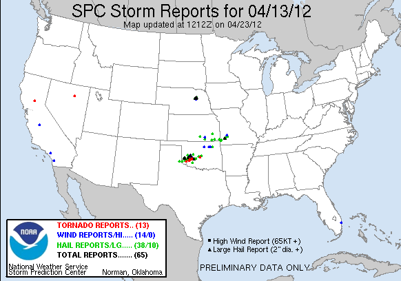
    Tornado Information for the April 13th, 2012 Tornadoes.


    0610 PM TORNADO 2 SE BLAIR 34.76N 99.31W
    04/13/2012 JACKSON OK STORM CHASER


    THE TORNADO PERSISTED FOR A COUPLE OF MINUTES BEFORE
    DISSIPATING.


    0616 PM TORNADO 3 SE BLAIR 34.75N 99.30W
    04/13/2012 JACKSON OK STORM CHASER


    0726 PM TORNADO 1 SSE COOPERTON 34.85N 98.87W
    04/13/2012 KIOWA OK NWS EMPLOYEE


    THIS BRIEF TORNADO OCCURRED WITH AT LEAST ONE OTHER
    TORNADO IN PROGRESS.


    0727 PM TORNADO 1 S COOPERTON 34.85N 98.88W
    04/13/2012 KIOWA OK NWS EMPLOYEE


    THIS TORNADO WAS LIKELY IN PROGRESS ALONG WITH AT LEAST
    ONE OTHER TORNADO.


    0728 PM TORNADO 3 SSW COOPERTON 34.82N 98.90W
    04/13/2012 KIOWA OK NWS EMPLOYEE


    A LARGE TORNADO MOVED EAST... WITH NO DAMAGE REPORTED.
    THE TORNADO WAS IN PROGRESS ALONG WITH AT LEAST ONE OTHER
    TORNADO.

    0754 PM TORNADO 6 NNE COOPERTON 34.94N 98.84W
    04/13/2012 KIOWA OK STORM CHASER


    THE TORNADO CONTINUED NORTHEAST AND LIFTED APPROXIMATELY
    2 MILES SSE OF CARNEGIE.


    0836 PM TORNADO 6 SSE CARNEGIE 35.02N 98.56W
    04/13/2012 CADDO OK NWS EMPLOYEE


    0842 PM TORNADO 8 SSE CARNEGIE 35.00N 98.55W
    04/13/2012 CADDO OK NWS EMPLOYEE


    0850 PM TORNADO 7 SSE CARNEGIE 35.01N 98.55W
    04/13/2012 CADDO OK NWS EMPLOYEE


    Preliminary Storm Information for the Norman, Oklahoma Tornado

    Beginning Time: ~3:59 pm CDT, April 13, 2012
    Ending Time: ~4:12 pm CDT, April 13, 2012
    Beginning Location: 3.7 Miles SW Norman (McClain County)
    Ending Location: 1.8 Miles NE Norman (Cleveland County)
    Fatalities: 0
    Injuries: 20
    EF-Scale Rating: EF-1 (Max Wind Speed 90-107 mph)
    The tornado developed just west of the Canadian River, north of the intersection of Santa Fe Avenue and SE 35th street at 3:59 pm CDT, and moved east-northeast toward the city of Norman.
    The tornado entered the southwest side of Norman at 4:01 pm CDT, and crossed Interstate Highway 35 (I-35) north of west Lindsey Street at 4:04 pm CDT. EF-1 damage was done to on either side of the interstate highway as the tornado began moving more toward the northeast.
    Additional EF-1 damage was reported north of Main Street, between Lahoma Avenue and Peters Avenue. The tornado finally lifted near the intersection NE 12th Avenue and Robinson Street at 4:12 pm CDT.
    Other damage that was located south of the tornado track was more likely due to strong winds associated with the rear flank downdraft. Most of this damage was confined to trees and power poles/lines.
    This tornado information should still be considered preliminary as we continue to look over information.

    More Details: http://www.srh.noaa.gov/oun/?n=events-20120413-norman

    Storm Photos Related the April 13, 2012
    Severe Weather Event in Oklahoma


    View: Looking west at the April 13, 2012 Norman, Oklahoma Tornado from the observatory deck of the National Weather Center. Photo provided courtesy of Alex Fierro.

    View: Looking southwest at the April 13, 2012 Norman, Oklahoma Tornado from near Max Westheimer Airport. Photo provided courtesy of Bob Fritchie.

    Tornado moving into Norman, OK. Photo Provided by Sterling Butler

    Brief Tornado near Shawnee, OK - Photo Provided by Don Lynch.


  7. Default Re: 2012 Oklahoma Tornado Tracking List

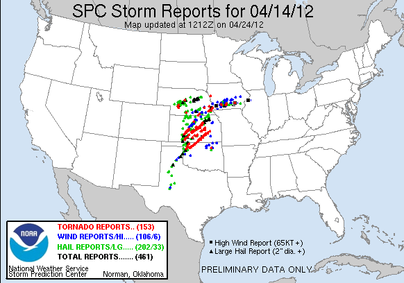
    April 14th Tornadoes


    The April 14-15, 2012 Woodward, Oklahoma Tornado

    The following summary was taken from a public information statement issued by the NWS Norman forecast office at 4:41 pm CDT on Monday, April 16, 2012.
    Preliminary Storm Information for the Woodward, Oklahoma Tornado

    Beginning Time: ~1150 pm CDT, April 14, 2012
    Ending Time: ~1227 am CDT, April 15, 2012
    Beginning Location: 2 NE Arnett (Ellis County)
    Ending Location: 4 N Woodward (Woodward County)
    Fatalities: 6
    Injuries: 29
    EF-Scale Rating: EF-3 (Max Wind Speed 136-165 mph)
    The tornado developed approximately 2 miles northeast of Arnett at 11:50 pm CDT on April 14, 2012 and moved northeast. Six structures were damaged as the tornado moved toward the Woodward county line. Only minor damage, downed trees and power poles/lines, was seen as the tornado moved over mainly rural portions of Woodward County.
    At approximately 12:12 am CDT on April 15, 2012, the tornado struck two mobile homes 5 miles southwest of Woodward. The damage here was determined to be EF-2 in intensity, and also resulted in 3 fatalities.
    The heaviest damage, rated EF-3, was reported as the tornado entered the southwest sides of Woodward around 12:18 am CDT. Several homes and businesses were heavily damaged as the tornado continued northeast.
    Several more mobile homes were destroyed by the tornado on the north side of Woodward, and resulted in 3 additional fatalities. The tornado finally exited the city of Woodward at approximately 12:23 am CDT, eventually dissipating approximately 4 miles north of Woodward at 12:27 am CDT.
    This tornado information should still be considered preliminary as we continue to look over information.
    Timeline for April 14-15, 2012 for Watches and Warnings Issued by the NWS Norman Forecast Office for the Woodward, OK Area

    10:45 am CDT PDS Tornado Watch, including Woodward County, valid until 600pm CDT
    5:25 pm CDT PDS Tornado Watch, including Woodward County, valid until 200am CDT
    10:35 pm CDT Severe Thunderstorm Warning Destructive winds to 70 mph and golf ball size hail
    11:13 pm CDT Severe Thunderstorm Warning Destructive winds to 70 mph and golf ball size hail; tornados can occur
    11:42 pm CDT Severe Weather Statement Destructive winds to 70 mph and golf ball size hail
    12:00 am CDT Tornado Warning, including the city of Woodward Trained storm spotters reported a tornado 7 miles southeast of Gage
    12:08 am CDT Severe Weather Statement Tornado with history of producing structural damage near Fargo
    12:16 am CDT Tornado Warning, including the city of Woodward Dangerous tornado with history of producing significant damage
    12:20 am CDT Severe Weather Statement At 1218 AM, a large dangerous tornado moving into Woodward
    12:33 am CDT Severe Weather Statement Large dangerous tornado with history of producing significant damage in Woodward

    Other Facts and Statistics

    • In the week leading up to the tornado (starting on April 9, 2012), Woodward County had been in 20 severe thunderstorm warnings, and 14 tornado warnings (including the warnings issued for the April 15, 2012 tornado). Two tornado warnings on April 14, 2012 (at 3:20 pm CDT and 4:59 pm CDT) included the city of Woodward.
    • If you had a weather radio programmed for just Woodward County, your radio would have alarmed 38 times (not including two Wednesday tests) between 2:30 pm CDT on Monday, April 9, 2012 and 1:15 am CDT on Sunday April 15, 2012.
    • On April 14th, your weather radio would have alarmed 22 times before the tornado warning was issued at 1200 AM CDT on April 15, 2012.
    • Woodward County was in a tornado watch continuously for 15 hours and 15 minutes on April 14-15, 2012.
    • Woodward County was under either a severe thunderstorm or tornado warning continuously for 4 hours and 14 minutes during the afternoon and evening on April 14, 2012.


    7 N WOODWARD WOODWARD OK 3653 9939 BRIEF TOUCHDOWN (OUN)
    2059 9 N WOODWARD WOODWARD OK 3656 9939 BRIEF TOUCHDOWN NEAR WOODWARD/HARPER COUNTY LINE (OUN)

    2130 4 NW FREEDOM WOODS OK 3681 9916 BRIEF TOUCHDOWN REPORTED BY KWTV-9. (OUN)
    2216 11 S TANGIER WOODWARD OK 3626 9953 BRIEF TOUCHDOWN (OUN)
    2350 5 S QUINLAN WOODWARD OK 3638 9905 RELAYED BY WOODWARD COUNTY EM (OUN)
    2350 4 S QUINLAN WOODWARD OK 3640 9905 RELAYED BY WOODWARD COUNTY EM (OUN)
    0008 11 S WAYNOKA MAJOR OK 3643 9888 (OUN)
    0008 8 S WAYNOKA MAJOR OK 3647 9888 (OUN)
    0012 7 SSE WAYNOKA WOODS OK 3649 9883 RELAYED BY WFO AMA (OUN)
    0012 6 SSE WAYNOKA WOODS OK 3650 9884 BRIEF TORNADO OCCURRED SIMULTANEOUSLY WITH TORNADO LOCATED JUST SOUTH. (OUN)
    0039 5 S HOPETON WOODS OK 3661 9867 THE TORNADO LASTED SEVERAL MINUTES (OUN)
    0041 DACOMA WOODS OK 3666 9856 THIS TORNADO CONTINUED NORTHEAST AND LIFTED APPROXIMATELY 3 MILES WEST-NORTHWEST OF CHEROKEE. TOWARD THE END OF ITS LIFE CYCLE ... A SECOND TORNADO DEVELOPED 2 MILES EAS (OUN)
    0055 4 W CHEROKEE ALFALFA OK 3675 9843 THIS TORNADO OCCURRED SIMULTANEOUSLY WITH A TORNADO THAT WAS LOCATED TWO MILES WEST. THE TORNADO CONTINUED NORTHEAST AND LIFTED NEAR BYRON AND AMORITA. A CEMETARY WAS D (OUN)
    0111 7 S DRIFTWOOD ALFALFA OK 3678 9836 (OUN)
    0124 4 E BYRON ALFALFA OK 3690 9822 THIS TORNADO CONTINUED NORTHEAST AND CROSSED INTO KANSAS APPROXIMATELY 2 WEST OF MANCHESTER IN GRANT COUNTY AT 2039 CDT.(OUN)
    0518 WOODWARD WOODWARD OK 3643 9939 *** 6 FATAL, 29 INJ ***THE TORNADO BEGIN AROUND 2350 CDT 3 MILES NORTHEAST OF ARNETT AND CONTINUED NORTHEAST INTO WOODWARD COUNTY. THE TORNADO MOVED INTO THE SOUTHWEST (OUN)
    1049 4 SW SKIATOOK OSAGE OK 3633 9605 NWS STORM SURVEY FOUND TORNADO DAMAGE THAT BEGAN 4.8 MILES SOUTHWEST OF SKIATOOK AND ENDED JUST NORTHEAST OF THE SKIATOOK MUNICIPAL AIRPORT. RATING WAS EF-1 BASED ON TR (TSA)
    Storm Photos Related the April 14-15, 2012
    Great Plains Severe Weather Outbreak


    Brief Tornado near Freedom, OK
    Photo Provided by Tim Marshall
    Brief Tornado near Freedom, OK
    Photo Provided by Tim Marshall
    Tornado near Wayonka, OK
    Photo Provided by Tim Marshall
    Tornado near Wayonka, OK
    Photo Provided by Tim Marshall
    Tornado near Cherokee, OK
    Photo Provided by Tim Marshall
    Dual Tornadoes near Cherokee, OK
    Photo Provided by Shawn Prindle
    Tornado east of Byron, OK
    Photo Provided by Charles Kuster
    Tornado at Dusk near Manchester, OK
    Photo Provided by Charles Kuster
    Tornado near Manchester, OK
    Photo Provided by Charles Kuster
    Tornado near Manchester, OK
    Photo Provided by Charles Kuster
    Tornado near Manchester, OK
    Photo Provided by Charles Kuster

Thread Information

Users Browsing this Thread

There are currently 1 users browsing this thread. (0 members and 1 guests)

Similar Threads

  1. Oklahoma Commercial Air Service Discussion 2012
    By venture in forum Transportation
    Replies: 437
    Last Post: 12-29-2012, 03:18 AM
  2. Oklahoma Earthquakes 2012
    By venture in forum Current Events & Open Topic
    Replies: 12
    Last Post: 10-18-2012, 10:14 AM
  3. US Fleet Tracking Basketball Invitational
    By inquisitive_mind in forum Sports
    Replies: 30
    Last Post: 10-25-2011, 06:33 PM
  4. Oklahoma tops list of highest divorce rates
    By Jersey Boss in forum Current Events & Open Topic
    Replies: 19
    Last Post: 09-16-2011, 11:52 AM

Bookmarks

Posting Permissions

  • You may not post new threads
  • You may not post replies
  • You may not post attachments
  • You may not edit your posts
  •  
Single Sign On provided by vBSSO