


Tornado watch now out until noon. It covers from the southwest corner of Oklahoma, northeast almost to Bartlesville. It includes Oklahoma City. Strong to severe thunderstorms have formed in the watch area as of 5:40 am. http://stillwaterweather.com

Tornado watch now out until noon. It covers from the southwest corner of Oklahoma, northeast almost to Bartlesville. It includes Oklahoma City. Strong to severe thunderstorms have formed in the watch area as of 5:40 am. http://stillwaterweather.com
 Banned

I'm hoping we get some rain.
David
Bulletin - immediate broadcast requested
severe thunderstorm warning
national weather service norman ok
919 am cst tue jan 29 2013
the national weather service in norman has issued a
* severe thunderstorm warning for...
Southeastern canadian county in central oklahoma...
Northwestern cleveland county in central oklahoma...
Northeastern grady county in central oklahoma...
Western lincoln county in central oklahoma...
Southeastern logan county in central oklahoma...
Northwestern mcclain county in central oklahoma...
Oklahoma county in central oklahoma...
* until 1000 am cst
* at 917 am cst...national weather service meteorologists detected a
severe thunderstorm capable of producing quarter size hail and
damaging winds in excess of 65 mph. This storm was located 5 miles
northwest of newcastle...moving northeast at 65 mph.
* locations impacted include...
Moore...oklahoma city...and luther.
David
Confirmed 1" hail in Warr Acres.
David
Here are the two Tornado Watches in effect right now:
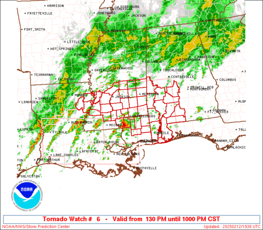
David
This is a dual pol image that I posted during the winter weather stuff we had. For severe weather you can look at this image and the areas shaded in red is where the radar is detecting hail falling.
David
Who would have thought...
FLOOD ADVISORY
NATIONAL WEATHER SERVICE NORMAN OK
934 AM CST TUE JAN 29 2013
OKC109-291730-
/O.NEW.KOUN.FA.Y.0001.130129T1534Z-130129T1730Z/
/00000.N.ER.000000T0000Z.000000T0000Z.000000T0000Z. OO/
OKLAHOMA OK-
934 AM CST TUE JAN 29 2013
THE NATIONAL WEATHER SERVICE IN NORMAN HAS ISSUED A
* URBAN AND SMALL STREAM FLOOD ADVISORY FOR...
OKLAHOMA COUNTY IN CENTRAL OKLAHOMA...
* UNTIL 1130 AM CST
* AT 927 AM CST...THE PUBLIC REPORTED HEAVY RAIN CAUSING URBAN AND
SMALL STREAM FLOODING IN EDMOND AND NORTH OKLAHOMA CITY.
* SOME LOCATIONS THAT WILL EXPERIENCE MINOR FLOODING INCLUDE
OKLAHOMA CITY...EDMOND...MIDWEST CITY...DEL CITY...BETHANY...THE
VILLAGE...WARR ACRES...CHOCTAW...HARRAH...NICHOLS HILLS...
SPENCER...JONES...NICOMA PARK...LUTHER...ARCADIA AND TINKER AIR
FORCE BASE.
ADDITIONAL RAINFALL OF AN INCH OR MORE IS EXPECTED OVER THE AREA.
PRECAUTIONARY/PREPAREDNESS ACTIONS...
EXCESSIVE RUNOFF FROM HEAVY RAINFALL WILL CAUSE ELEVATED LEVELS ON
SMALL CREEKS AND STREAMS...AND PONDING OF WATER IN URBAN AREAS...
HIGHWAYS...STREETS AND UNDERPASSES AS WELL AS OTHER POOR DRAINAGE
AREAS AND LOW LYING SPOTS.
David
Radar estimates of rainfall - any hail will throw these off, so these are going to appear too high in some places.

David
Tornado watch paired back some...
WATCH COUNTY NOTIFICATION FOR WATCH 5
NATIONAL WEATHER SERVICE NORMAN OK
1028 AM CST TUE JAN 29 2013
OKC027-049-081-087-125-137-291800-
/O.CON.KOUN.TO.A.0005.000000T0000Z-130129T1800Z/
TORNADO WATCH 5 REMAINS VALID UNTIL NOON CST TODAY FOR THE
FOLLOWING AREAS
IN OKLAHOMA THIS WATCH INCLUDES 6 COUNTIES
IN CENTRAL OKLAHOMA
CLEVELAND LINCOLN MCCLAIN
POTTAWATOMIE
IN SOUTHERN OKLAHOMA
GARVIN STEPHENS
THIS INCLUDES THE CITIES OF...CHANDLER...DUNCAN...MOORE...
NORMAN...PAULS VALLEY...PURCELL AND SHAWNEE.
David
MESOSCALE DISCUSSION 0068
NWS STORM PREDICTION CENTER NORMAN OK
0946 AM CST TUE JAN 29 2013
AREAS AFFECTED...NERN TX...SERN OK...WRN AR
CONCERNING...SEVERE POTENTIAL...TORNADO WATCH LIKELY
VALID 291546Z - 291745Z
PROBABILITY OF WATCH ISSUANCE...95 PERCENT
SUMMARY...STORMS SHOULD CONTINUE TO INCREASE IN COVERAGE ACROSS NERN
TX...SERN OK...AND WRN AR...WITH A THREAT OF TORNADOES AND DAMAGING
WINDS.
DISCUSSION...A MOIST AIR MASS IS IN PLACE ACROSS THE REGION WITH
DEWPOINTS RISING INTO THE MID 60S F. ALTHOUGH HEATING WILL REMAIN
LIMITED...FORCING FOR ASCENT WILL BE ON THE INCREASE THROUGH THE
DAY. ASIDE FROM THE COLD FRONT WHICH CURRENTLY EXTENDS FROM OKC TO
SPS...CONFLUENCE FLOW WITHIN THE MOIST AXIS AND BENEATH A 65 KT LOW
LEVEL JET SHOULD RESULT IN ADDITIONAL CONVECTION ACROSS THE WARM
SECTOR.
WIND PROFILES ARE VERY STRONG WITH VWP AND PROFILER DATA INDICATING
0-1 SRH IN EXCESS OF 400 M2/S2. FURTHER....THE 12Z FWD SOUNDING
SHOWED STEEP MIDLEVEL LAPSE RATES IN PLACE. WHILE INITIAL ATTEMPTS
AT NEW STORMS MAY BE SLOW DUE TO MARGINAL CAPPING...SUPERCELLS ARE
EXPECTED TO MATERIALIZE ONCE DEEP CONVECTION IS REALIZED AND
TORNADOES AS WELL AS DAMAGING WINDS WITH BOWS ARE LIKELY.
David
New severe storm moving into Garvin County from Stephens. Should clip the far east sides of the Metro area (Pott county) based on its current track.
David
Wwus30 kwns 291657
saw7
spc aww 291657
ww 7 tornado ar ok tx 291700z - 300100z
axis..80 statute miles east and west of line..
35nw rkr/poteau ok/ - 80s prx/paris tx/
..aviation coords.. 70nm e/w /39w fsm - 36w ggg/ hail surface and aloft..2 inches. Wind gusts..65 knots.
Max tops to 450. Mean storm motion vector 23045.
Tornadoes
Wind
Probability of 2 or more tornadoes
Probability of 1 or more strong (F2-F5) tornadoes
Hail
Probability of 10 or more severe wind events
Probability of 1 or more wind events > 65 knots
Combined Severe Hail/Wind
Probability of 10 or more severe hail events
Probability of 1 or more hailstones > 2 inches
Probability of 6 or more combined severe hail/wind events
URGENT - IMMEDIATE BROADCAST REQUESTED
TORNADO WATCH NUMBER 7
NWS STORM PREDICTION CENTER NORMAN OK
1100 AM CST TUE JAN 29 2013
THE NWS STORM PREDICTION CENTER HAS ISSUED A
TORNADO WATCH FOR PORTIONS OF
WESTERN ARKANSAS
SOUTHEAST OKLAHOMA
NORTHEAST TEXAS
EFFECTIVE THIS TUESDAY MORNING AND EVENING FROM 1100 AM UNTIL 700
PM CST.
SEVERAL TORNADOES
ISOLATED INTENSE TORNADOES POSSIBLE
SCATTERED DAMAGING WINDS
ISOLATED WIND GUSTS TO 65 MPH POSSIBLE
WIDELY SCATTERED LARGE HAIL TO 2.0 INCHES IN DIAMETER
THE TORNADO WATCH AREA IS APPROXIMATELY ALONG AND 80 STATUTE
MILES EAST AND WEST OF A LINE FROM 35 MILES NORTHWEST OF POTEAU
OKLAHOMA TO 80 MILES SOUTH OF PARIS TEXAS. FOR A COMPLETE
DEPICTION OF THE WATCH SEE THE ASSOCIATED WATCH OUTLINE UPDATE
(WOUS64 KWNS WOU7).
REMEMBER...A TORNADO WATCH MEANS CONDITIONS ARE FAVORABLE FOR
TORNADOES AND SEVERE THUNDERSTORMS IN AND CLOSE TO THE WATCH
AREA. PERSONS IN THESE AREAS SHOULD BE ON THE LOOKOUT FOR
THREATENING WEATHER CONDITIONS AND LISTEN FOR LATER STATEMENTS
AND POSSIBLE WARNINGS.
OTHER WATCH INFORMATION...CONTINUE...WW 5...WW 6...
DISCUSSION...A BAND OF PRE-FRONTAL ASCENT OVERSPREADING NE TX/SE OK
WILL SUPPORT NEW THUNDERSTORM DEVELOPMENT THROUGH THIS AFTERNOON
WITHIN THE UNSTABLE WARM SECTOR. THOUGH CLOUDS ARE LIMITING SURFACE
HEATING...DEWPOINTS IN THE MID 60S AND REMNANT STEEP MIDLEVEL LAPSE
RATES WILL DRIVE MLCAPE TO THE 750-1500 J/KG RANGE BY EARLY-MID
AFTERNOON. VERTICAL SHEAR IS FAVORABLE FOR SUPERCELLS AND BOWING
SEGMENTS ACROSS THE WATCH AREA...AND THIS WILL SUPPORT A RISK FOR
TORNADOES...DAMAGING WINDS...AND AT LEAST ISOLATED LARGE HAIL
THROUGH THIS EVENING.
David
Intensities are definitely picking up as the activity continues to move away from I-35. OKC definitely got away with just a good down pour and a little hail.
Participating Member
Ahhh! What is this wet stuff falling from the sky?! I don't understand!
Participating Member
Ah yes, soil moisturizer. Best if applied daily, to avoid dry spots and unsightly crevices.Originally Posted by ShiroiHikari


David
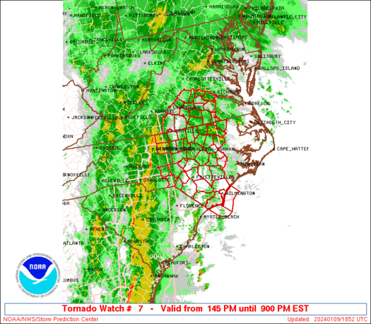
Outside of our main focus area here, but I believe this is the first tornado warning of the year for the state.
BULLETIN - EAS ACTIVATION REQUESTED
TORNADO WARNING
NATIONAL WEATHER SERVICE TULSA OK
251 PM CST TUE JAN 29 2013
THE NATIONAL WEATHER SERVICE IN TULSA HAS ISSUED A
* TORNADO WARNING FOR...
NORTHEASTERN SEQUOYAH COUNTY IN EAST CENTRAL OKLAHOMA
SOUTHEASTERN ADAIR COUNTY IN NORTHEAST OKLAHOMA
NORTHWESTERN CRAWFORD COUNTY IN NORTHWEST ARKANSAS
SOUTHWESTERN WASHINGTON COUNTY IN NORTHWEST ARKANSAS
* UNTIL 330 PM CST
* AT 246 PM CST...A SEVERE THUNDERSTORM WITH STRONG LOW LEVEL
ROTATION WAS LOCATED 4 MILES WEST OF SHORT...MOVING NORTHEAST AT 50
MPH. A TORNADO IS OCCURRING OR IMMINENT.
* SOME LOCATIONS IN OR NEAR THE PATH OF THIS STORM INCLUDE...NATURAL
DAM...LEE CREEK...STRICKLER...DEVILS DEN STATE PARK...BLACKBURN AND
WINSLOW.
PRECAUTIONARY/PREPAREDNESS ACTIONS...
IF YOU ARE NEAR THE PATH OF THIS STORM...TAKE COVER NOW! IF NO
UNDERGROUND SHELTER IS AVAILABLE MOVE TO AN INTERIOR ROOM ON THE
LOWEST FLOOR. MOBILE HOMES AND VEHICLES SHOULD BE ABANDONED FOR MORE
SUBSTANTIAL SHELTER. AVOID WINDOWS!
David
Appears as though there very well could be a significant tornado in NE Crawford County, AR...just across the border from OK.

David
Looking some moderate rain kicking up now over Lake Dirtybird. More showers out to the west will be working in as well later. Oh yeah...this will all eventually change over to snow tonight.Here is the snowfall forecast from HRRR...

Participating Member
The drought is over my friends
Hold up...Just checked and apparently I'm wrong
Participating Member
I'm glad this January thread is nearly complete. Keeping my fingers crossed for more interesting days in February.
Does anyone else want to shake the news, and especially weather, people, when they mention how very rare severe storms and tornadoes are in the winter? I mean, they happen every year. True, it's outside "season" but that doesn't make it rare. We know there are three tornado seasons, don't we?
Participating Member

It's odd, not rare. I agree.
David
Again, don't take this to the bank...

Participating Member
A BLIZZARD!!!!!!!!!!!!!!!!! HELL YEAAAHHHH!!!! lol jk
Participating Member
This is the misconception with all "major" weather events.
All of these 'rare and extreme' occurances happen throughout the year...every year.
Mainstream media and general public are simply dramatic and unaware of how averages work.
Participating Member
Time lapse video of the system that came through on Tuesday:
By Mat Hoffman, of skateboard fame.
There are currently 1 users browsing this thread. (0 members and 1 guests)
 Posting Permissions

 Reply With Quote
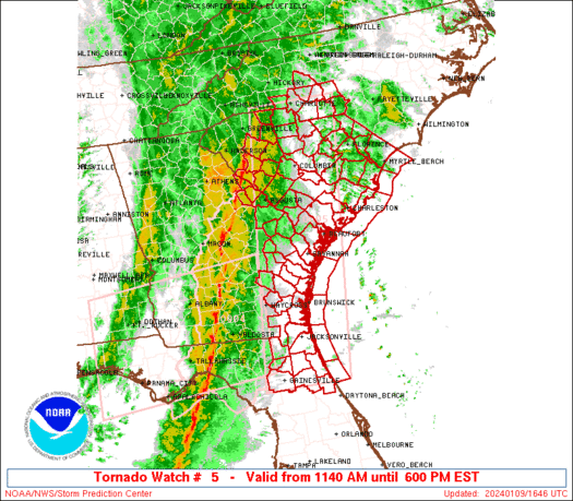


Bookmarks