Widgets Magazine
Page 4 of 7 FirstFirst 1234567 LastLast
Results 76 to 100 of 173

Thread: General Weather Discussion - June 2015

  1. #76

    Default Re: General Weather Discussion - June 2015

    Interestingly, KFOR's projected precip map peaks out at 5.3" with heavier amounts than KOCO's to the west of I-35.

    Stillwater has been bypassed enough by the most recent rains, so that my new soil moisture sensor shows a reading of 3. Zero represents total saturation. A reading of 200 would mean very dry. I think Stillwater can handle KOCO's projected amount of 1.3" while less certain of KFOR's amount of nearly 3", especially for reality.

    I do feel sorry for those folks who can't seem to get a break from extra heavy rains this season.

  2. #77

    Default Re: General Weather Discussion - June 2015

    Quote Originally Posted by OKCisOK4me View Post
    Last night when they first issued the flash Flood watch, Oklahoma County was the most north and west county in the watch. Now I see they've added Logan, Kingfisher, and Canadian.
    Payne County, too, and all of northeast Oklahoma to the northeast of there.


  3. Default Re: General Weather Discussion - June 2015

    Do they make dome-like covers you can put over your property to keep it dry? I sure could use something like that right about now.

    Someone smart, go invent that right meow!
    Still corrupting young minds

  4. #79

    Default Re: General Weather Discussion - June 2015

    Quote Originally Posted by Bunty View Post
    Payne County, too, and all of northeast Oklahoma to the northeast of there.

    I was just speaking of westward expansion but GO POKES!

  5. #80

    Default Re: General Weather Discussion - June 2015

    Dallas/Ft Worth is going to take a direct hit.

    Right now it looks like OKC metro may dodge the heaviest stuff by a couple handfuls of miles.

  6. #81
    Uncle Slayton Guest

    Default Re: General Weather Discussion - June 2015

    Quote Originally Posted by Anonymous. View Post
    Dallas/Ft Worth is going to take a direct hit.

    Right now it looks like OKC metro may dodge the heaviest stuff by a couple handfuls of miles.
    To quote Dr. Peter Venckmann, I'm fuzzy on the whole good / bad thing. Can you flesh out "heaviest" and apply it to near-west Norman?

  7. Default Re: General Weather Discussion - June 2015

    Quote Originally Posted by Bunty View Post
    Interestingly, KFOR's projected precip map peaks out at 5.3" with heavier amounts than KOCO's to the west of I-35.

    Stillwater has been bypassed enough by the most recent rains, so that my new soil moisture sensor shows a reading of 3. Zero represents total saturation. A reading of 200 would mean very dry. I think Stillwater can handle KOCO's projected amount of 1.3" while less certain of KFOR's amount of nearly 3", especially for reality.

    I do feel sorry for those folks who can't seem to get a break from extra heavy rains this season.
    Any focus on exact amounts right now is purely foolish. I'll ignore the rest of the Stillwater pity party that seems to be ongoing.

  8. #83

    Default Re: General Weather Discussion - June 2015

    Quote Originally Posted by venture View Post
    Any focus on exact amounts right now is purely foolish. I'll ignore the rest of the Stillwater pity party that seems to be ongoing.
    Then Venture, you or others should report members to the monitor, who are making inappropriate postings to this portion of the forum. Quite frankly, though, there is a leak in my roof, and I would prefer less rain, not more, until the roofer gets around to fixing it.

  9. #84
    Join Date
    Feb 2015
    Posts
    2,064
    Blog Entries
    1

    Default Re: General Weather Discussion - June 2015

    Click image for larger version. 

Name:	image.jpg 
Views:	116 
Size:	1.87 MB 
ID:	10953

    Very far SW Okla today - cannot explain how green it is out there! Really beautiful. Had over 10 inches of rain since late last week. Incredible.

  10. #85

    Default Re: General Weather Discussion - June 2015

    Quote Originally Posted by okatty View Post
    Click image for larger version. 

Name:	image.jpg 
Views:	116 
Size:	1.87 MB 
ID:	10953

    Very far SW Okla today - cannot explain how green it is out there! Really beautiful. Had over 10 inches of rain since late last week. Incredible.
    I've been out there before as far as Altus. I loved the quite noticeable change in scenery from mesquite trees along the highway to part of the the horizon lined with rocky looking hills.

  11. #86
    Join Date
    Feb 2015
    Posts
    2,064
    Blog Entries
    1

    Default Re: General Weather Discussion - June 2015

    Quote Originally Posted by Bunty View Post
    I've been out there before as far as Altus. I loved the quite noticeable change in scenery from mesquite trees along the highway to part of the the horizon lined with rocky looking hills.
    That is Hwy 30 South of Erick heading toward Hollis. Really rugged area. There is a cool conservation area (Sandy Saunders) that you can hike or drive thru.

  12. Default Re: General Weather Discussion - June 2015

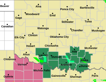
    00Z NAM Update on Bill...

    Main northern bands should enter the state by day break tomorrow. Center of rotation should be just over/west of Fort Worth by 5PM.


    Significant rain band projected to setup over Central OK along/near I-44 by mid to late evening.


    The system should then start a march east by Thursday afternoon ending most of the heavy rain chances in Central OK...


    Rainfall forecasts per NAM...


  13. #88

    Default Re: General Weather Discussion - June 2015

    Should get some impressive rainfall amounts heading into this evening. Main part of the storm will be arriving at peak daytime heating, going to be a rainforest out there.

  14. #89

    Default Re: General Weather Discussion - June 2015

    Latest NAM hinting at a potential stall-out of the low somewhere over EC OK.

  15. #90

    Default Re: General Weather Discussion - June 2015

    Quote Originally Posted by Anonymous. View Post
    Latest NAM hinting at a potential stall-out of the low somewhere over EC OK.
    You've gotta be kidding me.....

  16. #91

    Default Re: General Weather Discussion - June 2015

    Here we go. Outer band has developed right along I-44 over OKC.

    Should see steady increase in rain from here on out.

  17. #92

    Default Re: General Weather Discussion - June 2015

    So does this put South OKC and Moore in the heavy rainfall with Bill? Will the stall out you mentioned over E Central Oklahoma affect these same areas with prolonged heavy rainfall? I have a flooding issue at my home in Moore so trying to see what if anything I need to do to prepare for my area. Thanks!!

  18. #93

    Default Re: General Weather Discussion - June 2015

    Quote Originally Posted by Anonymous. View Post
    Latest NAM hinting at a potential stall-out of the low somewhere over EC OK.
    What does this mean, exactly?

  19. #94

    Default Re: General Weather Discussion - June 2015

    Quote Originally Posted by Bobby821 View Post
    So does this put South OKC and Moore in the heavy rainfall with Bill? Will the stall out you mentioned over E Central Oklahoma affect these same areas with prolonged heavy rainfall? I have a flooding issue at my home in Moore so trying to see what if anything I need to do to prepare for my area. Thanks!!
    If you are prone to flooding, then you need to prepare now (if any sandbags are left).

  20. #95

    Default Re: General Weather Discussion - June 2015

    Quote Originally Posted by emounger View Post
    What does this mean, exactly?
    That potential is there for the system to hang around Eastern/Northeastern OK longer than initially expected.

  21. #96

    Default Re: General Weather Discussion - June 2015

    Quote Originally Posted by Anonymous. View Post
    If you are prone to flooding, then you need to prepare now (if any sandbags are left).
    How many cubits in a foot?

  22. #97

    Default Re: General Weather Discussion - June 2015

    In regards to Central OK, still looks like E of I-35 and south of I-44 is going to be the main flood corridor.

    GFS loading in now, should have good idea on track.

  23. #98

    Default Re: General Weather Discussion - June 2015

    Looks like it's heading straight for OKC. Norman, Moore, OKC ... maybe as far as Warr Acres and El Reno.

  24. #99

    Default Re: General Weather Discussion - June 2015

    GFS slides track a littler further east.

    Models are basically in agreement that a sharp NE turn is about to occur. This will spare most of OKC and possibly Tulsa metros.

  25. #100

    Default Re: General Weather Discussion - June 2015

    Quote Originally Posted by Anonymous. View Post
    GFS slides track a littler further east.

    Models are basically in agreement that a sharp NE turn is about to occur. This will spare most of OKC and possibly Tulsa metros.
    boo

Thread Information

Users Browsing this Thread

There are currently 2 users browsing this thread. (0 members and 2 guests)

Similar Threads

  1. General Weather Discussion - May 2015
    By venture in forum Weather & Geosciences
    Replies: 623
    Last Post: 06-03-2015, 10:22 PM
  2. General Weather Discussion - April 2015
    By venture in forum Weather & Geosciences
    Replies: 364
    Last Post: 04-29-2015, 11:39 PM
  3. General Weather Discussion - March 2015
    By venture in forum Weather & Geosciences
    Replies: 521
    Last Post: 04-06-2015, 11:04 PM
  4. General Weather Discussion - January/February 2015
    By venture in forum Weather & Geosciences
    Replies: 525
    Last Post: 03-01-2015, 03:38 PM
  5. General Weather Discussion - June 2014
    By venture in forum Weather & Geosciences
    Replies: 363
    Last Post: 07-06-2014, 02:21 PM

Bookmarks

Posting Permissions

  • You may not post new threads
  • You may not post replies
  • You may not post attachments
  • You may not edit your posts
  •  
Single Sign On provided by vBSSO