

GFS maintaining the trend of us being in the 70s middle of next week.Originally Posted by ljbab728


 David
David

GFS maintaining the trend of us being in the 70s middle of next week.
Participating Member

Venture, is there any reason why this type of weather is happening? It seems our weather has been really weird here lately.
Participating Member
KFOR is predicting a high of 73 next Wednesday. That will feel almost chilly for this time of year.
Guest
Because it's Oklahoma, plupan. Our weather is always weird. And remember, we got a fair amount of rain last summer also.
Participating Member
We just happen to be in that sweet spot of the country that gets so many systems interacting with it.
David
Pattern is going to be a little wonky this year. I would imagine some of it has to do with El Nino effecting things slightly. Getting these fronts surviving this far south, in July, usually doesn't happen.
Participating Member
Yeah, that's what I was thinking. El Nino usually means a cooler, wetter summer for the Southern Plains. Much better than La Nina, which was responsible for the summers of 2011 and 2012.
David
Some rain and storms starting to develop in NW OK and will be moving SE over night. We'll see how widespread things get.
David
Some images from the GFS run this evening...
The Death Ridge killer Sunday Morning over Central Canada.
By Tuesday AM the Ridge is pretty much pushed well into the SW US...
Through the end of the month will be kept mostly over the Four Corners region.
Next Week's precip chances start Tuesday early as the front pushed through the entire state. Wednesday looks mostly dry, but some isolated storms around. Stronger wave moves through on Thursday with more storms and continues into Friday. So it does look the typical July won't happen this year. A couple really hot days coming up and cooler weather.
 Participating Member
Looks like we could be keeping things green through July if next week comes through as forecast.
Hopefully August and September don't roast us out for a grand finalee. It would be nice to have some moisture leftover heading into winter this year.
Participating Member
Yeah, I'll take the bills over the batch (swap the vowels) anytime when it comes to Oklahoma summers!
Today is Tulsa's turn at having a downpour as heavy rain has been going through there. From the web cams at http://stillwaterweather.com, you can see the sharp contrast between downtown OKC and Tulsa, if weather conditions are still prevailing.
Participating Member
Tulsa is sitting at 68 degrees with +2 inches of rainfall. I bet that feels pretty good.
Poor man?s polar vortex to make shocking summer return in eastern U.S. next week
After surviving driving through absolutely the worst rain ever just south of Kansas City, a little over a week ago, and feeling moved to get out of harm's way by trying to follow the white line defining the Interstate roadway upon which we were traveling into a sheltered area provided by a fuel stop in Belton, MO, then accessing the Internet link to the local weather radar, and refueling at the same time while waiting for the storm to pass it was obvious that we were in the exact--purple on the radar--center of the storm.
We ran into some other weather flurries, on the highway, on up into Iowa that continued all the way to Albert Lea, MN.
Bad as some of them were, they didn't hold a candle to that Missouri rainstorm.
Up Nord, the temperatures started in the high 50's early in the morning and rose to the high 70's and low 80's during the day.
The locals were complaining how hot it was. I simply smiled. =)
I guess the question is: Will the lawn be dry enough to mow tomorrow in order to fit it into my busy, post-vacation. schedule?
(and the other part of the question might be: is all of the "wastewater" being pumped into the ground, perhaps causing these pesky earthquakes, also sending a signal somewhere that causes all the rain to appear where they don't need it? =)
Sure hope the "Poor Man'?s" Polar Vortex Don't Fail t' Arrive, Posthaste . . . =)
(so as to not take any of the above verbiage in the wrong way: this thread and Accuweather are my primary sources regarding things over which we have no control except in terms of how we respond to conditions.)
Participating Member
So...this rain event that KFOR Channel 4 is touting for next week on Wednesday, Thursday, and Friday....will this be a statewide rain event or is it mainly going to hit the center part of the state? I'm just wondering if the rain will be coming down here to Duncan.
Our town's "World's Largest Garage Sale" is scheduled for next Friday and Saturday (July 18-19), and I'm having a sale at my house. Since three families will be selling their stuff in my garage and on my driveway, I'm wondering about the weather.
David
Through Thursday...

Participating Member
Thank you, Venture!
Participating Member
generic showers and storms firing along the front draped across OK right now. Western OK into C OK. This line may continue to fire off garden variety storms, main threat will be heavy rain.
What's the latest model data show for the rain event mid-week, guys?
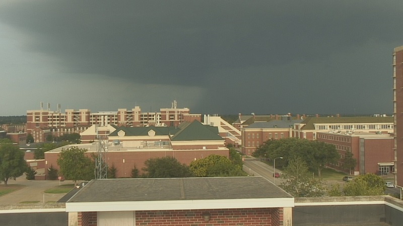
Photo, as of 7pm, of severe thunderstorm bypassing OSU-Stillwater. No storm soon for OKC, but that could change as conditions develop.
David
Quick radar grab...but there are a few boundaries out there. I'm sure I missed a few. LOL

David
Today is same as yesterday...scattered storms with isolated severe winds and hail.
Forecast rain fall totals for the next few days...NAM likes NE OK, GFS like South Central OK...

Participating Member
GO GFS!!!! My pond in Carter County is still about 10 feet low!!!!!
David
Storm going up in Norman right now will cause some isolated flash flooding as it ramps up due to moving very slowly or not at all.

There are currently 1 users browsing this thread. (0 members and 1 guests)
 Posting Permissions


 Reply With Quote


Bookmarks