Widgets Magazine
Page 5 of 7 FirstFirst 1234567 LastLast
Results 101 to 125 of 155

Thread: Oklahoma Weather Discussion - January 2013

  1. #101

    Default Re: Oklahoma Weather Discussion - January 2013

    Quote Originally Posted by venture79 View Post
    I personal don't believe we have enough historical data to concretely say we have had an impact. However, we can look at the growth of the human population and really any CO2 producer and the decline in CO2 consuming organisms and eventually there is going to be a trade off. CO2 is a green house gas and the more of it around, the warmer things will get. So the less plant life around to eat up the CO2 the worse off things will get.

    I have my faith in nature though that it will do what it always does...balance things back out. Might not be good for us, but we aren't the only living organism on this grain of sand.
    Well, that's my point. That, maybe, it's a 70 or 80 year cycle that dust storms will come and go in this region of the country while the jet stream goes through its migratory pattern, if you will. It's the meteorological portion of the ecological system.

    So, I'd assume that before the 1930s Dust Bowl, there was another drought of the magnitudes 70 or 80 years beforehand that affected our very region. How many people were in this region to record those? Are there records of that happening here during that time frame? I mean, there were settlers making their way out west at that time, but this area was Indian Territory then. The AT&SF may have been surveyed in the 1870s if I recall correctly so other than that, are there records of weather events?

  2. #102

    Default Re: Oklahoma Weather Discussion - January 2013

    Quote Originally Posted by OKCisOK4me View Post
    Wouldn't all of this be due to the jet stream?

    Why has the jet stream changed?

    Is it due to human involvement?

    I mean, I'm not a big believer of the whole Inconvenient Truth, Al Gore film but why has it been dry so frequently for the last few years?? Is it a natural cycle and we're just putting a greater dent in it by more humans being present or what?
    Check out Haarp and decide for yourself what you think about it.

  3. #103

    Default Re: Oklahoma Weather Discussion - January 2013

    Quote Originally Posted by Plutonic Panda View Post
    Check out Haarp and decide for yourself what you think about it.
    Hopefully you're not serious?

  4. #104

    Default Re: Oklahoma Weather Discussion - January 2013

    Quote Originally Posted by LocoAko View Post
    Hopefully you're not serious?
    Young minds are impressionable...

  5. #105

    Default Re: Oklahoma Weather Discussion - January 2013

    Quote Originally Posted by OKCisOK4me View Post
    Well, that's my point. That, maybe, it's a 70 or 80 year cycle that dust storms will come and go in this region of the country while the jet stream goes through its migratory pattern, if you will. It's the meteorological portion of the ecological system.
    Actually that's an excellent suggestion. Tree-ring research ought to be able to shed light on it, too; such a cycle of extreme drouth conditions ought to show up quite clearly in the tree rings if anyone looked for it.

    Back in the mid-40s, when I was still in junior high school, I was an avid reader of "Popular Science" and "Mechanix Illustrated" magazines, and one of my favorite writers was a fellow named Willy Ley. He wrote about all sorts of things, and even touched on the possibility of splitting the atom (a year or two before Trinity and Hiroshima). One of his articles, about the importance of cycles in human events and in nature, has stuck with me over the years. Starting with the 11-year sunspot cycle, he explored other, longer-term cycles as shown by history. One of his examples was a 400-year cycle of the geographical positioning of power, and he wrote that this cycle predicted a swing of the center of power from the region bordering the Atlantic, over to Asia, beginning in the late 40s, peaking in the 22nd century, and returning to the Atlantic region in the 24th. It's a bit too soon to know for sure, but the powers in Asia are certainly more prominent now than they were 70 years ago, and those around the Atlantic seem to be shrinking...

    Meteorologists are aware of seasonal cycles of the jet stream and speak of it all the time. It's not unreasonable to suggest that longer cycles may also exist...
    Last edited by Jim Kyle; 01-26-2013 at 10:45 AM. Reason: spelling error

  6. #106

    Default Re: Oklahoma Weather Discussion - January 2013

    Quote Originally Posted by LocoAko View Post
    Hopefully you're not serious?

  7. #107

    Default Re: Oklahoma Weather Discussion - January 2013

    Quote Originally Posted by Plutonic Panda View Post
    Heh. Phew.

  8. #108

    Default Re: Oklahoma Weather Discussion - January 2013

    Quote Originally Posted by Uncle Slayton View Post
    Brilliant. Thank you. Somewhere out there, HWTJ's hands started twitching uncontrollably and he's having recurring urges to stop what he's doing and graph something.
    Ironically enough, I was reading a story today about the area around the old Chernobyl reactor that was cordoned off and abandoned as dangerously unlivable due to radiation...but in the intervening quarter-century has now become a natural hotspot for several varieties of animals, none of which are showing up with three eyeballs or two heads. Once again, God shows us that He really is in control and, somehow, manages to keep thing going in spite of man's profound, self-absorbed, "wisdom."

    Sorry, don't mean to diverge, just echoing Venture's point that somehow these things balance out. God is a God of order, not chaos, and that's right back where things are going to go.

  9. #109

    Default Re: Oklahoma Weather Discussion - January 2013

    Quote Originally Posted by SoonerDave View Post
    Ironically enough, I was reading a story today about the area around the old Chernobyl reactor that was cordoned off and abandoned as dangerously unlivable due to radiation...but in the intervening quarter-century has now become a natural hotspot for several varieties of animals, none of which are showing up with three eyeballs or two heads. Once again, God shows us that He really is in control and, somehow, manages to keep thing going in spite of man's profound, self-absorbed, "wisdom."

    Sorry, don't mean to diverge, just echoing Venture's point that somehow these things balance out. God is a God of order, not chaos, and that's right back where things are going to go.
    Yeah, lower forms of life with shorter lifespans often thrieve when humans are not around. Long term exposure to radation is the least of their problems. Lol

  10. Default Re: Oklahoma Weather Discussion - January 2013

    Oh hey a weather update...for reals!

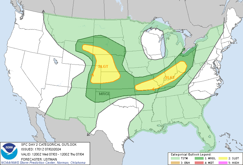
    Tuesday - Slight Risk of severe weather...yes, I understand it's winter but bahhh...I give up with these so called seasons we are suppose to have, anyway... Slight risk of severe weather. Decent storm is going to be kicking out and unlike Spring storms, you don't need CAPE values over 3000 to get a decent show. Looks like instability will be setting up early over Central OK (gradually moving east through the day). CAPE values in some spots could push 1000-1500. EHI values will be decent, but nothing to signify end of the world stuff. LI's are relatively slow, but this time of year still decent. Could see storms start up just North and West of I-44, which the heavier precip in SW OK. Storms will migrate east of I-35 probably by lunch time (give or are take a couple hours).

    SPC is hinting at an upgrade to Moderate for those out in AR, NE TX, and NW LA...possibly far SE OK. This really isn't that out of the ordinary since the Southeast US gets into their severe weather season about this time of year. However, it does seem to be a wee bit further west and well north of the usual areas for this time of year (all the way north into IL and IN).

    It probably won't be a lot for us. Typically early season storms tend to rocket east pretty quickly leaving us views of "what could have been" out on the Eastern horizon as we fall through the cracks in the clay of our yards.

    Click image for larger version. 

Name:	day3otlk_0830.gif 
Views:	101 
Size:	26.4 KB 
ID:	3277

  11. #111
    Uncle Slayton Guest

    Default Re: Oklahoma Weather Discussion - January 2013

    You can go ahead and say it. We're done w/ snow this season,aren't we?

  12. #112

    Default Re: Oklahoma Weather Discussion - January 2013

    You know he can't say that! Lol It will probably snow that second week of March knowing the weather we been having lately.

  13. Default Re: Oklahoma Weather Discussion - January 2013

    Quote Originally Posted by jn1780 View Post
    You know he can't say that! Lol It will probably snow that second week of March knowing the weather we been having lately.
    I was going to say Mid July, but March is probably more realistic.

    Looking long range...looks like more of the same. Some dips in to the 30s/40s and then peaks in the 60s/70s. So annoying. Bugs are starting to come back and I enjoy my reprieve from having to deal with spiders and scorpions.

  14. Default Re: Oklahoma Weather Discussion - January 2013

    Duplicate.

  15. Default Re: Oklahoma Weather Discussion - January 2013

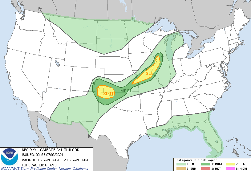
    So of course the month I take out the severe weather images from the front, is the month we have severe weather chances. Sigh.

    Anyway. Risk increasing throughout the day. Looks to be mainly after midnight tonight for Central through SW OK. Maybe late evening today over NE OK. Main risks today are winds, half, and a tornado or two. Yeah...screw the season. LOL

    Everything should still push east of I-35 by Noon tomorrow it appears where severe weather risks increase at a pretty good clip.

    Just keep the weather radios plugged in for this evening in case things get a little crazy.

  16. Default Re: Oklahoma Weather Discussion - January 2013


    DAY 2 CONVECTIVE OUTLOOK
    NWS STORM PREDICTION CENTER NORMAN OK
    1130 AM CST MON JAN 28 2013

    VALID 291200Z - 301200Z

    ...THERE IS A MDT RISK OF SVR TSTMS FROM NRN LA...CNTRL AND ERN
    AR...EXTREME SWRN TN AND NWRN TO WCNTRL MS...

    ...THERE IS A SLGT RISK OF SVR TSTMS OVER A PORTION OF THE SRN
    PLAINS...LOWER THROUGH MID MS VALLEY INTO WRN PARTS OF THE TN AND OH
    VALLEYS...

    ...SYNOPSIS...

    THE HIGH AMPLITUDE UPPER TROUGH NOW OVER THE WRN U.S. WILL ADVANCE
    EWD...WITH MODEL CONSENSUS INDICATING THAT THE TROUGH AXIS WILL BE
    LOCATED FROM MN THROUGH CNTRL/ERN TX BY THE END OF THIS PERIOD. MID
    LEVEL JET AND ATTENDANT VORT MAX LOCATED WITHIN BASE OF THE TROUGH
    SHOULD EJECT FROM THE SRN PLAINS THROUGH THE LOWER-MID MS VALLEY
    TUESDAY NIGHT. AS THIS OCCURS A CYCLONE WILL DEEPEN AND LIFT NEWD
    THROUGH THE MID MS VALLEY REGION. A POLAR FRONT WILL EXTEND FROM THE
    SFC LOW OVER IA SWWD INTO CNTRL/SRN HIGH PLAINS EARLY TUESDAY...WITH
    A PACIFIC FRONT/DRYLINE EXTENDING SWD THROUGH WRN TX. POLAR FRONT
    WILL ADVANCE SEWD DURING THE DAY...WHILE THE PACIFIC FRONT SURGES
    EWD AND MERGES WITH DRYLINE...CONTINUING THROUGH THE LOWER MS VALLEY
    OVERNIGHT.

    ...SRN PLAINS THROUGH LOWER MS VALLEY REGION...

    POTENTIAL EXISTS FOR A SIGNIFICANT SEVERE WEATHER EVENT TUESDAY WITH
    DAMAGING WIND AND TORNADOES THE PRIMARY THREATS...ESPECIALLY DURING
    THE EVENING AND OVERNIGHT IN MODERATE RISK AREA. OBSERVATIONS SHOW A
    RESERVOIR OF MIDDLE TO UPPER 60S DEWPOINTS FROM CNTRL INTO SRN TX.
    SLY BOUNDARY LAYER FLOW ALREADY EXISTS FROM THE SRN PLAINS INTO THE
    LOWER MS VALLEY AND WILL STRENGTHEN TUESDAY IN ASSOCIATION WITH AN
    INTENSIFYING LLJ. WIDESPREAD MULTI-LAYER CLOUDS WILL LIMIT BOUNDARY
    LAYER WARMING DURING THE DAY. HOWEVER...MID 60S DEWPOINTS SHOULD
    ADVECT AS FAR NORTH AS SERN OK INTO CNTRL AR AND NRN MS BENEATH A
    PLUME OF 6.5 C/KM MID LEVEL LAPSE RATES RESULTING IN AT LEAST
    500-1000 J/KG MLCAPE.

    STORMS ARE EXPECTED TO DEVELOP WITHIN PRE-FRONTAL CONFLUENCE BAND
    ACROSS CNTRL/ERN OK INTO NCNTRL/NERN TX EARLY TUESDAY AND SHIFT EWD
    AND NEWD DURING THE DAY. OTHER STORMS MAY DEVELOP FARTHER SOUTH
    THROUGH ERN TX DURING THE AFTERNOON ALONG MERGING PACIFIC FRONT AND
    SHIFT EWD THROUGH THE LOWER MS VALLEY. THE BOUNDARY LAYER WILL
    MOISTEN SUFFICIENTLY FOR THIS ACTIVITY TO BECOME SFC BASED. STORMS
    WILL BE EMBEDDED WITHIN STRONG DEEP LAYER FLOW WITH A 50+ KT SLY LLJ
    AND MID LEVEL WINDS INCREASING TO 80 KT. STORMS ARE EXPECTED TO
    EVOLVE INTO A PREDOMINANT QLCS WITH EMBEDDED SUPERCELL AND BOWING
    SEGMENTS POSING A RISK FOR DAMAGING WIND AND TORNADOES. TORNADO
    THREAT MAY INCREASE OVERNIGHT...ESPECIALLY IN MODERATE RISK AREA
    WHERE LLJ INTENSIFYING TO IN EXCESS OF 70 KT WILL BE COLLOCATED WITH
    NRN EDGE OF MID 60S DEWPOINTS.

  17. #117

    Default Re: Oklahoma Weather Discussion - January 2013

    Not pertinent to any current conditions -- just thought that this was funny:


  18. Default Re: Oklahoma Weather Discussion - January 2013

    We are upgraded to a slight risk for the overnight. Hail, wind and a tornado or two. A few cells have already developed out there. One near Mulhall, another near Guthrie, Cashion, and finally one between Yukon and Mustang. All move NE @ 35 mph.


  19. Default Re: Oklahoma Weather Discussion - January 2013


    MESOSCALE DISCUSSION 0062
    NWS STORM PREDICTION CENTER NORMAN OK
    0929 PM CST MON JAN 28 2013

    AREAS AFFECTED...N-CNTRL OK

    CONCERNING...SEVERE POTENTIAL...WATCH POSSIBLE

    VALID 290329Z - 290530Z

    PROBABILITY OF WATCH ISSUANCE...40 PERCENT

    SUMMARY...ISOLATED TSTMS MAY BE INITIATING WITHIN THE WARM/MOIST
    SECTOR ACROSS CNTRL OK. ENVIRONMENT IS FAVORABLE FOR SUPERCELLS WITH
    ALL SEVERE THREATS POSSIBLE.

    DISCUSSION...A SHORT NNE TO SSW BAND OF ISOLATED SHOWERS HAS FORMED
    IN THE PAST HALF HOUR FROM LOGAN TO NRN GRADY COUNTIES...E OF THE
    SURFACE DRYLINE IN WRN OK. ALTHOUGH LARGE-SCALE ASCENT WAS NOT
    ANTICIPATED TO STRENGTHEN SUBSTANTIALLY TILL AFTER 09Z PER MOST
    MODEL GUIDANCE...IT IS POSSIBLE THAT THIS CONVECTION MAY BECOME
    SUSTAINED AS WEAK MID-LEVEL HEIGHT FALLS OVERSPREAD THE REGION BY
    06Z. EVENING FORECAST SOUNDINGS ALONG WITH MODIFIED 00Z OUN/LMN
    RAOBS SUGGEST MODEST MLCAPE AND MID-LEVEL LAPSE RATES SHOULD PERSIST
    AMIDST A HIGHLY FAVORABLE LOW/MID-LEVEL WIND PROFILE FOR UPDRAFT
    ROTATION. THUS...IF CONVECTION CAN BECOME SUSTAINED...RISKS FOR
    SEVERE HAIL/WIND AND A TORNADO OR TWO WOULD DEVELOP.

  20. Default Re: Oklahoma Weather Discussion - January 2013

    HRRR short term looks like this. Existing activity should remain fairly minimal and continue to move off to the North and East and should end by 1AM.

    Next round fires up in the Panhandles and SW OK around 4AM. Should have a pretty good line that will be near Central OK by 6AM. It will be out of the metro area by 10AM it appears. It is forecasting that the storms should intensify right overhead during this time frame, so the morning commute could be pretty interesting.

  21. #121

    Default Re: Oklahoma Weather Discussion - January 2013

    Of course I washed my car this weekend after not doing so for 3 weeks, and now it rains.

  22. Default Re: Oklahoma Weather Discussion - January 2013

    Quote Originally Posted by Anonymous. View Post
    Of course I washed my car this weekend after not doing so for 3 weeks, and now it rains.
    I washed mine today. Go figure. It's staying in the garage tomorrow. LOL

  23. #123

    Default Re: Oklahoma Weather Discussion - January 2013

    You're both going to face the rath of the people in the water conservation thread. LOL

  24. Default Re: Oklahoma Weather Discussion - January 2013

    Severe risk update for today. For Oklahoma - Slight Risk of Severe Weather for Central and Eastern OK. This includes areas east of a line from Wichita Falls to Lawton to Yukon to Guthrie to Stillwater to just east of Newkirk. Main risk is large hail and damaging winds. There is a tornado threat mainly along and east of I-44. Timing still looks good but may be an hour or two slower than originally mentioned.

    Outside of Oklahoma a severe weather outbreak is expect over much of Arkansas into Southern Missouri, extreme W TN, NW MS, Northern LA, and extreme NE TX. Very large hail, destructive winds, and a few strong tornadoes are expected.

    SPC outlook for Oklahoma...

    ...SRN PLAINS/ARKLATEX/LOWER TO MID MS VALLEY... AN UPPER-LEVEL TROUGH OVER THE ROCKIES WILL MOVE EWD INTO THE GREAT
    PLAINS TODAY AS A POWERFUL 90 TO 110 KT MID-LEVEL JET OVERSPREADS
    THE SRN AND CNTRL PLAINS. AS THE EXIT REGION OF THE MID-LEVEL JET
    CORE MOVES ACROSS THE SRN PLAINS THIS MORNING...THUNDERSTORMS APPEAR
    LIKELY TO DEVELOP FROM SE KS SWWD ACROSS CNTRL OK INTO NORTH TX.
    THIS ACTIVITY SHOULD DEVELOP A SEVERE THREAT AROUND DAYBREAK AS A
    BAND OF LARGE-SCALE ASCENT MOVES INTO THE SRN PLAINS AHEAD OF THE
    APPROACHING UPPER-LEVEL SYSTEM. CONVECTIVE COVERAGE SHOULD QUICKLY
    INCREASE THIS MORNING WITH A SQUALL-LINE DEVELOPING AND MOVING EWD
    ACROSS THE OZARKS AND ARKLATEX REGION THIS AFTERNOON. CONDITIONS
    WILL BE FAVORABLE FOR SEVERE STORMS ACROSS A LARGE AREA AND A
    SIGNIFICANT SEVERE WEATHER EVENT APPEARS LIKELY TO OCCUR LATE THIS
    AFTERNOON FROM SERN MO SWWD ACROSS AR INTO NRN LA.

  25. #125

    Default Re: Oklahoma Weather Discussion - January 2013

    Quote Originally Posted by ljbab728 View Post
    You're both going to face the rath of the people in the water conservation thread. LOL
    The water conservation people should be bowing. A few car washes to bring rain. It's a nice tradeoff.

    I love how mud can fall from the sky in Oklahoma....

Thread Information

Users Browsing this Thread

There are currently 9 users browsing this thread. (0 members and 9 guests)

Similar Threads

  1. Oklahoma Weather Discussion - December 2012
    By venture in forum Weather & Geosciences
    Replies: 408
    Last Post: 01-01-2013, 09:51 PM
  2. Oklahoma Severe Weather Discussion - May 2012
    By venture in forum Weather & Geosciences
    Replies: 141
    Last Post: 06-01-2012, 08:05 AM
  3. Oklahoma Weather Discussion - January/February 2012
    By venture in forum Weather & Geosciences
    Replies: 262
    Last Post: 02-29-2012, 08:04 AM
  4. Oklahoma Fire Weather Discussion 2011
    By venture in forum Weather & Geosciences
    Replies: 17
    Last Post: 06-14-2011, 11:54 AM
  5. Oklahoma Severe Weather Discussion - May 2011
    By venture in forum Weather & Geosciences
    Replies: 377
    Last Post: 06-01-2011, 12:33 AM

Bookmarks

Posting Permissions

  • You may not post new threads
  • You may not post replies
  • You may not post attachments
  • You may not edit your posts
  •  
Single Sign On provided by vBSSO