

Craft beer fest Sat night. Should I be rooting for Saturday morning storms to help my odds of being drunk by 9PM?Originally Posted by Anonymous.


 Participating Member

Craft beer fest Sat night. Should I be rooting for Saturday morning storms to help my odds of being drunk by 9PM?
Participating Member

Looks like it will be getting busy starting Friday. SPC had several days outlined this morning.
 Participating Member
This has the potential to be our most active severe weather period in years.
Participating Member
More active than past two years at the very least. Its hard to take a forecast seriously 6 days out, but Monday and Tuesday look especially big. Still need to get past Friday and Saturday first though.
Participating Member
SPC has added a 30% probability on Day 4 (TX PH and far W OK). This will likely show up as moderate risk in the initial 3-day batch that we will see tomorrow.
SPC is also outlining 15% probabilities now for the following week that I mentioned yesterday. There is two distinct days of sharp dryline showing up consistently. SPC placing 15% risks on the 7 and 8 day outlooks is relatively rare. Confidence is decent a week out from the event.
Participating Member
I wouldn't really make any plans for Saturday evening at this point in time. This has high potential to be one of "those" days for OKC. Next Tuesday as well.
Participating Member
I don't think anyone has to cancel plans. Just stay weather aware and get indoors when you need to.
Gold Member
Ya I am just parking in a parking garage. No changing plans other than that.
Participating Member
Hard to gauge tornado threat this far out. but, you can bet the flooding risk is high with all this rain we have been receiving this year.
Participating Member
The stormchasers discord hasn't been this excited in years. To me that's usually a bad sign for weather lol.
Participating Member
And the dryline looks to be setting up in just the right place...from around El Reno down to Chickasha. Farther west and it's usually a squall line or MCS by the time it gets here and farther east means most of the severe is east of I-35. We can't know for sure until around the 48 hour window (or maybe even the day of) but this could end up being a very classic PDS setup for OKC.
Participating Member
Or when Rick Smith from NWS starts quoting twister.
https://twitter.com/ounwcm/status/1128271452376113153
To be clear though to those who don't know, stormchasers are excited by the number of consecutive days in a row that they will get to chase which increases their chances. Not that one day in particular will be exceptionally bad, although we could get one of those days with this series of storms.
Edit: Looking at a forecast sounding for Monday would seem to apply that will be a TDS day. Again, way out in the future.
Participating Member
New Kids on the Block mixtape tour Saturday night. Damn right I'll be there.
I think I’ll watch the tornado coverage
Participating Member
Dry line looks through the Metro by 7 so maybe east of OKC. Plus storms in the Morning. Looks messy for Saturday still. Monday is the day.
Participating Member
It doesn't look like the "historic" week like it did yesterday. Still active, but not a slam dunk like people were talking about yesterday.
Banned
Awe, darn. We waited a day, and everything changed. I am kinda glad, since I move into my new house this coming week.
Participating Member
Glad to hear my all you can drink craft beer odds are looking better for Saturday night.
Participating Member
Yep Now we are getting into the IF stage. IF storms can fire on Friday. IF Storms don't linger too long Saturday morning. IF IF IF. It was mass Panic on Tuesday. Now Wednesday we are at the IF stage and everyone seems to be backing off some
Participating Member
Now we have gone from Doom and Gloom on Tuesday to If's on Wednesday to well the timing isn't right on Thursday and thing might not line up. I would imagine tomorrow we will be at the storm was weaker or moved a different direction.
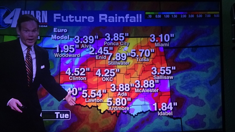
It's projected to be a big rain event for the state from Fri. to Tues. with Stillwater taking the most. I'll believe the hype when I see it.
May 23-29 doesn't look cool and dry.

Participating Member
Grocery stores will be disappointed, they need more end of days type forecasts lol. I always wondered if weathermen and grocery stores worked in tandem. I imagine the discussion goes like this: “If you push higher snow fall or big bad tornadoes we’ll give you 20% take of the increased sales”
Participating Member
Not sure I'm going out to by groceries before a tornado just to have the tornado wipe them away. But yeah maybe a generator for a big thunderstorm. Looks like Friday the CAP holds
Participating Member
Friday looks like event zone will be extreme W OK. Saturday looks like still a good shot at storms from SW to C OK. This may be a giant MCD coming up out of NW TX.
Monday SPC has moved to a 30% probability inside the original 15. This does include a large swath from C OK into NW TX.
Looks like maybe some action still around Wednesday too.
There are currently 1 users browsing this thread. (0 members and 1 guests)
 Posting Permissions

 Reply With Quote
Bookmarks