


So starts the April 2017 weather discussion thread.
Tomorrow's Severe Weather Outlook


So starts the April 2017 weather discussion thread.
Tomorrow's Severe Weather Outlook
If you happened to have recently tried to use wunderground's network of streaming NOAA weather stations to hear the Oklahoma City station, then you know it's down. Wunderground has permanently discontinued it. However, in response, a voluntarily created network of streaming NOAA weather stations has arisen. The Oklahoma City NOAA station, along with two other Oklahoma stations can be heard on it - Bartlesville and Stillwater. Hopefully, the network can handle increased load when severe weather demands it. The list of stations currently available to be heard from all over the county can be accessed here: http://noaaweatherradio.org
Any word on why they discontinued it? Lack of use? Expense? Didn't wunderground get bought up by one of the big media grunts recently?Originally Posted by Bunty

EDIT Just went to the wundergound page where they announced this and their "reason" was just corporate doublespeak. Sounds like a *lot* of the nice things wunderground did are quietly getting shuttered. Shame. Once again, the weather consumer is the loser.
 Participating Member

Wunderground is part of The Weather Company, which is part of IBM. It's been at least a couple of years since they were purchased by Weather Company, but not sure exactly how long.
Wunderground was bought by The Weather Channel in 2012. IBM bought what amounts to all the "mobile web" assets of TWC in 2015. Wunderground is also discontinuing severe weather SMS alerts and their aviation forecasts. That tells this naive soul that either they're trying to force that audience to a different target that monetizes better, or that target *doesn't* monetize well and are leaving it to local broadcasters (like our local stations) or local weather forecast offices - or perhaps that mobile "audience" is already changing and isn't reacting to things like push notices, etc as was expected. Who knows.
I also recall that Accuweather was, ultimately (and, I guess 'allegedly') behind a congressional lobbying push to essentially shutter NOAA (perhaps not completely but practically) and (conveniently) let Accuweather just sell that kind of met service to whomever wanted it.
Anyway, sorry for a bit of the thread derail: ) Here's to a quiet April in Oklahoma.
Participating Member
Whoa. Tell me more - I'm very curious.
 Participating Member
Looks like severe weather may be on the uptick for tomorrow things are a changing.....
Participating Member

Very compact system coming across the state tomorrow. Some remnant cells coming out of the TX PH tonight, will slowly die as they head east into OK - may reach NC OK, possibly some early morning OKC rain if they hold together.
Then tomorrow is the weird forecast of instability either being there or not when the low travels directly across I-40 and then up I-44. This will allow for some weird dynamics along and just north of the center of the low. So anywhere from WC to C and N OK will have to keep an eye out. And of course all of eastern OK will be in play for late afternoon severe weather, likely a line of storms. Will update in the morning of course.
Participating Member
Short range models showing development this evening basically right over C OK and pushing to the north and east. Severe potential will likely be with any tail-end cells that fly northeast with the spin of the low. Meanwhile, these storms will later mature and become more numerous as the system pushes east - which will place NE OK in an elevated threat area.
The OKC play is very hit-or-miss. Best shot is northern sides of the metro. It will really matter how far NW the warmer, unstable air makes it across OKC.

I wish I could remember more of the details, but IIRC there was some legislation going around a while back that basically advocated privatizing several agencies, but NOAA was the real target. Somewhere along the way, Accuweather (or whomever owned it then?) was supposedly identified as a big supporter of the bill. I realize that's pretty vague, but that's what I remember. Heck, our old friend Venture (who really started all this severe weather watching here at OKCTalk several years ago) may have discussed it some. If I can find more info, I'll start a separate thread so we don't clutter this one up
We now return you to your regularly scheduled April weather thread
Participating Member
SVR Watch issued.
230 PM CDT Tue Apr 4 2017
The NWS Storm Prediction Center has issued a
* Severe Thunderstorm Watch for portions of
Northwest Arkansas
Southeast Kansas
Southwest Missouri
Central and Northeast Oklahoma
* Effective this Tuesday afternoon and evening from 230 PM until
900 PM CDT.
* Primary threats include...
Scattered large hail and isolated very large hail events to 3
inches in diameter possible
Isolated damaging wind gusts to 70 mph possible
A tornado or two possible
SUMMARY...Scattered severe thunderstorms are expected to develop
over central Oklahoma by 4pm. This activity will spread/develop
northeast into portions of southeast Kansas and southwest Missouri
and northwest Arkansas. Large hail and damaging winds are the
primary threats, though a tornado or two could be noted with the
strongest activity near the I-44 corridor.
The severe thunderstorm watch area is approximately along and 60
statute miles north and south of a line from 5 miles southwest of
Oklahoma City OK to 15 miles east of Monett MO. For a complete
depiction of the watch see the associated watch outline update
(WOUS64 KWNS WOU1).

Participating Member
Storms exploding right now. Notable storms are west of Kingfisher, directly over eastern OKC, and east of Shawnee.
Participating Member
No streaming radar or information. But the chat is here if anyone wants to follow along while these are near OKC.
http://www.weatherspotlight.com/live-chat/
Participating Member
OKC is likely out of the woods for the big time stuff. The unstable air just never made the push far enough to the west.
NW OKC up towards the Piedmont area may get clipped by the cold-core convection as it tries to build south just west of OKC, but I wouldn't hold my breath.
Meanwhile, if you know someone in Tulsa - tell them to maybe think of leaving work early. Rush hour up there will likely be a nightmare.
Severe thunderstorm watch for OKC canceled. Storms moved by fast. Just .15" here with no hail. Some places did get hail.
Participating Member
Should we see any rain overnight? I put down some fertilizer for the lawn when the clouds were out this afternoon, but we didn't get any rain.
Participating Member
Next chance for Severe Weather comes Late Sunday afternoon into Sunday evening. Should be dry till then.
Participating Member
We will likely see the 3rd SPC High Risk of the year, #2 of the week, on Wednesday.
This year is the first since 2014 for the High Risk category to return. If you recall, the 5-count category risk system began in fall of 2014, so it is (conceivably) more difficult to reach High Risks.
Sorry to be dense, Anon, but do you mean Wednesday (4/5) with a possible upgrade of the current MDT region in the SE US to HIGH in the SE US, or do you mean here in OK NEXT Wed (4/12)? I kept going back and forth on what you meant but finally decided to ask
I've not been a fan of the new five-category system ever since it was released, as I think the terms delineating the various risk levels are improperly chosen...
Participating Member
I had the same question, but didn't bother to ask.
Agree 100% ... I don't think it's intuitive to the average layman.
Participating Member
Oh sorry. No you wouldn't ever catch me predicting a risk that is 8 days away!
I am speaking of the eastern parts of the country. Specifically out near central and eastern Tennessee/Kentucky. I am expecting an upgrade in risk - but it appears they may leave the large blanketed Moderate due to questionable instability with on going convection.
I didn't think so, but I could never quite convince myself either way
Yeah I was reading the SPC outlook for that area and that's really a potential boiling pot for today.
I have sent an email to the SPC explaining to them why I think their terminology scale is fundamentally flawed - a "slight" risk is higher than a "marginal" risk, and a "moderate" risk is higher than an "enhanced" risk - that's just wholly counterintuitive. For as long as I can remember, "slight" has been used to characterize a minimalist probability of rain, and the word "moderate" on its face implies mitigation. I think they need to either reorganize that list of words or go to an exclusively percentage-based scale.
They may have had valid reasons within the meteorological community to have developed that word scale as they did, but in my opinion they left out a key ingredient - remember your audience. How they intended the words to be used isn't nearly as important as how the reader decides to interpret them.
Participating Member
Yeah, the slight/enhanced/moderate/high wording is confusing if you don't know what each risk level means.
People tend to not take slight risks seriously while they tend to lose their minds over anything moderate and above. I think the best way to do risk categories, if it was possible, would based off how high-end it could possibly get. For instance, if the ingredients are in place for violent EF4+ tornadoes and/or baseball or larger hail, that should be a high risk. If it's more of a wind and small hail threat with the possibility of an isolated weak tornado, that would be a slight risk.
Participating Member
RE: wording/ordering on the Convective Outlook product suite...
This tweet and related thread should be of interest:
https://twitter.com/StuOstro/status/849321537958227969
There are currently 1 users browsing this thread. (0 members and 1 guests)
 Posting Permissions


 Reply With Quote
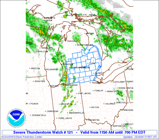
Bookmarks