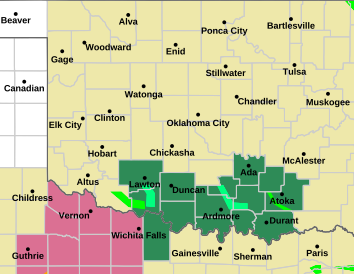
I'll start the January weather thread with a winter storm watch. It includes all the OKC metro area.
WINTER STORM WATCH
Areas Affected:
Atoka - Bryan - Caddo - Canadian - Carter - Cleveland - Coal - Comanche - Cotton - Garvin - Grady - Hughes - Jefferson - Johnston - Kingfisher - Kiowa - Lincoln - Logan - Love - Marshall - McClain - Murray - Noble - Oklahoma - Payne - Pontotoc - Pottawatomie - Seminole - Stephens - Tillman - Washi ta
Effective: Wed, 1/2 6:00am Updated: Tue, 1/1 11:38am Urgency: Future
Expires: Fri, 1/4 6:00am Severity: Moderate Certainty: Possible
Details:
...Winter Precipitation Likely Wednesday and Thursday...
...WINTER STORM WATCH REMAINS IN EFFECT FROM WEDNESDAY MORNING
THROUGH LATE THURSDAY NIGHT...
* WHAT...Heavy mixed precipitation possible. Total snow
accumulations of 3 to 6 inches and ice accumulations up to
around two tenths of an inch possible. Though most of this is
expected to fall Wednesday night and Thursday... minor impacts
will still be possible on Wednesday.
* WHERE...Portions of western, central, and southern Oklahoma and
northern Texas.
* WHEN...From Wednesday through early Friday.
* ADDITIONAL DETAILS...Travel could be very difficult. The
greatest impacts are expected Wednesday night through Thursday
night.
Information:
A Winter Storm Watch means there is potential for significant
snow, sleet or ice accumulations that may impact travel. Continue
to monitor the latest forecasts.
Counties covered in blue:


 Reply With Quote

Bookmarks