Widgets Magazine
Page 1 of 17 123456 ... LastLast
Results 1 to 25 of 408

Thread: General Weather Discussion - May 2019

  1. #1

    Weather General Weather Discussion - May 2019

    A small round of storms expected to develop across W and NW OK by morning. May clip the OKC metro from the west. Otherwise, mostly an event for SW and S OK from the looks of it. However, storms will ride outflow boundaries and predicting where they develop and how far is nearly impossible.

    After that we will have a break until likely late Friday night we have another round come up from NW TX and impact the state.

    Looking even further out we will have some chances of more storms Sunday night and looks like again early next week.

  2. #2

    Default Re: General Weather Discussion - May 2019

    Some forecasts are showing storms Friday morning, would you agree with that?

  3. #3

    Default Re: General Weather Discussion - May 2019

    Yes for C OK, we should see spotty showers and storms develop right around sunrise. Then likely a break in the action until later when a larger cluster organizes across W/NW OK and slides to the SE in the afternoon. Exact timing of everything could shift by hours depending on when storms actually initiate.

  4. #4

    Default Re: General Weather Discussion - May 2019

    Line of storms in N/NW OK is slowly building east. We will see development of showers and storms ahead of this complex as we head into the afternoon hours. Eventually everything will sweep off to the SE as we head into the evening. Heavy rain and flash flooding is the main threat.

  5. #5

    Default Re: General Weather Discussion - May 2019

    Any guestimate as to when the rain will be over? Lyric Theater is having an outdoor event in the boathouse district (which everyone should go to! http://broadwayandbrew.com/) this evening and I'm hoping the rain won't cause serious issues.

  6. #6

    Default Re: General Weather Discussion - May 2019

    Quote Originally Posted by Timshel View Post
    Any guestimate as to when the rain will be over? Lyric Theater is having an outdoor event in the boathouse district (which everyone should go to! http://broadwayandbrew.com/) this evening and I'm hoping the rain won't cause serious issues.
    My guess is for C OK majority of rain is over by 6-7pm.

  7. #7

    Default Re: General Weather Discussion - May 2019

    Any news on Sunday? Last I heard, there was a small chance for large storms. Any new data coming in suggesting otherwise?

  8. #8

    Default Re: General Weather Discussion - May 2019

    Quote Originally Posted by C_M_25 View Post
    Any news on Sunday? Last I heard, there was a small chance for large storms. Any new data coming in suggesting otherwise?
    The main storm threat tomorrow should be in Western OK. There may be some morning storms in the OKC area but I wouldn't expect them to be severe.

    Wednesday is looking like the biggest severe weather threat for the Metro at this time, but it's still several days out so all can change.

  9. #9

    Default Re: General Weather Discussion - May 2019

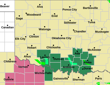
    Severe thunderstorm watch 137 is in effect until 400 am cdt
    Counties affected: Beckham; Caddo; Canadian; Cleveland; Creek; Grady; Greer; Kingfisher; Kiowa; Lincoln; Logan; McClain; Nowata; Okfuskee; Oklahoma; Okmulgee; Osage; Pawnee; Payne; Pottawatomie; Rogers; Seminole; Tulsa; Washington; Was hita

    Areas affect in dark pink:


  10. #10

    Default Re: General Weather Discussion - May 2019

    Storms approaching C OK now. Likely will be severe by the time they impact OKC from the W and NW. Heavy rain is main threat. Perhaps some small hail, but damaging hail is unlikely.

  11. #11

    Default Re: General Weather Discussion - May 2019

    Still three days out, a more classic dryline type of event Wednesday. SPC mentioned higher probabilities may be needed.

    Attached Thumbnails Attached Thumbnails Click image for larger version. 

Name:	interstate.gif 
Views:	86 
Size:	11.8 KB 
ID:	15281  

  12. #12

    Default Re: General Weather Discussion - May 2019

    We should see some storms pop up this Monday afternoon across SW KS and in toward the Panhandle area. At this time, it looks like these will form a line and move across NW OK and into S KS. However, we could see some southern-edge back-build that brings additional areas under the gun. Will monitor.

    Tuesday looks like severe storms will develop out in the pandhandle and form a squall line as it enters W OK. Storms will begin to dissipate as it will be well after dark before storm chances reach C OK.

    Wednesday will be determined based on Tuesday night's storms. But at this time we may see development just west of C OK along the I-35 corridor. Full storm maturity may be achieved by the time any supercells are entering the OKC area. This will likely be a 'Moderate' risk day for a decent portion of OK. Large hail will be primary threat, with tornado threat accompanying any discreet cells that develop off the dryline.

  13. #13

    Default Re: General Weather Discussion - May 2019

    NWS currently going with Slight risk and very low tornado potential for Wednesday.

  14. #14

    Default Re: General Weather Discussion - May 2019

    FLOOD WATCH--Does not include Oklahoma City:

    Details: ...FLOOD WATCH IN EFFECT FROM 7 PM CDT THIS EVENING THROUGH
    WEDNESDAY MORNING...
    The National Weather Service in Norman has issued a
    * Flood Watch for flash flooding...flooding of creeks and
    rivers...and flooding of low lying areas for portions of
    central Oklahoma, northern Oklahoma, northwest Oklahoma, and
    western Oklahoma, including the following areas, in central
    Oklahoma, Kingfisher, Logan, and Payne. In northern Oklahoma,
    Garfield, Grant, Kay, and Noble. In northwest Oklahoma,
    Alfalfa, Blaine, Dewey, Ellis, Harper, Major, Woods, and
    Woodward. In western Oklahoma, Custer and Roger Mills.
    * From 7 PM CDT this evening through Wednesday morning
    * Rainfall amounts of two inches or more are possible. This
    rainfall on top of the already wet soils will lead to runoff and
    flooding, especially of low lying and poorly drained areas.
    * Do not drive through flooding roadways. This is especially
    dangerous at night.
    Precautionary/preparedness actions...
    A Flood Watch means there is a potential for flooding based on
    current forecasts.
    You should monitor later forecasts and be alert for possible
    Flood Warnings. Those living in areas prone to flooding should be
    prepared to take action should flooding develop.

    Area covered in green:


  15. #15

    Default Re: General Weather Discussion - May 2019

    Severe weather ongoing out in the panhandles currently as forecast. These should form a line and push east as we head into the evening. The storms may very well begin to lose steam as they approach C OK around midnight. However, could still be severe - especially with wind gusts from any bow echo portions of the cluster.

    As of now, it looks like the speed of the low's movement will actually increase, thus not giving the atmosphere plentiful time early Wednesday to be favorable for development of severe storms in C OK. So as of now, SPC will maintain a slight risk for Wednesday, but we may not see any storm development at all. The dryline is forecast to move from W OK through C OK sometime early evening, which will be the focal point of any development Wednesday afternoon. So just stay updated, but as of right now it does not look likely.


    Snapshot of storms coming in late Tuesday night:

  16. #16

    Default Re: General Weather Discussion - May 2019

    Ahead of the line, we have storms bubbling up randomly here in C OK. Atmosphere has a lot of lift right now so little organization or direction with these. At this time not severe, but strongest cell currently moving S to N thru western parts of Norman. We will have to watch for discrete cells that begin rotating. Large hail and isolated tornadoes are possible with any dominant storms.

    Tornado Watch likely coming in the next hour for all of C OK.

    Storm-spin parameters are pretty ideal right now across the area.

  17. #17

    Default Re: General Weather Discussion - May 2019

    TORNADO WATCH INCLUDES OKC METRO

    Updated: Tue May-07-19 09:11pm CDT
    Effective: Tue May-07-19 09:15pm CDT
    Expires: Wed May-08-19 05:00am CDT

    Severity: Severe
    Urgency: Expected
    Certainty: Likely

    Status: Actual
    Type: Alert
    Category: Met
    Areas affected: Alfalfa; Beckham; Blaine; Caddo; Canadian; Carter; Cleveland; Comanche; Cotton; Creek; Custer; Dewey; Garfield; Garvin; Grady; Grant; Greer; Harmon; Jackson; Jefferson; Kay; Kingfisher; Kiowa; Lincoln; Logan; Major; McClain; Murray; Noble; Nowata; Okfuskee; Oklahoma; Osage; Pawnee; Payne; Pontotoc; Pottawatomie; Roger Mills; Seminole; Stephens; Tillman; Washington; Was hita

    Counties in yellow affected:

  18. #18

    Default Re: General Weather Discussion - May 2019

    I would say we can check if venture's chat is running for easier information sharing, but I cannot even remember the URL. weather spotlight or something like that?

    EDIT: found the old link, looks like it is no longer a valid domain.

  19. #19

    Default Re: General Weather Discussion - May 2019

    Storm cell west of Norman and east of Newcastle is exploding upward right now. Hail signatures coming up.

    Cell NW of Carnegie also coming up decently.


    9:53pm EDIT: Cell coming into Moore and out of Newcastle/Nroman area is now severe warned. Right now it is looking like the healthiest cell ahead of the cluster.

  20. #20

    Default Re: General Weather Discussion - May 2019

    Here is the correct URL for his site: http://www.wxstuff.com/index.php?r=d...rd%2Fdashboard

  21. #21

    Default Re: General Weather Discussion - May 2019

    Quote Originally Posted by Bobby821 View Post
    Here is the correct URL for his site: http://www.wxstuff.com/index.php?r=d...rd%2Fdashboard
    Oh nice! Good find. Here is the link to the chatroom if anyone wants to chat, we won't have control over the screen-streaming, but better than posting in the forum.

    https://chatroll.com/embed/chat/wxst...tuff-live-chat

  22. #22

    Default Re: General Weather Discussion - May 2019

    Nice downpour at my place a few miles north of Downtown. No hail, not too much lightning.

  23. #23

    Default Re: General Weather Discussion - May 2019

    Quote Originally Posted by SEMIweather View Post
    Nice downpour at my place a few miles north of Downtown. No hail, not too much lightning.
    Cool site shows lightening strikes. Click on Texas and it covers Oklahoma too

    http://en.blitzortung.org/live_light...aps.php?map=31

  24. #24

    Default Re: General Weather Discussion - May 2019

    Northern half of the line of storm is gusting out ahead of itself. This will accelerate the arrival of storms for roughly the northern half of I-35 corridor. And the southern edge will lag behind some. Cluster likely to take on a backwards S shape and move east as one unit.

    This will result in the most severe portion of the cluster being the southern half. I would say from Norman and south will be the more dangerous parts of the line.

    Flash flooding and initial gust front will be the main threat. Small tornado spinups are possible ahead and just in front of the line, but like I mentioned - SC OK will be the main focus.


  25. #25

    Default Re: General Weather Discussion - May 2019

    News9 Val Caster has live footage of tornado north of Hobart and now 10 miles north nw of it now heading to Cordell

    Wow, 2 of them on ground a mile away from each other

Thread Information

Users Browsing this Thread

There are currently 1 users browsing this thread. (0 members and 1 guests)

Similar Threads

  1. General Weather Discussion - April 2019
    By Anonymous. in forum Weather & Geosciences
    Replies: 102
    Last Post: 05-02-2019, 10:52 AM
  2. General Weather Discussion - March 2019
    By Anonymous. in forum Weather & Geosciences
    Replies: 82
    Last Post: 03-30-2019, 02:18 AM
  3. General Weather Discussion - February 2019
    By Anonymous. in forum Weather & Geosciences
    Replies: 118
    Last Post: 02-28-2019, 07:02 AM
  4. General Weather Discussion - January 2019
    By Bunty in forum Weather & Geosciences
    Replies: 108
    Last Post: 01-30-2019, 09:55 PM
  5. General Weather Discussion - May 2017
    By Anonymous. in forum Weather & Geosciences
    Replies: 201
    Last Post: 06-03-2017, 05:36 PM

Bookmarks

Posting Permissions

  • You may not post new threads
  • You may not post replies
  • You may not post attachments
  • You may not edit your posts
  •  
Single Sign On provided by vBSSO