

I went to the store this morning to get a few things for chili, it was completely stocked.
They were wiped out yesterday but they were restocking as they got a truck this morning. Nothing better than a fully stocked store with fresh product with very few customers.


The first substantial freezing rain batch (that will impact OKC) is developing now over Lawton.
In your guys' opinions, how will we be looking tomorrow night at about this time? I've got a bunch of friends that were going to come hang out tomorrow at 7pm for my birthday but I'm trying to figure out if I should postpone those plans due to the expected impacts of the ice.
The only thing about this type of weather is that it doesn't show up on RadarScope Pro. Kinda dissatisfactory...


Yes, it will be here in the next hour or two. The midnight stamp is the beginning of the most lift as the storm really gets moving out of the west. This is when the most convective showers will develop along I-44. The heavy waves could last all night into the late morning hours (and probably later).
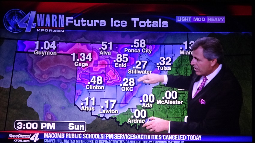
WOW, KFOR's Mike Morgan thinks ice will be over an inch in parts of NW Oklahoma.


^^ Yes NW OK will see a historical storm.
Main precipitation train is in its infancy down in NW TX. Slowly developing and lifting north.

Road temps appear to be holding on a least a bit longer. Grass behind my house is icy, but the back patio and street in front of the house are still just wet (SW OKC)


It's been below freezing since yesterday in OKC so I would have to think streets are near freezing now.


It's been below freezing since yesterday in OKC so I would have to think streets are near freezing now. It looks to me like any meaningful freezing rain should be in OKC metro between 1-2:00 am. This is according to what the radar is showing.


Just checked some other future casts and they're all matching up with what anon and others have been posting. Looks like around 1-2 AM CT is when the first SIGNIFICANT boundary starts to actually take form and start pushing through the state.
I know there's a lot of ranches and farms, etc. out in the Western part of the state. Gonna be praying for them to make it through Sunday when it warms up.
For what its worth, the latest runs of the HRRR (hi-res model that runs hourly) have been initializing very poorly compared to what radar has had so far. That isn't to say the heavier stuff won't develop as forecast tonight, but it hasn't been doing amazingly well so far.


Looks like it's starting to crank up to the south now heading our way.
Really coming down in Lexington right now.


Looks at watch... Looks at radar...

Fortunately, the ice storm isn't shaping up to be as bad as hyped. As of 3:24 am the NWS forecast for OKC said to expect ice accumulation of around .1" overnight and an additional accumulation of less than .1" before noon then rain showers.
The forecast is the same for Stillwater. In Stillwater, at 4:30 am with a temperature of around 30 after hours of light freezing rain, sometimes briefly moderate, the streets and sidewalks remain wet as before. Everything else is lightly coated with ice.


Yep, fortunately. The last future model I had checked basically had solid swaths across the state. I check this morning and it's still a broken up system more or less - very spotty.
Perhaps we dodged one here, although we still have later today to go through, I'm hoping we begin to thaw out without much accumulation.
About 1/16" of an inch here in NW OKC, with not a whole lot more to our SW.
There are currently 2 users browsing this thread. (0 members and 2 guests)
Bookmarks