

My guess would be that it runs one direction on one street and the goes back the other way a block over instead of double track. Pretty much a really tight loop, like the northern part of the Portland track.

 Participating Member

My guess would be that it runs one direction on one street and the goes back the other way a block over instead of double track. Pretty much a really tight loop, like the northern part of the Portland track.
VIP Member

But it only does that in downtown Portland because of the one-way streets. In the areas where the streets are two-way it is double tracked in the same street. I guess it could also refer to the integration to their light-rail that runs at a 90 degree orientation to it.Originally Posted by stdennis

Urban Pioneer - what does 'couplet' mean?
Participating Member

I'll give my definition and Urban Pioneer can correct me if I'm wrong. A couplet simply means that your two lines of streetcar are separated by at least a block and run parallel to each other. One line runs one direction and the other runs the opposite direction. It does not really relate to the presence or absence of one-way streets. I'm not sure if there's a maximum distance apart a couplet can be, because at some point, if your lines are far enough apart block-wise, it in essence becomes a loop instead.
The good thing about a couplet is that it spreads development out farther. In addition, it makes access to a line easier for people who've left the immediate streets on which the streetcar runs. If the lines run perfectly parallel to each other, there's really not much more confusion about where to pick up the streetcar than if a street is double-tracked, and the single lines create less congestion on each street than a double line would. Or, at least those are reasons I think couplets are good.
Participating Member
The problem I would see with going up and down Robinson is it is only four lanes. Now, assuming Project 180 will convert Robinson to a two way street, either the curbside parking would have to be removed or the streetcar would block traffic at stops along the street. If it were on Broadway, up until fourth street, it would be six lanes, then five lanes with curbside parking (essentially seven lanes.) Taking one lane out on Broadway would not be as big of a deal as on Robinson.
VIP Member
In that case Betts - the only reason Portland went that route was because of the one-way streets. They didn't do it becasue they wanted to, they did it because they had to. Otherwise, they would have the street car running head first into traffic. After Project 180 OKC won't have one-way streets. It also works well in Portland because they have very small blocks (less than half the size of an OKC block). I checked the Toronto system and all of the system I saw was double track. In fact, every system I have seen so far (other than Tampa) has used double track when they can.
Participating Member
But Kerry, let's pick Broadway as an example. You could double track Broadway. Because of the width of our blocks, as you said, people over on Harvey or Hudson downtown would have to walk two to three long blocks just to get to the streetcar, whereas if Robinson were the couplet to Broadway, they'd only have to walk one or two blocks. Couplets open up a much broader piece of the city to development AND make it easier to be within a reasonable distance from a line. In my imagination, the perpendicular streets between the couplets, because developers will also know with certainty that people will be walking on them, are also more attractive for development. It creates a type of pedestrian mall concept, without moving access for cars.
I'll let Urban Pioneer comment, but I believe he's said that Portland really likes the couplet system, now that it's had a chance to try it.
VIP Member
Project 180 is being undertaken to undo the damage caused by one-way street. Now you want to apply the one-street model to the street car. That seems counter productive. Toronto has larger blocks than us and they use double track. The solution is not divide up the tracks, it is to make more lines. Double track Broadway in phase 1 and double track Walker in phase 2.
Participating Member
I'm going to have to agree to disagree with you Kerry, for precisely the reasons I've outlined. One way streets are an unrelated issue, IMO, and spreading out development and ease of access to the streetcar are more important, to my way of thinking.
Participating Member
I'm not sure if I can address all of this on my phone screen. Lol. Both Kerry and Betts are both right. Portland did do a "couplet" because of one way street flows. However, the unintended positive result was the creation of a "transit mall". The development impact was spread out directly by an additional block. It also helped encourage "walkability" as people have to walk a block to pick up the line going in the opposite direction. So if anything, it is a perception issue to a pedestrian encountering the line. Portland now does couplets in their expansions irregardless of one way streets. The locals have it trained in their minds to simply walk a block over to catch it. That is why stops are on parallel corners on opposite blocks.
In a practical design here, seemingly everybody agrees that Broadway needs to be served. But north bound on Broadway is difficult. A right hand turn off of Sheridan to go north is extremely difficult because the Renassiance hotel abuts the corner and the streets, sidewalk, and median areas are tight. There is a large Trigon vault in the way. Then you get the the infamous 3rd/EK Gaylord intersection where there would obviously be a forceable "kink" in the line to make that turn. All these things can be overcome. But it will cost more and be a "twisty / turny" ride. Every turn you make slows down the system. The tighter the turn, the slower it gets. And I can nearly guarantee you that the wheels will squeel trying to make that tighty in front of the hotel. So our committee considers all of these things including how many extra drivers and trams are needed to overcome "slow downs" in the system to maintain the 10 minute demand time. More "kinks" means more operational cost which means shorter track to meet both the MAPS budget and the operational budget.
Southbound Broadway, no problem!!! At least none that we know of yet. A nice quick and gentle left hand turn off of Broadway onto Sheridan without squeeling wheels. No crazy 3rd street intersection as your skirting past it in front of TAP architecture. No necessary shift on 4th street.
Now a northbound Robinson... Robinson is beautiful in that it is uniterupted by "super blocks". You can easily expand to Capitol Hill or end up to the Paseo through Jefferson Park. The southbound Broadway line can merge into a "double track" configuration at N. 16th/17th streets. Essentially you end up with what Portland has discovered unitentionally ideal, a "transit spine or transit mall". Regarding the narrowing of Robinson via P180, we are going to assess that. Warren, you may be right and it may neccessitate a area in front of the streetcar to "pull over" in front of each stop. But it can be done.
There are some things to think about. If Broadway was the spine would future commuters want to dropped of from the hub in front of the Skirvin? I would argue that Park/Robinson is so centralized to the CBD, that getting people directly to this point they can walk to their office from, is a essential consideration as it relates to the future commuter system. It will be the "Pioneer Square" stop of the future as more things come online.
Also, if you look at intuitiveness, as it relates to the pedestrian grade, Robinson is at the crest of the hill. It is definitively so from the Memorial to 10th street. It is somewhat so at 4th. It is at the bottom at 3rd. And level at RS Kerr, Park, Sheridan, Reno. Harvey is actually the best street at 3rd / 4th. But Robinson is a great compromise over the entire N/S length.
The whole "mall" idea has other purposes. First National has a pedestrian mall from Broadway to Park. A stop at either end facillitates a covered and protected connection between blocks. Those buildings that Sand Ridge is tearing down will uncover direct connection at both Robinson and Broadway to the Conncourse Underground system. It they felt inclined, they could put NY style escalator bays directly down to the Conncourse with covered stops for the streetcar for their employees as part of their plaza plan.
Finally, for this "mall" type concept to fully and easily work, it means new sidewalk connections between stops between N. 6th and 13th streets. Decorative, intutive inlays or pavers further identifying the connection.
There are certain streets that make sense for double tracking. Sheridan may, the new Boulevard, 13th. But Broadway all the way through is not one of them. If anything, simply because of the kinks.
Also, I think it is extremely important that these be straight lines on a map to start with. No twists or turns on main "spines". It has to be intuitive to the 1st time user. It has to be easily explained verbally when giving directions. It has to be perfect.
Participating Member
One other debate item about Robinson. It is my gut feeling that it will be easier to get support from people on Heritage Hill East to go up Robinson to get to 23rd and head for the Paseo, than it would be to go straight up Walker. It's wider, it used to have a streetcar, and quite frankly I think the people over there won't mind such change as much. The same might be said about Shartel through Mesta Park. My gut feeling though is that Walker would be tough.
Now maybe after a Phase one and they actually saw it and heard that it makes very little noise, it might be different.
Participating Member
Moving to all two-way streets with Project 180 and using couplets gives a lot more flexibility with choosing streets. Obviously, the lines do need to be on the right side of the street. So southbound on Robinson, i.e., west side of Robinson with northbound on Broadway means east side of Broadway. But as Urban Pioneer has pointed out, that configuration gets messy, especially at Sheridan and Broadway and 3rd and Broadway. Conversely, north on Robinson (east side) and south on Broadway (west side) is a lot simpler and also minimizes the distance between the lines to just the distance within the block. Our blocks are notably wide and avoiding having to cross Broadway (a notably wide and busy street) to get to the other stop for the other direction will help.
Another very useful benefit of one line per street is that allows the utilities to be more easily located on one side of the street with the streetcar on the other. Given that utilility relocation is the most expensive, complicated and risky (in terms of unknowns and delay) of a streetcar project then this is a non-trivial consideration.
One very important thing to keep in mind here is not so much the difference between two tracks/direction on one street or a couplet but the complications that arise when using just single track. That may seem like a cost saving but in reality causes a lot of operational problems (slows circulation) but also means that you either have to have a completely dedicated right of way for the track (in say, the middle of the street) or somehow prevent trafffic from entering the dedicated single track lane, for which have the time the streetcars will be going in the wrong direction to the traffic flow. That will be messy for a city not accustomed to streetcars.
Participating Member
I could maybe see a couplet on Robinson/Broadway too.... but ONLY from Sheridan to 4th Street. Broadway simply wouldn't make sense with one track. Not to mention our blocks are so much larger than cities the do the couplet trend.
Participating Member
Why do you think that Broadway (and specifically the Automobile Alley part) has to have have double tracks? A single block on the right sides of the street is not very far for people to walk. Particularly if the sidewalks and pedestrian infrastructure linking the small distance between the two stops is upgraded.
Participating Member
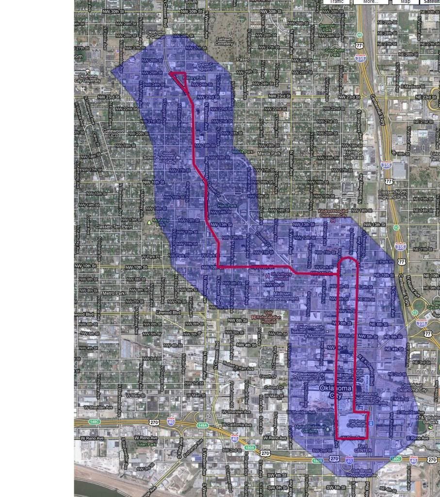
This is a tad over at 6.25 miles...
I think a couplet like this would be interesting... Robinson northbound/Broadway southbound to encourage walking in the "core" and at the same time minimize crossing the street to a line (I think UP mentioned that)... but I feel strongly that Broadway and Robinson would have to "match" in scale... narrow both to two auto lanes with back in angled parking... perhaps Robinson could be "claimed" by A-Alley and have a similar streetscape... it could make use of the interesting loop by the flower market... then double track to Classen and create a "spine" like UP was talking about... at the northern terminus the park in the Asian district could make and nice turnaround station with the iconic Milk bottle in sight... the shaded area is again about a 3-block walk.
Participating Member
Platemaker, what you have drawn on Broadway and Robinson is exactly the couplet design that I was writing about. Tier2City also described what you have drawn correctly. It is an equal distance all the way through the core and creates this "Transit Mall".
Participating Member
I guess I feel that way if they maintain their current appearance as "big" streets... decrease them to a more human scale (upgrade pedestrian infrastructure like you say) and I think we agree.... speaking about north of 4th specifically.
Currently the scale of both streets is better for a couplet from 4th to Sheridan.
Participating Member
From this "Transit Mall" you can extend lines on 4th to Health Sciences, 10th and/or 13th to West Midtown and on to the Asian District / Classen Corridor, due North on Robinson towards Paseo, and/or due south on Robinson to Capitol Hill.
Participating Member
Ok. That brings up a second question. Where are the dual street stops on this couplet? 10th, 8th, 6th, 4th, 2nd, Sheridan? I need to go look at 8th street. I don't remember what it is like (pedestrian/sidewalk wise).
Participating Member
Add to that an extension on NW 6th and onto Linwood (a potentially GREAT street)... and Sheridan to Hudson to Main then west on Main (that opens expansion to both the Fairgrounds and down Exchange to the Stockyards)
Participating Member
I agree on those except change 2nd to Park.
Participating Member
And via either route to the airport. Mike Carrier will tell you that the Convention Center is able to punch way above its weight (size, age) because of its proximity to Bricktown. A link to the airport by "enhanced" streetcar (say Exchange to Stockyards, then the Newcastle rail line, or Fairgrounds and then down hotel row on Meridan) will fully cement our Tier2City status. Hey, that's my handle!
Participating Member
What we need is a REAL master plan... something like...
Participating Member
That's where we are headed. A large master plan. Most of the emphasis and focus right now is on the core system itself because of Project 180. But it will be coming "down the pike."
Participating Member
Let's just cross our fingers that the master plan and what we get out of MAPS 3 compliment each other.
VIP Member
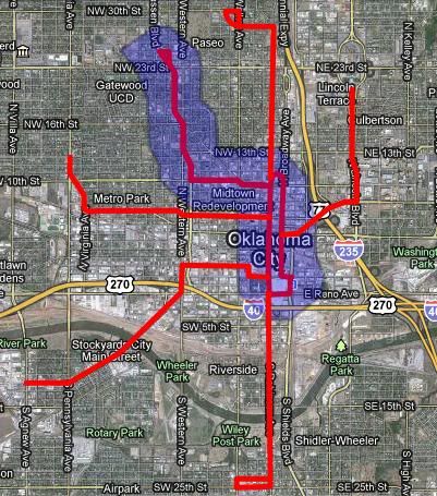
Ok, so let me get this straight. The loop around Robinson and Broadway becomes the transit mall and any streetcar coming into downtown take this loop. Due to the turn at Broadway and Sheridan streetcars will run in this loop in a clockwise direction. If correct, does this mean there is no hub because now instead of one central station we have a central loop? If we still have a hub won't streetcars be on the wrong side of the street to integrate with Sante Fe Station?
I think it would be better for the loop to run counter-clockwise (North on Broadway and south on Robinson). This would have 4 benefits.
1. The street car would be on the correct side of the street for a Bricktown station/hub at Sante Fe.
2. The train would be going with the flow of traffic at the U-turn on the north end of the loop
3. A streetcar entering the loop would make a right turn entering the central loop thus allowing it to not have to cross 2 lanes of traffic
4. The little jog in the track necessary at EKGaylord and Broadway would encourage development of the long vacant "chamber of commerce" site becasue a stop could be added right in front of it..
The problem is still the tight turn on to Broadway whick leads me to my next observation. All of the street cars I have looked at (Portland, Toronto, Europe) have the street cars in the center of the roard, or as close to as they can. They never travel in the right lane. I assume this is so they don't get stuck behind cars waiting to make right turns and avoids possible accidents with parked cars (cars pulling out of parking spaces or opening doors). If this is correct then a streetcar should be able to make the turn from the left lane of Sheridan to Broadway pretty easy.
BTW Platemaker - thanks for making adjustment by St Anthonys. With news today that this area is not living up to expectation in the TIF district this will help that area pay back the money and add a major employer/service center to the network.
There are currently 1 users browsing this thread. (0 members and 1 guests)
 Posting Permissions

 Reply With Quote
Bookmarks