Main area of hail right now below. Also showing a strong inflow area near 134th and Rockwell, so damaging wind threat is going up.

Main area of hail right now below. Also showing a strong inflow area near 134th and Rockwell, so damaging wind threat is going up.

mPING hail report of 1.75" in Mustang.
Radar estimated hail size now up to 2.29".

I'd agree with the hail size. Jeeze! Seems to be passed, now. Three of my neighbors just got new roofs from previous hail damage. I don't even want to look at our roof and the old van parked outside.
Updated warning text...
BULLETIN - IMMEDIATE BROADCAST REQUESTED
SEVERE THUNDERSTORM WARNING
NATIONAL WEATHER SERVICE NORMAN OK
349 AM CDT SUN MAR 31 2013
THE NATIONAL WEATHER SERVICE IN NORMAN HAS ISSUED A
* SEVERE THUNDERSTORM WARNING FOR...
CLEVELAND COUNTY IN CENTRAL OKLAHOMA...
MCCLAIN COUNTY IN CENTRAL OKLAHOMA...
* UNTIL 430 AM CDT
* AT 346 AM CDT...NATIONAL WEATHER SERVICE METEOROLOGISTS DETECTED A
SEVERE THUNDERSTORM LOCATED 4 MILES EAST OF NEWCASTLE...AND MOVING
SOUTHEAST AT 40 MPH.
HAZARDS IN THE WARNING INCLUDE...
LARGE DAMAGING HAIL UP TO GOLF BALL SIZE...
DAMAGING WINDS IN EXCESS OF 60 MPH...
* LOCATIONS IMPACTED INCLUDE...
NORMAN...MOORE...PURCELL...NEWCASTLE...NOBLE...SLA UGHTERVILLE...
BLANCHARD...LEXINGTON...GOLDSBY...WAYNE...WASHINGT ON...COLE...
DIBBLE...ETOWAH...ROSEDALE...CRINER...STANLEY DRAPER LAKE...LAKE
THUNDERBIRD AND PAYNE.
Looks like the hail core is riding along and to the west of US 77, so most of Central and Eastern Norman might avoid the hail.
Here is the current overlay of the PING reports from NSSL with hail sizes reported as it came through Norman.

Got quarter-sized hail in Central Norman, but had friends in the SW part of Norman (from campus westward) with up to 2.00" hail and damage. One had lawn chairs destroyed, and the other reported that every car in her lot was dented. Both Westheimer and the Mesonet gusted up to 59MPH as well.
The first photo is hail on the porch of my shed 8 hours after the storm passed, with an air temp of 60 degrees. I was out there at 4:30AM and the amounts were not to be believed. This is east of 24thNW and Lindsey.
The next photo is of my "baby," who had a rough night.

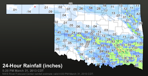
I was tempted to have bet that the storms would bypass Stillwater as radar was looking like the system was going to neatly split to the north and south of Stillwater, which is how it turned out to be. Much of Tulsa area didn't get a drop, either. Most of the SE quarter of Oklahoma did pretty good with handsome rain amounts.


Return of severe weather next week?
SPC 4-8 Day Outlook
...CNTRL/SRN PLAINS - D8...
MODELS ARE IN GOOD AGREEMENT SHOWING AN UPPER TROUGH DEVELOPING OVER
THE WRN CONUS AFTER ABOUT D7 WITH RISING HEIGHTS OVER THE ERN
STATES. THIS WILL ALLOW FOR SUBSTANTIAL MOISTURE RETURN ACROSS THE
PLAINS...WITH MODERATE SWLY FLOW ALOFT. WHILE TIMING OF EMBEDDED
SHORTWAVES IS UNCERTAIN...IT APPEARS THE THREAT FOR DRYLINE
SUPERCELLS WILL BE ON THE INCREASE LATE IN THE PERIOD FROM KS INTO
OK AND TX. BOTH THE GFS AND ECMWF DEPICT MID 60S F BOUNDARY LAYER
DEWPOINTS AS FAR N AS NRN OK BY 00Z ON THE 9TH.


Active pattern remains.
Looks like a soaker on Tuesday night and Wednesday afternoon.
Warms and dries back up until another shot at rain Sunday.
Then large system exits rockies around Tuesday next week.
Everything is going to be nice and green in a few weeks.


Green is the season between April 29th and May 2nd.
There are currently 1 users browsing this thread. (0 members and 1 guests)
Bookmarks