Widgets Magazine
Page 5 of 5 FirstFirst 12345
Results 101 to 103 of 103

Thread: The genius that is Wayne Coyne

  1. Default Re: The genius that is Wayne Coyne

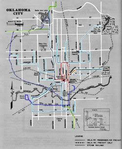
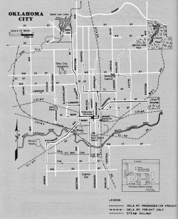
    Generally confirming what Jim said about the end of the trolleys, what remained of the city trolley lines ended by April 1947, and all interurbans but the Norman line ended in November 1946, the latter interurban's last run to Norman being September 27, 1947. Allison & Chandler's fine book, When Oklahoma Took the Trolleys (Interurbans 1980) shows the trolley and interurban lines as follows (click on an image for a larger view -- I've color coded the lines in the 2nd picture):

    Original Map and then as color coded


    About the path of NW 19th Street, I'm not able to find any maps which show the portion west of Grand Boulevard circa 1940-1950 ... that area was not then part of Oklahoma City proper, so it won't show up in the Sanborn maps, nor does the area appear in the "Manley's Map" first published in the mid-1930s and updated through the latter 1940s. I have no other resources which would track the location of NW 19th west of Grand Boulevard during the time period involved in this discussion. If I run across any, I make another comment.

  2. #102

    Default Re: The genius that is Wayne Coyne

    Quote Originally Posted by Free Won't View Post
    While I agree with this question, I have called animal control years ago a couple of times to report dead animals on the road---the lady on the other end didn't seem to care. She made it clear that their priority was live animals.

    I hope it's changed since.
    Maybe they don't have much of a priority with live animals, either. Last year I adopted a homeless cat that was said to have lived in the streets of the Asian District for at least a year.

  3. #103

    Default Re: The genius that is Wayne Coyne

    Quote Originally Posted by Doug Loudenback View Post
    Allison & Chandler's fine book, When Oklahoma Took the Trolleys (Interurbans 1980) shows the trolley and interurban lines as follows (click on an image for a larger view -- I've color coded the lines in the 2nd picture)
    I see one error on the map, Doug: it shows the Linwood line ending on NW 20. It was definitely NW 19; I lived on NW 21 in 1939-40 just east of Independence. Map makers often introduce deliberate errors into their maps, to trap copyright violators, so this may be such a case. It's easy to verify my statement, though, since NW 19 still has a median in that area while NW 20 does not.

Thread Information

Users Browsing this Thread

There are currently 1 users browsing this thread. (0 members and 1 guests)

Tags for this Thread

Bookmarks

Posting Permissions

  • You may not post new threads
  • You may not post replies
  • You may not post attachments
  • You may not edit your posts
  •  
Single Sign On provided by vBSSO