SPC has outlined upcoming Monday with 15% probability of severe weather for C and W OK. This is all the way out on day 7 - which is a rare occurrence.


SPC has outlined upcoming Monday with 15% probability of severe weather for C and W OK. This is all the way out on day 7 - which is a rare occurrence.


OH just looked at Tuesday yeah there be a risk area central/eastern Oklahoma for Tuesday also. Classic set up THAT WILL CHANGE


GFS indicating the back half of April could be busy with some spicy severe weather days ranging from central Oklahoma and west.


The GOOFUS model.

Does it look like Moore will get any measurable rain before 7PM today?


A small cluster of severe storms is swinging up from the SW along I-44. Looks like they will hold together to at least give OKC some winds and rain.


Well the Storm prediction center did not put in a risk area yet for Tuesday which now looks like it may be more Arkansas however they went enhanced risk six days out for Central Western Oklahoma. This is a CLASSIC SETUP. Location will change some but make sure your storm shelter is clean this weekend which it should be this time of year anyway
https://twitter.com/weathertrackus/s...39tqrhuSw&s=19


Oh I'm sure he will get going soon. I'm sure they all will. Technically it's not enhanced this far out but 30% chance which is high. However the hype train as I call it will be in full effect cause dare I say it Thursday is looking really good also. Two chances next week it's possible. I will say though this set up might warrant the hype train people need to be aware but just keep checking back IT'S GOING TO CHANGE.


https://www.weather.gov/oun/ Unlike the past couple systems the moisture will be there this time around.


30% Risk outline on the day 6 outlook is extremely rare. Not to say it guarantees a big day (by definition it only says confidence in Slight or Enhanced Risk weather occurring). But history says it is not used lightly.
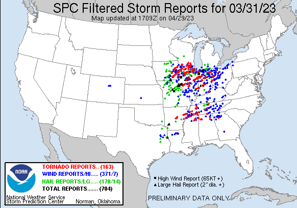
For some perspective, the last time a Day 6 had 30% probabilities, it went on to be the only High Risk day last year and resulted in a large-scale tornado outbreak.


The 30% region was expanded west and east by SPC this morning. There is uncertainty on where exactly dryline will be on Monday. Hopefully. It doesn't setup in west central Oklahoma as that tends to maximize the severe potential for the metro area.
https://twitter.com/NWSNorman/status...52099828633639


I don’t know how much uncertainty there is at this point. The models have been very consistent with the placement of the dry line over the past 6 runs. I think they’re getting more comfortable with the orientation and placement of the dry line. Granted, we’re still 5 days out. However, things have been awfully consistent so far, and that graphic you posted has okc square in the middle of this. I’m getting vibes of a big big day coming up.
That being said, the models are hinting at a giant line of storms, and the shear, while present, doesn’t seem super aligned with what I would expect would be indicative of PDS tornado development. Also, the cap isn’t super strong. We have seen morning storms fire on days like this and completely wipe the energy from the atmosphere for the afternoon storms. There’s lots to evaluate still, but at a minimum, I’m feeling like this could be a really bad day for hail.


Let's get through Monday before we start talking about Thursday. Kind of what the SPC is doing. In the wake of this lead system, the shortwave trough digging into
the Pacific Northwest may carve out a broad, positive-tilt trough in
the West by mid-week. Consensus of guidance suggests that rich
low-level moisture over the southern Great Plains will not be
scoured by the lead wave. This may yield daily bouts of severe
thunderstorms across parts of the central and southern Great Plains
late in the period and beyond. Predictability for individual day
highlights is too low to warrant 15 percent probabilities yet.
I think common sense dictates we all tap the brakes on everything other than acknowledging the SPC forecast for Monday. April and May are bad enough in Oklahoma without unintentional efforts to summon the next wave of destructive weather.
Yeah, there's clearly enough signals that Monday will be a weather-aware day but we don't need to go Full Morgan until we get closer


There are currently 1 users browsing this thread. (0 members and 1 guests)
Bookmarks