Widgets Magazine
Page 4 of 5 FirstFirst 12345 LastLast
Results 76 to 100 of 116

Thread: Severe Weather Outlook - May 12 & 13th

  1. Default Re: Severe Weather Outlook - May 12 & 13th

    Large hail core with hail over 1" will pass along the central and eastern sides of Edmond in a few. Looks like it should stay east of Kelley. Additional back building development is possible. Storms have transitions to the hail/wind threat, tornado threat should be very low for the rest of the night for the metro.

    New tornado warning for the Gracemont area.

  2. Default Re: Severe Weather Outlook - May 12 & 13th

    Another area of interest will be 4 SSE of Mountain View or 6 NW of Alden in SW Oklahoma.

  3. Default Re: Severe Weather Outlook - May 12 & 13th

    Anadarko - Gracemont area..... Tornado - you should be in your shelters.. be safe!
    " You've Been Thunder Struck ! "

  4. Default Re: Severe Weather Outlook - May 12 & 13th

    Circulation moving into Anadarko right now, but is weakening. Law enforcement reporting wind damage to trees in the area with winds around 60 mph.

  5. Default Re: Severe Weather Outlook - May 12 & 13th

    Line of storms now building back to NW Expressway and Mustang Road. OKC proper should expect storms with 1" up to 2" hail possible over the next hour.

  6. Default Re: Severe Weather Outlook - May 12 & 13th


    Urgent - immediate broadcast requested
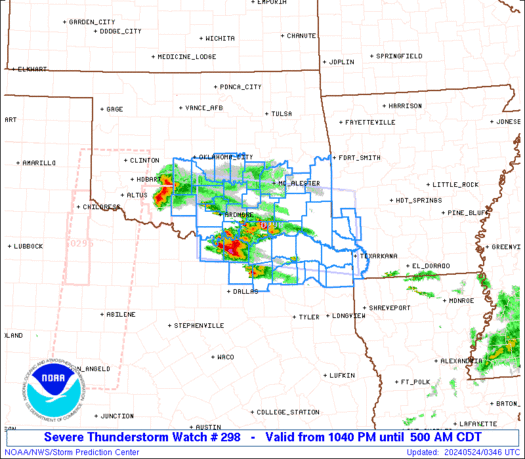
    severe thunderstorm watch number 298
    nws storm prediction center norman ok
    940 pm cdt wed may 13 2009

    the nws storm prediction center has issued a severe thunderstorm watch for portions of

    northwest arkansas
    southern and eastern oklahoma
    a small part of northwest texas

    effective this wednesday night and thursday morning from 940 pm until 400 am cdt.

    Hail to 2 inches in diameter...thunderstorm wind gusts to 70 mph...and dangerous lightning are possible in these areas.

    The severe thunderstorm watch area is approximately along and 105 statute miles east and west of a line from 30 miles northwest of harrison arkansas to 35 miles west southwest of ardmore oklahoma.
    For a complete depiction of the watch see the associated watch outline update (wous64 kwns wou8).

    Remember...a severe thunderstorm watch means conditions are favorable for severe thunderstorms in and close to the watch area. Persons in these areas should be on the lookout for threatening weather conditions and listen for later statements and possible warnings. Severe thunderstorms can and occasionally do produce tornadoes.

    Other watch information...continue...ww 293...ww 295...ww 296...ww 297...

    Discussion...a broken band of severe storms...with some embedded supercells...continues to develop swd/sewd along the cold front across ok. Despite the loss of daytime heating...strong instability and pronounced convergence/low-level frontogenesis will help maintain existing storms and support new development for the next several hours. Large hail can be expected with the strongest storms...while the damaging wind threat should increase some as a result of storm mergers/interactions and subsequent cold pool and small bow echo formation.

  7. Default Re: Severe Weather Outlook - May 12 & 13th

    Bulletin - immediate broadcast requested
    severe thunderstorm warning
    national weather service norman ok
    943 pm cdt wed may 13 2009

    the national weather service in norman has issued a

    * severe thunderstorm warning for...
    Cleveland county in central oklahoma...
    Lincoln county in central oklahoma...
    Southeastern logan county in central oklahoma...
    Northwestern mcclain county in central oklahoma...
    Oklahoma county in central oklahoma...
    Northern pottawatomie county in central oklahoma...
    Northwestern seminole county in east central oklahoma...

    * until 1045 pm cdt

    * at 942 pm cdt...national weather service doppler radar indicated
    severe thunderstorms along a line extending from 3 miles northeast
    of kendrick to northern oklahoma city...moving south at 20 mph.

    Hazards in the warning include...
    Hail up to the size of golf balls...
    Wind gusts to 60 mph...

    * locations in the warning include del city...edmond...midwest
    city...moore...norman...oklahoma city and shawnee.

  8. Default Re: Severe Weather Outlook - May 12 & 13th

    If you experience any hail at your location, please consider reporting it:

    HaSDEx Project

  9. #84

    Default Re: Severe Weather Outlook - May 12 & 13th

    to my insurance agent..

  10. #85

    Default Re: Severe Weather Outlook - May 12 & 13th

    Venture, any possibility this could build into Canadian County? It's lightning here, and the power is flickering off and on. The wind is picking up too.

  11. Default Re: Severe Weather Outlook - May 12 & 13th

    Yeah power is flickering here in Norman and it is a ways away. Lot of wind out there right now. It probably will keep back building.

  12. Default Re: Severe Weather Outlook - May 12 & 13th

    Two metro area hail reports so far. 1.5" in Edmond and 0.88" in Nichols Hills.

    Elevated rotation right now is at I-35 and I-44.

  13. Default Re: Severe Weather Outlook - May 12 & 13th

    Bulletin - eas activation requested
    tornado warning
    national weather service norman ok
    1007 pm cdt wed may 13 2009

    the national weather service in norman has issued a

    * tornado warning for...
    Central cleveland county in central oklahoma...
    Northern mcclain county in central oklahoma...
    Southern oklahoma county in central oklahoma...

    * until 1045 pm cdt

    * at 1006 pm cdt...national weather service doppler radar indicated a
    severe thunderstorm capable of producing a tornado over central
    oklahoma city...near downtown oklahoma city...moving south at 20
    mph.

  14. Default Re: Severe Weather Outlook - May 12 & 13th

    Some unqualified reports of power flashes in East Moore/SE OKC.

  15. Default Re: Severe Weather Outlook - May 12 & 13th

    Tornado warning
    national weather service norman ok
    1045 pm cdt wed may 13 2009

    the national weather service in norman has issued a

    * tornado warning for...
    Eastern cleveland county in central oklahoma...
    Southern oklahoma county in central oklahoma...
    Western pottawatomie county in central oklahoma...

    * until 1145 pm cdt

    * at 1045 pm cdt...national weather service doppler radar indicated a
    severe thunderstorm capable of producing a tornado over southern
    oklahoma city...near stanley draper lake...moving southeast at 15
    mph.

    * locations in the warning include eastern norman...lake
    thunderbird...pink...southeastern oklahoma city...stanley draper
    lake...stella and tinker air force base.

    This includes interstate 40 between mile markers 157 and 164.

  16. Default Re: Severe Weather Outlook - May 12 & 13th

    Okay that was way too close! I wasn't done bowling, but finished 3 games. Extremely heavy rain and I guess pea to dime size hail. The circulation they was reporting was just down the street from my apt, and over Luke's house. It went over mom's house as well. On the drive home (just got home now), heavy rain, poor visual, streets flooded, 44th flooded, the apt parking is flooded. Lightnings insane. Fuzzy the cat going berserk, I'm trying to type this. Amazing storm! I'm frickin soaked!

  17. #92

    Default Re: Severe Weather Outlook - May 12 & 13th

    Quote Originally Posted by jstanthrnme View Post
    well.. looks to me like OKC proper's excitement for the day was really early this morning.
    I take that back. Ohhh, do i take that back. . .

  18. Default Re: Severe Weather Outlook - May 12 & 13th

    Looks like it's pretty much settled in the North part of the metro.. maybe Lake Thunderbird area might be affected... Franklin area Indian Hills Road.... but I think we're done. Goodnight. I hope!
    " You've Been Thunder Struck ! "

  19. Default Re: Severe Weather Outlook - May 12 & 13th

    Yeah, everywhere behind these storms should be quiet for the rest of the night. You can go to bed now, Karrie. You're safe.

  20. #95

    Default Re: Severe Weather Outlook - May 12 & 13th

    For Venture:

    Thanks for the updates, again!

  21. Default Re: Severe Weather Outlook - May 12 & 13th

    I was thinkin, if the inflow to suddenly stop feeding the storms and they collaspe, we could see the top to surface jet stream and heat burst again, but that'd be so rare to happen 2 nights in a row. Would be amazing!

  22. Default Re: Severe Weather Outlook - May 12 & 13th

    lol ... Spock

    Thanks everyone for the updates.
    " You've Been Thunder Struck ! "

  23. #98

    Default Re: Severe Weather Outlook - May 12 & 13th

    I spent all evening cleaning up from Tuedays nights storm, finally got done around dark, came in to join in on the thread....and the flickering power knocked me offline......grrrrrr. Glad nothing touched down on the southside. I still hate the EAS warnings..dbl grrrrrr. Can you believe through all those stroms last night it didnt rain hard enough at our house to get the ground wet. So I'll have to water today. lol It was an awesone lightning show though.

  24. Default Re: Severe Weather Outlook - May 12 & 13th

    Apparently Norman is in a time warp - LOL - but here is the PNS for today so far. Will also be keeping an update of information here: http://www.anvilcrawlers.com/index.p...le=May_13_2009

    PUBLIC INFORMATION STATEMENT
    NATIONAL WEATHER SERVICE NORMAN OK
    920 AM CDT THU MAY 15 2009

    ...DAMAGE SURVEYS TODAY...

    METEOROLOGISTS ARE CONDUCTING DAMAGE SURVEYS TODAY TO INVESTIGATE
    TORNADOES AND WIND DAMAGE THAT OCCURRED ON WEDNESDAY MAY 13TH.

    SO FAR WE HAVE CONFIRMED A TORNADO THAT BEGAN ABOUT 9 MILES SOUTH OF
    NARDIN AT 654PM AND ENDED AT 705PM. WE ALSO BELIEVE THERE WAS A
    BRIEF LANDSPOUT TORNADO 1 MILE EAST OF FAY IN DEWEY COUNTY

    WE WILL BE SURVEYING DAMAGE FROM GRACEMONT TO ANADARKO TO CADDO
    COUNTY TO TRY TO DETERMINE THE CAUSE OF THE SUBSTANTIAL DAMAGE
    THERE. PRELIMINARY ASSESSMENT OF DAMAGE REPORTS AND RADAR DATA
    INDICATE MUCH OF THE DAMAGE MAY HAVE BEEN REAR FLANK DOWNDRAFT
    WINDS...AND GIVEN THE COMPLEX STORM EVOLUTION THAT TOOK PLACE IT MAY
    BE DIFFICULT TO DETERMINE DEFINITIVELY WHAT HAPPENED.

    WE WILL LIKELY BE LOOKING AT DAMAGE AT LAKE STANLEY DRAPER WHERE
    DAMAGE CONCIDES WITH AN IMPRESSIVE RADAR SIGNATURE THAT PROMPTED A
    TORNADO WARNING FOR THE OKC METRO AREA.

    WHILE A GROUND SURVEY IS NOT PLANNED FOR KAY AND NOBLE COUNTIES...WE
    WILL BE COORDINATING CLOSELY WITH EMERGENCY MANAGEMENT TO GATHER
    DETAILS ON DAMAGE TO HELP MAKE A DETERMINATION OF TORNADO INTENSITY.

    WE WILL RELEASE INFORMATION AS SOON AS WE HAVE IT.

  25. Default Re: Severe Weather Outlook - May 12 & 13th

    A little off topic but my Father in law is visiting next week and he is a weather buff.. are there any tours or anything that we can see related to weather at the Norman Weather Service facility or is it closed to the public?

    Anyone know?
    " You've Been Thunder Struck ! "

Thread Information

Users Browsing this Thread

There are currently 1 users browsing this thread. (0 members and 1 guests)

Similar Threads

  1. Severe Weather - April 26th - Potential Tornado Outbreak
    By venture in forum Current Events & Open Topic
    Replies: 78
    Last Post: 04-27-2009, 02:18 AM
  2. Severe Weather - Apr 25 (Sat)
    By venture in forum Current Events & Open Topic
    Replies: 72
    Last Post: 04-26-2009, 02:00 AM
  3. Upcoming Weather Outlook
    By venture in forum Current Events & Open Topic
    Replies: 41
    Last Post: 04-25-2009, 01:33 PM
  4. Severe Weather - March 30, 2009
    By venture in forum Current Events & Open Topic
    Replies: 17
    Last Post: 03-31-2009, 07:29 PM

Bookmarks

Posting Permissions

  • You may not post new threads
  • You may not post replies
  • You may not post attachments
  • You may not edit your posts
  •  
Single Sign On provided by vBSSO