I'm a little surprised the watch area is as far north and west as it is, given the air temps. It's in the high 50s in my part of S OKC and I have a hard time seeing anything too big going up nearby.
I'm a little surprised the watch area is as far north and west as it is, given the air temps. It's in the high 50s in my part of S OKC and I have a hard time seeing anything too big going up nearby.


This info from this morning still looks to be holding true as we head into the evening. We really need to have the storms developing around Lawton to creep further north for OKC to have a shot at any meaningful rain tonight. Current radar trends show that being a tall order.
Latest NAM


Man, who in OKC upset mother nature? We are a desert, and are desperate for rain.
Axis of heavy rain is currentlt setting up just east of the OKC metro potentially backbuilding into OKC/Moore/Norman. There will be some 3"+ totals with this line of storms that should last for the next 4-6 hours.
HRRR model for 10 pm

We've got about a quarter inch of cold rain here the last half-hour or so


I know that as we move further into April, these boundaries will lose a little steam and will stop setting up so far south and we’ll get some rain out of these systems. However, this is frustrating with how little rain okc and north has been getting.


So is OKC basically now free and clear? Or will there be more coming in later? Seems like it's all south of us.


COLD FRONT FOR THE WIN. It's way further south than anyone thought. Still might get some rain in the metro tonight but over all the front pushed a lot further east.


Storms developing directly over OKC proper right now! *applause*


Storm coming into SW OKC is severe.
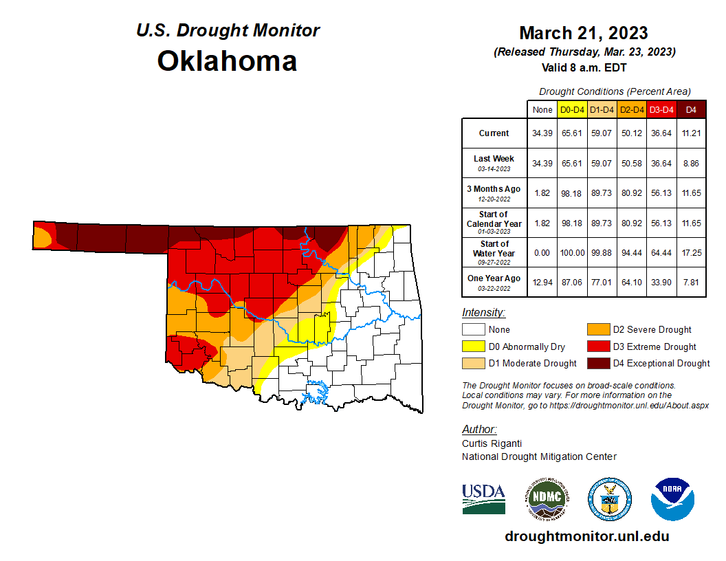
It depends on where you live in Oklahoma and even Oklahoma County. It's interesting how this year the weather systems have been setting themselves up complete with training rain so that that most of eastern and southern Oklahoma is now cleared of drought. It's also, interesting how extremes have gone from exceptional drought in northern Osage County to no drought at all in much of neighboring Tulsa County.
With the current rain train producing system, Stillwater has only gotten .1" at best, while an hour away to the south Shawnee has had 2.5" of rain, so far. I-44 is a major cut off area. The situation won't change until the cold fronts delay passing through northern and central Oklahoma so soon in the day as before noon. The only downside to that is that a delay to later in the afternoon gives tornadoes and big
hail a more favorable time to develop.


2023 in an image.


Let's do this all again next Thursday March 30th shall we. SPC already has 15% area for much of Oklahoma.
That is pretty typical this time of year. The classic dryline setups usually don't happen until later in April when there is better moisture return across the Plains.
What is unusual about this year is the sharp divide along I-44, there is usually a gradient but not as pronounced and typically is further west. Likely a lingering side effect of the extreme drought across western OK into Kansas.
2/3 of the state is running at or above normal rainfall over the last 180 days, which is typically our driest period


I’m so sick of cold weather.


Computer Models starting to agree a bit more for Thursday. This doesn't look like a cold front situation however CAP might come into play and limit storms. Stay tuned


The Thursday-Friday storm is looking more meh today with most of the rainfall in far eastern OK (big surprise). The models are indicating a period of unsettled weather starting late the following week into Easter weekend that looks more classic severe weather setup with much warmer temps (into the 80's!) and higher dewpoints, and gets more of western OK into the action for once.


SPC still has the 15% probabilities marked across the S Plains for Thursday. However, this looks like a low chance, high threat situation. Would not be surprised for tomorrow's 3 day to just be Marginal category.
There are currently 2 users browsing this thread. (0 members and 2 guests)
Bookmarks