

Storms are developing now across S KS and NC OK. We could see two different waves/clusters of storms. Either way, most of the state will likely see storms tonight, and severe properties are likely.
NC and NW OK has a small shot at a tornado or two with initial storm development. Eventually these will come together and form an MCS that pushes S and E.
W and C OK has a good shot at seeing damaging winds. SPC is indicating a 30% chance of high wind event for the area. While the storms mentioned above will be mostly confined to N half of OK, an additional cluster is forming out in the panhandle area that will race eastward as we head into night time hours. This will likely pick up speed and become a very large bow-echo scenario that sweeps across the state from NW to SE.
Storm timing into OKC is very different with all the models (due to the volatile storm cluster speed) I will venture to say around midnight is a decent bet. But this could be earlier if the storms line up earlier and accelerate. Just be prepared for a high wind event.


Did we hit 90s today?


Looks like we will finally hit 90 for the first time on Thursday. If not Thursday, then for sure on Friday before another stormy pattern sets in for the weekend through the beginning of next week. After that, we might have our first real dry period in quite a while.


Severe Thunderstorm Watch is out for all of C and W OK. Again, severe wind gusts is the primary threat. Some small hail is possible, too.
Current storms are not lined up fully just yet, so speed is not maximized at this time. I would put storms in OKC closer to 1am.


Well...that hail woke me up.
^Where was the hail centered. I didn't hear any far NW but plenty of thunder and hard rain.


How long did news 9 stay with Wall to Wall coverage I fell asleep about 12:30. I thought it was crazy they were wall to wall more not that severe thunderstorms but that is another topic.


Hottest day of the year so far coming for Friday. OKC should touch mid 90s. Slight chance of a few storms bubbling up in SW OK, may make a run toward C OK by sunset. Storms will likely die out after sunset, so chances are low for OKC.
Saturday night looks like Severe weather is likely for W half of OK. Storms will fire out W and push E, likely in a large squall line impacting C OK overnight. Damaging wind will be main threat, as well as some hail.
Storms re-fire on Sunday, but uncertainty is high on exact location of development. At this time it looks like it may be just E of OKC.


Flood watch is out for most of C and N/NE OK. This is for Saturday night through Sunday night. Same forecast as above, but it is looking like storm development on Sunday may occur directly along I-44 corridor, thus the extended flood watch window.
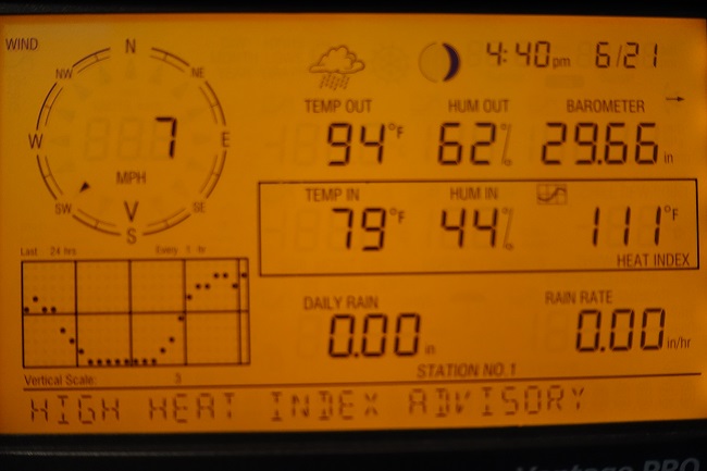
Hottest day of year came with high heat index advisory at my weather station. Hopefully, thunderstorms won't get very severe later this weekend:


So Channel 5 has their tornado index at a 6 for Metro South and East for Sunday 6-23. I think Channel 5 has just gone off the deep end here lately. Maybe it's just me but they seem to go to the most extreme thing that could happen quicker than others.
Unfortunately Damon Lane has trended albeit slightly in the more hysterical direction. That "tornado index" is just a crapwad variation in the idiotic "Torcon" number the blessed Weather Channel puts out. The general trend of *all* weather casts these days seems to tread toward the hysterical and inflammatory - "55 million at risk for storms!" is one of the particularly useless nuggets even NWS has started tossing in. Grrrr.
Severe thunderstorm watch 431 is in effect until 1000 am cdt
for the following locations
Oklahoma counties included are
alfalfa beckham blaine
canadian craig creek
custer dewey ellis
garfield grant harper
kay kingfisher lincoln
logan major noble
nowata oklahoma osage
pawnee payne rogers
roger mills tulsa washington
washi ta woods woodward


Channel 5 in General I think has passed 4 as the new "hype" channel. It was a 6 for the 5 news. They took it down to a 4 for the 10 pm news but then were saying things like the front might clear us out. So why not wait until putting a risk out until morning. Channel 4 and 9 mentioned nothing about tornadoes on their weather cast. As of Sunday Morning everything has pushed into SE Oklahoma. Just how much time do these people think we need to prepare for storms?


Does it look like the weather will be settling down next week?


Slight chance for some thunderstorms bubbling up Tuesday afternoon and evening. Otherwise quiet, with temperatures creeping toward normal summer highs in the low 90s.


Finally to the annual 4 month boring weather stretch.


Let's bottle up today and keep it awhile! Chamber of Commerce day if there ever was one.
There are currently 1 users browsing this thread. (0 members and 1 guests)
Bookmarks