


Oh. So what does on-hold mean then? It literally just sits there with no talk or anything about it?

 Participating Member


Oh. So what does on-hold mean then? It literally just sits there with no talk or anything about it?
Owner / Administrator

I guess what I'm saying is I don't see a need for designating anything as on hold.
Participating Member
I'm almost thinking this thread might deserve to be marked sticky. Very valuable resource. I've been helping out where I can too.
Participating Member
Thanks a million!Originally Posted by baralheia

Owner / Administrator
Just did a massive update to this...
For those helping with the map, this is a good checklist to make sure everything is covered:
Urban Project Summary - OKCTalk
Participating Member
Very nice!
Here is a link to the maps on Gmaps for this page: https://www.google.com/maps/d/u/0/ed...0.k6VwEG_cmKNg
Participating Member
Is it possible to shift these to a different category or map once completed? It seems a shame to lose the coordinates and links on the site for projects once done.
Owner / Administrator
It would be nice to have a different color / category for complete, under construction and planned.
Participating Member
We have Orange for u/c, blue for proposed(would proposed be planned?), so if someone wants to make one for complete feel free! How long should the completed projects stay on the map?
Participating Member
I had actually added a "Completed Projects" category (colored light gray) some time ago, but it appears to have been removed.Completed projects could stay on the map pretty much indefinitely, as you can turn the display of entire categories on and off with just one checkbox, but we might want to standardize with adding a completion date either to the title or body of the info popup. If we do want completed projects to drop off, I'd say the time limit should be something like 6 months to a year or so...
Also, how are we defining the cut between "Proposed" and "Under Construction"? Does a project flip to U/C when a permit is issued, or once dirt starts moving? My thought would be once actual construction begins, but what do you guys say?
Participating Member
You know, that has been an issue I have had. Since I'm no longer in Oklahoma, I can't be there to see if the projects have turned dirt or not so with the smaller projects I've just been making them show as U/C after a permit has been issued, but with the more high profile ones, I've been waiting for actual construction reports.
I agree with you I'd wait until they actually start construction.
Participating Member
I went ahead and added the "Completed" category back.
Owner / Administrator
This is awesome!
I did something similar a while back but it was too much work for just me to keep current.
Thanks so much guys and keep up the great work!
Owner / Administrator
Here is how to add an image to the map for each project, which is easy to do and will greatly enhance the info.:
1. To get the URL for the image (off the Urban Project Summary or from the wiki article; these are all sized at 375 px wide) , just right click on the image itself and chose 'Copy image address' to put it on your clipboard:
2. Then, go to the map and click on the project. A box pops up and at the bottom there is a camera icon; when you click on it you'll see this:
3. Merely paste the link from the picture into the Image URL box.

Participating Member
I'll go through sometime this week and add as much as I can.
Owner / Administrator
You guys need to look into having only approved people make changes.
As it is, anyone can change or delete things posted to the map.
Participating Member
How would I go about doing that? I know there is a function where you can make it editable by anyone or only the person that started the map. Is there a way to select certain people?
That is one thing that has concerned me is a troll going through and doing something stupid like deleting a bunch of stuff for no reason or the like.
Participating Member
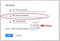
Click the Share button, then under Who has access, click Change.... Select your preference for how people can access your map - Either On - Public on the web or On - Anyone with the link are the options you want. This only changes how users can view your map. To change the Edit preference, change the Access: drop-down to Can view, then click Save. Finally, back on the Sharing Settings screen, under Invite people:, enter the user names or e-mail addresses of the users you would like to specifically grant edit access to.
Owner / Administrator
^
So, PluPan is the owner?
If so, they anyone wanting edit access needs to send him a PM with your email address or Google ID.
Owner / Administrator
This is such a valuable resource and tool I created a page for it and embedded the map:
Development Map - OKCTalk
And for quick reference, it's now a drop-down selection on the Urban Projects menu:
Thanks to all who have and continue to contribute to this project!
Participating Member
I added a bunch of pictures to a lot of the developments.
Participating Member
122nd & Rockwell
There is some dirty movement on the south side of the new Autozone.
Owner / Administrator
Zaxby's
Participating Member
I added the future commuter rail. This will be really cool to see come to fruition.
Participating Member
What kind of timeline are we looking at for the commuter rail line?
There are currently 1 users browsing this thread. (0 members and 1 guests)
 Posting Permissions

 Reply With Quote


Bookmarks