Widgets Magazine
Page 23 of 33 FirstFirst ... 1819202122232425262728 ... LastLast
Results 551 to 575 of 816

Thread: General Weather Discussion - April 2014

  1. #551

    Default Re: General Weather Discussion - April 2014

    Quote Originally Posted by bchris02 View Post
    No need for insults.
    While you're right about that, try to not go overboard on posting the same things over and over. At this point, you come across as panicky and that clogs up the thread for the serious weather information.

    Just listen to anon and venture and you'll be better than with anything Mike Morgan has to say.

  2. #552

    Default Re: General Weather Discussion - April 2014

    Quote Originally Posted by GoOKC1991 View Post
    Reed Timmer: Meteorologist and Extreme Storm Chaser
    5 hours ago
    I would not be surprised if this Saturday, Sunday, and Monday will be the most significant multi-day tornado outbreak in the U.S. since 2011. Saturday and Sunday will be focused from KS/NE south to TX, and a large part of the central/Lower MS River Valley eastward on Monday. Stay tuned, as this could be a very dangerous storm system for most of the southern U.S. east of the Rockies.
    Am I the only one who finds this statement to be somewhat irresponsible, especially coming from a "trained weather professional?"

  3. #553

    Default Re: General Weather Discussion - April 2014

    Quote Originally Posted by adaniel View Post
    Am I the only one who finds this statement to be somewhat irresponsible, especially coming from a "trained weather professional?"
    I agree. Not even Mike Morgan who generally forecasts a worst-case scenario is taking it that far.

  4. #554

    Default Re: General Weather Discussion - April 2014

    Quote Originally Posted by Dessert Fox View Post
    And fire will rain from the skies.
    OKC Boomer?

  5. #555

    Default Re: General Weather Discussion - April 2014

    Quote Originally Posted by Plutonic Panda View Post
    OKC Boomer?
    Naw, new guy. I've been watching the forum as a guest and finally decided to register.

  6. #556

    Default Re: General Weather Discussion - April 2014

    Quote Originally Posted by bchris02 View Post
    I agree. Not even Mike Morgan who generally forecasts a worst-case scenario is taking it that far.
    Reed Timmer is still in reality-show mode. He'll hype a rainbow as the harbinger of death and plague if it gets him on the air.

  7. #557

    Default Re: General Weather Discussion - April 2014

    Quote Originally Posted by bchris02 View Post
    I agree. Not even Mike Morgan who generally forecasts a worst-case scenario is taking it that far.
    The weekend is young. I suspect Morgan is cooking up his own special brew of Terrifying Weather Adjectivestm for just this occasion.

  8. Default Re: General Weather Discussion - April 2014

    Maybe Mike will get a new sparkle tie.

  9. #559

    Default Re: General Weather Discussion - April 2014

    Quote Originally Posted by SoonerDave View Post
    The weekend is young. I suspect Morgan is cooking up his own special brew of Terrifying Weather Adjectivestm for just this occasion.
    Double, double toil and trouble;
    Fire burn, and caldron bubble.

  10. #560

    Default Re: General Weather Discussion - April 2014

    Quote Originally Posted by venture View Post
    Maybe Mike will get a new sparkle tie.
    He is going to reveal his new tie with LED lights.

  11. #561

    Default Re: General Weather Discussion - April 2014

    Quote Originally Posted by SoonerDave View Post
    I suspect Morgan is cooking up his own special brew of Terrifying Weather Adjectivestm
    Gotta love it!

  12. Default Re: General Weather Discussion - April 2014

    Storm with golf balls heading for Chickasha. Will be there in about an hour.


  13. #563

    Default Re: General Weather Discussion - April 2014

    That storm in the back is a trooper.

    Also additional development occurring in NW TX. hopefully we can get some training MCS's going and give us good rain.

  14. #564

    Default Re: General Weather Discussion - April 2014

    Quote Originally Posted by venture View Post
    Storm with golf balls heading for Chickasha. Will be there in about an hour.


    Sigh... Time for the hail preparation ritual.

  15. Default Re: General Weather Discussion - April 2014

    Okay, after a relatively mild severe weather day - which was no where near KWTV's or KFOR's moderate risk - it is time to move on to look at this weekend. Now there are a lot of scary things being put out there. I'm debating how best to present this because we really haven't had the best run to run consistency. One run will show an amazing setup and the next a bustpalooza.

    For the last few days the most reliable and consistent model in this has been the ECMWF. So I'm going to start with that. We are looking at moisture return beginning late Friday. This means that the atmosphere will be limited on just how primed it can get with quality moisture. By late Friday dews in the 50s should be common from the Metro area south to the Red. Mid 60s by Saturday morning and continue through the day. I then get concerned though because it shows daytime highs out in Western OK reaching into the low 90s. That's a pretty significant depression storms will need to overcome. Regardless, Euro has storms breaking out along the dryline by 7PM moving into South Central OK by 1AM. Then it pops up some random heavy rain at 7AM to the NW of the OKC metro area. Cold front doesn't move through until early Monday based on the Euro, but the dryline apparently gets some boosters and blasts to I-35 by 1PM Sunday. It then effectively stalls out and retreats slightly before the front moves it out. So as far as Sunday is concerned, wherever that dryline stalls out is going to be very key.

    I know I'm focusing on the dryline a bit, but let's be honest - if you are west of it this weekend - you are pretty much out of the woods for the most significant severe weather. Looking back at the previous Euro runs. Looking at the 12Z run on the 22nd at 1PM Sunday it had the dryline roughly Bartlesville-Tulsa-Seminole-Thackerville. The 00Z on the 23rd at 1PM Sunday had it running right on I-35. On the 12Z on the 23rd for 1PM Sunday had it running Alva-Watonga-Duncan-Waurika. Then this run it is snapped back east to about 20-30 miles west of I-35. So we had a trend of 3 runs of moving further west and now a snap back to the east. We need to get things to settle down regarding boundary placement.

    When we look at the GFS for the 1PM time frame on Sunday, it is much further east than the Euro. It is almost 60 miles further east than the Euro's current solution. This is a bit further west than the 18Z run earlier on Wednesday. Okay so that's the surface. Let's go upstairs...

    Classic negatively tilted trough comes in for the weekend. You might be like, what the heck is a neg tilted trough. Well here is an image from the GFS for Sunday evening.


    A trough that is leaning back or digging in, however you want to phrase it, is a negatively tilted trough. Both GFS and Euro show this. Euro is a bit further to the west for this time frame (7PM Sunday)...which definitely raises concern significantly for Sunday. To put it simply, you really don't want to be at the tip of the finger pointing at you while having conditions favorable for storms.

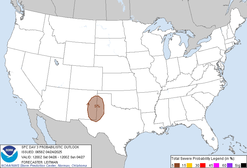
    So I'll stop there before going into anymore detail. We have the possibility for a significant weather evening Saturday and Sunday. There are still a ton of questions for either day, but what big day doesn't have that. As I was typing this the new Day 3 came out for Saturday, so I'll post that next and see how far off I am. LOL

  16. Default Re: General Weather Discussion - April 2014


    DAY 3 CONVECTIVE OUTLOOK
    NWS STORM PREDICTION CENTER NORMAN OK
    0212 AM CDT THU APR 24 2014

    VALID 261200Z - 271200Z

    ...THERE IS A SLGT RISK OF SVR TSTMS ACROSS THE CENTRAL AND SOUTHERN
    PLAINS...

    ...SUMMARY...
    SCATTERED SEVERE THUNDERSTORMS ARE EXPECTED TO DEVELOP ALONG A
    DRYLINE ACROSS PORTIONS OF KANSAS...OKLAHOMA...AND PARTS OF WEST
    TEXAS. VERY LARGE HAIL...AND POSSIBLY TORNADOES...CAN BE EXPECTED.

    ...CENTRAL AND SOUTHERN PLAINS...

    STRONG MID-LEVEL SPEED MAX IS FORECAST TO ROUND THE BASE OF A
    PROGRESSIVE TROUGH ALONG THE SWRN U.S./MEXICAN BORDER EARLY SATURDAY
    BEFORE SHIFTING INTO NM BY 27/00Z. THIS FEATURE WILL THEN EJECT
    INTO THE CNTRL HIGH PLAINS OF WESTERN KS OVERNIGHT...INCREASING TO
    80KT+ AT 500MB. INTENSE 12-HR MID-LEVEL HEIGHT FALLS...APPROACHING
    200M...WILL DEVELOP ACROSS THE HIGH PLAINS CENTERED ON SERN CO.

    AS UPPER TROUGH SHIFTS INTO THE SRN ROCKIES...SFC LOW WILL DEEPEN
    OVER ERN CO AND A WELL-DEFINED LEE TROUGH WILL EXTEND SWD INTO NRN
    MEXICO. INTENSE HEATING IS EXPECTED ALONG THIS TROUGH DURING THE
    DAY AND A DRYLINE SHOULD MIX INTO THE ERN TX PANHANDLE BY 21Z.
    WHILE WARM SECTOR BOUNDARY LAYER MOISTURE IS EXPECTED TO GRADUALLY
    INCREASE ACROSS THE SRN/CNTRL PLAINS OVER THE NEXT FEW DAYS IT
    APPEARS DRYLINE CONVECTION MAY INITIALLY INGEST 50S SFC DEW POINTS
    AS TEMPERATURES RISE THROUGH THE 80S...TO PERHAPS NEAR 90F FARTHER
    SOUTH ACROSS THE EDWARDS PLATEAU. CONVECTIVE TEMPERATURES SHOULD BE
    BREACHED BY 21Z AND SCT SUPERCELLS ARE EXPECTED TO DEVELOP ALONG THE
    BOUNDARY. THIS ACTIVITY WILL INITIALLY BE DRIVEN BY DIABATIC
    HEATING AS LARGE-SCALE FORCING ASSOCIATED WITH APPROACHING SPEED MAX
    WILL LAG THIS CORRIDOR OF INITIATION UNTIL WELL AFTER DARK. DELAYED
    LARGE-SCALE SUPPORT MAY LIMIT THE NUMBER OF STORMS THAT ULTIMATELY
    EVOLVE ALONG THE DRYLINE.

    CONVECTION THAT DEVELOPS DURING THE LATE AFTERNOON WILL DO SO ALONG
    A NARROW CORRIDOR OF 3000 J/KG SBCAPE AND SHOULD MATURE INTO THE
    EARLY EVENING HOURS AS VERTICAL SHEAR INCREASES FROM THE WEST.
    SUPERCELLS WITH VERY LARGE HAIL...GREATER THAN 2 INCHES...ARE
    EXPECTED.
    AS TSTMS SHIFT EAST AND BOUNDARY LAYER COOLS SLIGHTLY
    THERE MAY BE A PROPENSITY FOR CLOUD BASES TO LOWER AND TAKE
    ADVANTAGE OF LOWER 60S SFC DEW POINTS. AS A RESULT...TORNADO THREAT
    SHOULD INCREASE DURING THE EARLY EVENING HOURS BEFORE ACTIVITY
    DECOUPLES FROM THE BOUNDARY LAYER.


    WITH LARGE SCALE FORCING EXPECTED TO EJECT INTO THE PLAINS OVERNIGHT
    THERE MAY BE CONVECTIVE REDEVELOPMENT ALONG THE DRYLINE AS IT BEGINS
    TO SURGE ACROSS SWRN KS/WRN OK/NWRN TX.

    SEVERE PROBABILITIES MAY BE INCREASED ACROSS THIS REGION IF
    MID-LEVEL SPEED MAX/FORCING OVERSPREADS THE DRYLINE AT A MORE
    FAVORABLE TIME DIURNALLY.

    ..DARROW.. 04/24/2014

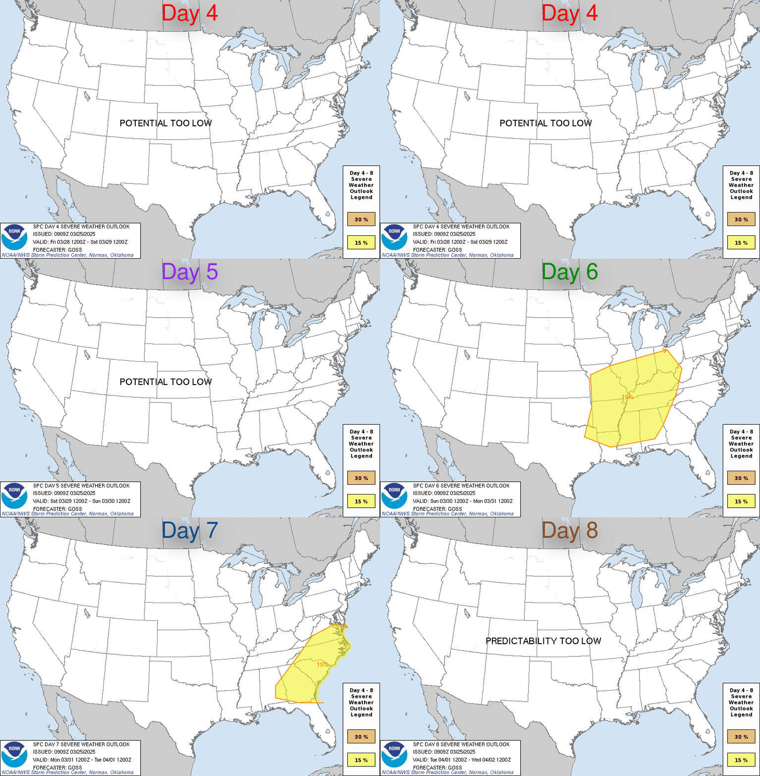
  17. Default Re: General Weather Discussion - April 2014


    DAY 4-8 CONVECTIVE OUTLOOK
    NWS STORM PREDICTION CENTER NORMAN OK
    0338 AM CDT THU APR 24 2014

    VALID 271200Z - 021200Z

    ...DISCUSSION...
    ...SIGNIFICANT MULTI-DAY SEVERE EVENT EXPECTED ACROSS PORTIONS OF
    THE CENTRAL/SOUTHERN PLAINS AND MS VALLEY SUNDAY...AND MS
    VALLEY/CNTRL GULF STATES ON MONDAY...STRONG TORNADOES ARE
    POSSIBLE...

    BOTH THE ECMWF/GFS ARE IN GENERAL AGREEMENT REGARDING THE EVOLUTION
    OF UPPER LOW AS IT PROGRESSES INTO THE PLAINS SUNDAY...THEN INTO THE
    MS VALLEY MONDAY. AFTER INITIAL SPEED MAX EJECTS INTO THE CNTRL
    PLAINS SUNDAY SUBSTANTIAL MID-LEVEL FLOW DEVELOPS WITHIN THE BASE OF
    THE TROUGH OVER TX AND SPREADS ACROSS THE LOWER MS VALLEY INTO THE
    NCNTRL GULF STATES/TN VALLEY. ECMWF IS MORE SUPPRESSED WITH THIS
    STRONGER FLOW THAN THE GFS BUT THE IDEA THAT STRONG FLOW SHOULD
    OVERSPREAD A BUOYANT AIRMASS BOTH DAYS REMAINS.

    MODELS CONTINUE TO SURGE THE DRYLINE ACROSS THE PLAINS EARLY IN THE
    PERIOD WITH BOTH AGREEING THAT SIGNIFICANT BOUNDARY LAYER DRYING
    WILL SPREAD EAST OF I-35 CORRIDOR FAIRLY EARLY SUNDAY. GIVEN THE
    MID-LEVEL JET THAT EJECTS INTO THE CNTRL PLAINS EARLY THIS MAY
    TRANSPIRE AND SEVERE THUNDERSTORMS SHOULD EVOLVE FROM SERN
    NEB...ACROSS ERN KS/OK INTO NERN TX BEFORE SPREADING INTO WRN
    MO/AR/NWRN LA.

    DEEP SFC CYCLONE WILL GRADUALLY SHIFT EAST ACROSS THE CNTRL PLAINS
    AND ARCING FRONTAL POSITION AT 12Z MONDAY SHOULD EXTEND ALONG/NEAR
    THE KS/MO BORDER...SWD INTO SERN TX. SEVERE THUNDERSTORMS SHOULD
    REDEVELOP ACROSS THE WARM SECTOR AS 80KT 500MB FLOW EJECTS ACROSS
    THE LOWER MS VALLEY INTO WRN TN DURING THE DAY. A FEW STRONG
    TORNADOES MAY BE NOTED WITH SUPERCELLS THAT DEVELOP ALONG/AHEAD OF
    DRYLINE/PACIFIC FRONT BOTH SUNDAY AND MONDAY.

    ..DARROW.. 04/24/2014

  18. Default Re: General Weather Discussion - April 2014

    Day 4 change is in line with the faster moving dryline I had spoken about. It seems they are wanting to follow this thinking the models have pushed in the majority of the last few runs. If this surge east takes place than Western and most of Central OK gets hot and dry Sunday with high fire danger.

    I'll throw it out there that there is a possibility the Central third of Oklahoma gets out of this without high end severe weather. However, if we see the dryline explode with convection and long lived supercells make it into the evening/overnight feeding off the LLJ...then ignore that last sentence. Regardless of what the local heads say - nothing is set in stone.

  19. #569

    Default Re: General Weather Discussion - April 2014

    Venture... According to the SPC they now have a slight chance for Saturday and have seemed to focus more on Sunday and Monday to a "severe threat" with some strong tornadoes possible. Do you concur that Sunday may be a worse day? This could possibly be good news for bchris02 as OKC wouldn't really see the "highest chance" of impacts it would be just east of OKC to Tulsa to Little Rock.

  20. #570

    Default Re: General Weather Discussion - April 2014

    Quote Originally Posted by adaniel View Post
    Am I the only one who finds this statement to be somewhat irresponsible, especially coming from a "trained weather professional?"
    Reed Timmer works for ratings, and only ratings. He is a very bright guy, but I'm not sure why anyone would take his opinion over other professionals, especially when the hype machine has been known to be in effect.

    Some of the models have me doubting a large scale outbreak (particularly tornadoes) on Saturday. Moisture return seems to be getting increasingly meager on the models, and yesterday's dewpoints verified much lower than models had it. The drought is doing its magic. It wouldn't totally shock me to see just a few supercells go up. Unfortunately, meager or not, the moisture return is expected to increase right around sunset, so it wouldn't shock me if the tornado threat existed into the night which is obviously no good -- but I'm not sure I'm seeing epic outbreak on Saturday like maybe I once was. Still some nasty analogs being noted by CIPS, but that's assuming the modeled dewpoint values are correct (among other things).

  21. #571

    Default Re: General Weather Discussion - April 2014

    Quote Originally Posted by Soonerman12 View Post
    Venture... According to the SPC they now have a slight chance for Saturday and have seemed to focus more on Sunday and Monday to a "severe threat" with some strong tornadoes possible. Do you concur that Sunday may be a worse day? This could possibly be good news for bchris02 as OKC wouldn't really see the "highest chance" of impacts it would be just east of OKC to Tulsa to Little Rock.
    It's good for everyone in central Oklahoma, not just me. I don't think I'm the only person who doesn't want to see a catastrophic outbreak like last year.

  22. #572

    Default Re: General Weather Discussion - April 2014

    Looks like moisture return Sat is going to be the ultimate key in this whole setup....

  23. #573

    Default Re: General Weather Discussion - April 2014

    bchris02... I understand it would be great but severe weather is going to happen no matter what. A ton of deaths unfortunately happen due to people not caring about warning sirens and not taking mets seriously. When the tornado hit Joplin a few years back there was a lot of people that honestly said they thought it was just another false alarm and went about it like nothing was going to happen. If people have a plan, and take what we are all saying seriously, there is no reason for any deaths. I know your response will probably be well some people don't have adequate shelter for a tornado but the truth is there are multiple places to go if you don't. When I was younger I lived in Bartlesville, OK and we would always go to the parking garage at the hospital if we knew a severe storm was coming. For one, we went there to protect our cars from hail damage, and two, parking garages are solid concrete and have stair wells in them with reinforced steel. I'm not saying by any means get out in drive during a storm but if you watch the weather and there saying there is a storm heading your way you have at least 15-20 minutes to figure something out. Living in tornado alley means there are a lot of people with shelters that would likely let you get in them with them. We have a few days til this makes it here to figure out the best structure to go to and everything. People should honestly watch the weather closely the day of and not just tune in once the clouds get dark.

  24. #574

    Default Re: General Weather Discussion - April 2014

    Quote Originally Posted by SoonerDave View Post
    Looks like moisture return Sat is going to be the ultimate key in this whole setup....
    The drought has sometime impacted the quality of moisture avaiable.
    To some degree it seems like the residual moisture in east Texas seems like it would have an impact? but to what degree I'm not sure......?
    They have seen recent rains.
    Based of the map on the link (Keetch-Byram Drought Index) it looks like SSE winds would bring back better moisture than winds out of the due south? Any thoughts?


    http://twc.tamu.edu/tfs/kbdi_daily/kbdi4km.png

  25. #575

    Default Re: General Weather Discussion - April 2014

    Quote Originally Posted by ou48A View Post
    The drought has sometime impacted the quality of moisture avaiable.
    To some degree it seems like the residual moisture in east Texas seems like it would have an impact? but to what degree I'm not sure......?
    They have seen recent rains.
    Based of the map on the link (Keetch-Byram Drought Index) it looks like SSE winds would bring back better moisture than winds out of the due south? Any thoughts?

    http://twc.tamu.edu/tfs/kbdi_daily/kbdi4km.png
    Winds from the SSE or SE empirically bring back more moisture as they're typically sourced out of the Gulf of Mexico, bringing in buckets of humidity to fuel a storm-favorable environment.

Thread Information

Users Browsing this Thread

There are currently 17 users browsing this thread. (0 members and 17 guests)

Similar Threads

  1. General Weather Discussion - March 2014
    By venture in forum Weather & Geosciences
    Replies: 240
    Last Post: 03-31-2014, 09:23 PM
  2. General Weather Discussion - February 2014
    By venture in forum Weather & Geosciences
    Replies: 426
    Last Post: 02-28-2014, 11:54 PM
  3. General Weather Discussion - January 2014
    By venture in forum Weather & Geosciences
    Replies: 203
    Last Post: 02-02-2014, 09:54 AM
  4. Oklahoma Severe Weather Discussion - April 2012
    By venture in forum Weather & Geosciences
    Replies: 399
    Last Post: 05-01-2012, 10:00 AM
  5. Oklahoma Severe Weather Discussion - April 2011
    By venture in forum Weather & Geosciences
    Replies: 286
    Last Post: 04-30-2011, 12:28 AM

Bookmarks

Posting Permissions

  • You may not post new threads
  • You may not post replies
  • You may not post attachments
  • You may not edit your posts
  •  
Single Sign On provided by vBSSO