

I almost never hope we don't get rain but I'm supposed to be having the fence replaced Monday and if it pours this weekend the back yard will be Lake Robertson.


We Denver folks are starting to get nervous,,,,,,,,2-3 feet??? Maybe as much as 40" if all things fall into place. Eeeesh!


Thank God they've cut it back to 1-2 feet. Wahhhhh!
Can we keep this focused on OKC weather? Isn’t there a Denver forum more appropriate for you to post on?


Then don't read the posts. You can actually do that, you know.


Rain/Storm chances are still changing for OKC. Looks like C OK will stay dry and cool tonight, then the boundary will lift back to the north on Friday, bringing warmer temperatures up from the south and sparking showers and storms. However, models are favoring development just barely north of OKC for the majority of precipitation. This scenario would focus heaviest rainfall into NW and N OK for Friday evening.
Then Saturday night we should see dryline action and what will likely become a large line of thunderstorms sweep across the state from W to E.

Good news. I need some solid outdoor weather for Saturday (cycling)!


Latest short-range models indicate a more favorable development zone for OKC than it did yesterday. This is for tonight after sunset.


The boundary just came back through C OK and is hovering just N of the metro. Should be the focal point of shower and storm development tonight.


Ah the beauty/frustration of rapid refresh forecast models.
Latest data pushing the boundary further north than was anticipated even just a few hours ago. OKC may just miss the heavier rain tonight afterall.
Sidenote: First Plains tornado watch of the year was just issues for the southern TX panhandle.

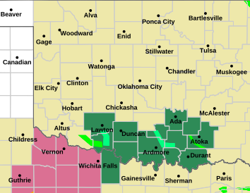
FLOOD WATCH IN EFFECT FROM 9 PM CST THIS EVENING THROUGH SATURDAY MORNING 6 AM.
Showers and thunderstorms are expected to develop along a boundary
through central and northern Oklahoma this evening and overnight.
Locally heavy rainfall is likely with these storms, with flash
flooding possible. Rainfall amounts of 1 to 2 inches are expected
with locally higher amounts of 3 to 4 inches are possible through
Saturday morning.
COUNTIES INCLUDED IN GREEN:


Is it me or is the new NWS radar awful? Used to be my go to but no more. Any recommendations on a good clear radar?
Two animated suggestions from my website, until someone can come up with something more impressive. Both are more suitable for desktop, rather than for phone:
Courtesy of weatherunderground.com, no zoom: https://stillwaterweather.com/okcradar
Zoomable: https://stillwaterweather.com/newwxradar


Yes, the new NWS radar is unfortunately terrible. The RadarScope app is incredible if you don't mind paying a one-time $10 fee to download it. It's the only app I've ever purchased and it's been well worth the money IMO.


Thinking that the SPC will likely pull the trigger on a Moderate Risk from the Texas Panhandle into far western Oklahoma tomorrow for significant hail, and potentially for significant tornadoes as well. The discrete supercells that will form out there should eventually coalesce into a squall line well before reaching OKC late tomorrow night. Just expecting a weakening complex of stores moving through here, likely non-severe but maybe giving us some gusty outflow winds. Unfortunately this system is really looking to underachieve on rain relative to what was forecast earlier this week.
Skies will gradually clear out on Sunday, then next week is shaping up to be beautiful, with low chances for rain and highs in the 60's.
Interesting how the heavy rain has concentrated, so far, away from Oklahoma City, Tulsa, Lawton and Stillwater as of 9 am Saturday.


So far i would say this storm system has been a big bust for the I-44 corridor. All i heard throughout the week was waves of showers and storms and heavy rain and even last night we were in a flash flood watch and that never materialized either. But we all know that the weather, especially in Oklahoma is not easy to predict with so many variables in play. On the flip side we are just now entering our severe / rainy period so there will be many opportunities for rain and of course more chances of busts as well.


Seems like every high res model run is decreasing the chances we see rain more and more. There is some humidity in the air but it’s pretty chilly here right now. My guess is we don’t see anything other than a few sprinkles out of this.


Our Local TV stations so badly need to tone it down. I moved here in 2012 and it was bad however now it seems even worse. Am I wrong on this or have people around here always thought it was bad. Just like today. A certain station was a 6 out of 10 on the tornado risk. Yes the SPC was a moderate risk (not for Oklahoma) but we ended up not even having a watch in the state. One brief Tornado Warning. Why can't we start low and then go up from there? In my opinion there should never be a 5 or 50% chance or higher unless there is at least a Tornado Watch issued. Giving people a heads up is fine but they go way too overboard with it then with nothing happens people will just stop listening.
The over drama does seem worse. Maybe TV weather people are afraid of getting a lot worse heck for under estimating how bad the weather turned out.
I honestly don't even watch the news regarding severe weather unless there is a live event. Anonymous et al are my primary source for severe forecasts. I also follow NWS on Twitter.
There are currently 6 users browsing this thread. (0 members and 6 guests)
Bookmarks