

The Grill in Capitol Hill across street from the Old Langston's has an old map of the Capitol Hill District on the wall if you are interested in looking at it. Or at least it was there about a month ago.

 Participating Member

The Grill in Capitol Hill across street from the Old Langston's has an old map of the Capitol Hill District on the wall if you are interested in looking at it. Or at least it was there about a month ago.
VIP Member
Of course, and thanks!Originally Posted by okckid

VIP Member
I'm presently focusing on the Deep Deuce area to round it out -- several Deep Deuce mini-pages have already been done but I'm wanting to make the area as complete as I can. I'm asking for input from any that care to give it.
I've put together a composite map from segments of the Sanborn Map Company maps from 1922, as modified in 1949 and then, last, in 1955. First, a "greater" Deep Deuce area covering NE 4 to NE 1, Walnut to Byers:
3000 px wide version: http://i8.photobucket.com/albums/a49...eater_3000.jpg
2000 px wide version: http://i8.photobucket.com/albums/a49...eater_2000.jpg
The 800 px wide version, not particularly readable, is below:
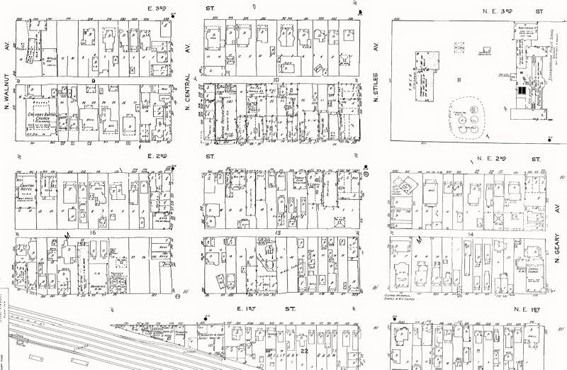
But, what I'm really focusing on is the "central" part of Deep Deuce, NE 3 to NE 1st, Walnut to Geary.
3000 px wide version: http://i8.photobucket.com/albums/a49...ntral_3000.jpg
2000 px wide version: http://i8.photobucket.com/albums/a49...ntral_2000.jpg
The 800 px wide version, not particularly readable, is below:
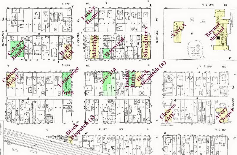
For the "central" version, a marked-up version of the above is shown below -- the colored buildings are those identified with reasonable certainty, green for existing, yellow for destroyed.
3000 px wide version: http://i8.photobucket.com/albums/a49...names_3000.jpg
2000 px wide version: http://i8.photobucket.com/albums/a49...names_2000.jpg
The 800 px wide version, not particularly readable, is below:
The existing buildings which match 314-316 E. 2nd in the Sanborn map are used by the Deep Deuce rental/condo business and also have a swimming pool for occupants' use. A pic I took yesterday is below:
As for the Littlepage and the small apartment building south of it, I'm good for research on those buildings.
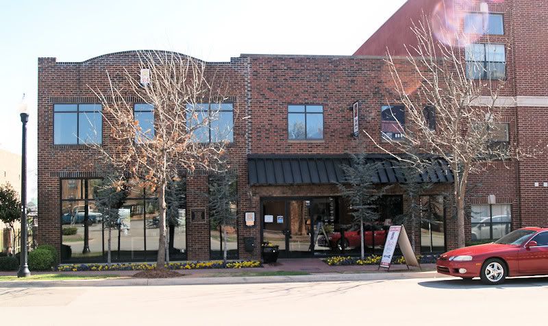
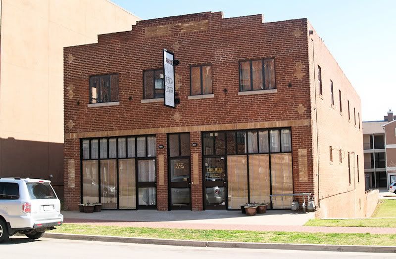
But, for the building shown in the Sanborn map as "Lodge Hall" at 324 E. 2nd, I'm not satisfied that I have 100% accurate data. Probably, this building was the Elks Victory Lodge building which probably later became Ruby's Grill. So says William D. Welge in Oklahoma City Rediscovered. But, some doubt about that exists in my mind, particularly as the location of Ruby's Grill. Today, it is home for the marketers of the nearby The Hill properties. A pic of that building is shown below.
As for the building immediately east of the Lodge, that building is gone. But Dustury's Charles G. Hill identifies the address of the 2nd location of the Black Dispatch as being 324 NE 2 which is the same address shown in the Sanborn maps for a building identified there as "Printing" so that's almost certainly a match.
My Questions:
- Do you know with reasonable certainty the locations and names of buildings which I've not yet identified in the above? If so, which ones?
- A pair of existing buildings (314-316 NE 2) have not been identified for history purposes ... e.g., names, property use. These buildings have been combined today and house the Deep Deuce Rentals and swimming pool but the owners/operators are also in the dark as to these questions. Does anyone know? A photo I took of these buildings yesterday is shown below.
- Can anyone confirm that Chaz Hill's identification of the "Printing" building shown in the Sanborn map is, in fact, the Black Dispatch 2nd location?
Any help will be appreciated.
Participating Member
Two downtown OKC questions please. It appears through the years any photos taken or street maps begin at Main and go North. I had relatives that owned businesses on the South side of Reno, The Victoria Hotel and OK Billiards. Sanborn maps does have the Victoria, but does not show OKB which was located on the same block.
At one time anything west of Walker was considered "out in the country". Is that how Western Ave. got it's name?
I really enjoy all your sites and appreciate your works and effort.
VIP Member
Thanks, papaOU.
You are quite right, in my observations at least ... except that I'd say that Grand (Sheridan) was more of the "picture border line", although some photos do exist on California that I've seen, but Reno almost nothing. Far more photos were taken from Sheridan and streets north than California and Reno, even more so for streets south of Reno. As a guess, I'd suppose the area north of Grand received the focus because it was where the more dynamic economic activity was going on, certainly for building construction. It was also more "respectable." Around Reno/California Broadway/Robinson, I think there were quite a few saloons and "loose" places that didn't get their pictures taken (although I'd love to have some ... that would be lots of fun).
But, there really is an area that didn't get a lot of pics (at least, pics that have survived) that I've seen south of Sheridan.
About how Western got its name, I really don't know but I'd suppose that, given that Broadway to Harvey was pretty much the center of commercial activity very early on that it was natural to identify both Western and Eastern by reason of compass location from ground zero, so to speak. That's just me guessing.
VIP Member
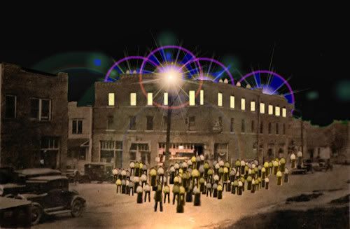
The clickable map for 32 mini-pages in the "greater" Deep Deuce area -- several turned out not to be all-that mini -- are now done and I'd like it if you would have a look and give me your feedback. I may add some other Deep Deuce items later ... I still do not know the name/history of the blond brick building immediately south of the Slaughter Building, for example, so it's not presently in the map. Incidentally, the above is a re-created photo of the Slaughter Building which I did just for fun. The original is included in the Slaughter Building page, of course, but it wasn't very sexy and I thought it needed some attention to try and get the flavor of that building late at night when the bands were playing in Slaughter's Hall.
An index of the 32 items which ARE in the present Deep Deuce list is at this page: Doug Dawgz Blog: Vintage Map Index
All other items presently in the map are there, also, after the Deep Deuce list.
Participating Member
Your maps and accompanying articles are a treat and I for one look forward to viewing them. Two questions. One has been hashed-over before but here goes again. Are there more photos to be found of the "Deuce" than those of Capitol Hill? How did the area on 13th near N. Penn. become home to the Plaza Theater and Plaza Tap Room?
Keep up the good work!
VIP Member
Off the top of my head and without comparing ... far far more Capitol Hill photos exist than do photos of the black area, greater or larger Deep Deuce. If I were to make an off-the-top-of-my head guess, I'd be surprised if the ratio were not greater than 200 to 1 (or even more exaggerated), not kidding. White camera men/women didn't care about the black community which was largely ignored by the whites until probably the 1970s or 1980s and later ... if there are black photographers' photos around I wouldn't know where to find them.
I don't know about the 2nd set of questions (Plaza).
There are currently 1 users browsing this thread. (0 members and 1 guests)
 Posting Permissions

 Reply With Quote
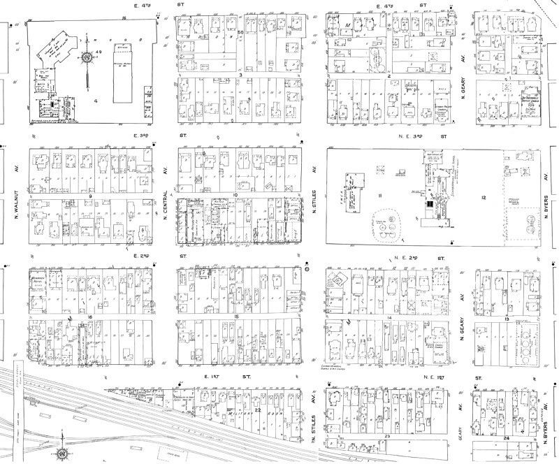
Bookmarks