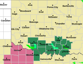
SVR Watch is out. Main threat is large hail and then damaging wind threat with leading edge of clusters.


SVR Watch is out. Main threat is large hail and then damaging wind threat with leading edge of clusters.


Next round of storms likely forms NW of the Metro between 5-8 p.m. today and then moves through the Metro between 7-10 p.m. this evening. With high levels of instability in place, very large hail and significant wind gusts are possible.
Tomorrow and Thursday will be hot and sunny. Starting as early as overnight Thursday, we transition back to a NW flow pattern through at least the end of the weekend, resulting in a return of nightly MCS potential.


None-zero tornado threat this evening from SW to C OK. SPC has it pegged @ 2% currently.
So am I missing something? SPC shows most of OK in a "slight" risk area, but an area from roughly OKC to McAlester (diagonally) is in an *enhanced* risk? No Moderate region? Something odd going on?


Yes it can be confusing, but the criteria for the wind threat meets Enhanced, even though they increased tornado for C OK from 2 to 5%. That still does not meet Enhanced. Just look at the colors for clarification.
Should see supercells develop west of OKC and move ESE and form into a cluster, that is when the wind threat enhances to the E.


Still favor a 7-10 p.m. timing for the Metro. Focus area might be a bit to the south of what was expected this morning. Any tornado potential will likely be related to subtle mesoscale forcing, similar to what happened in SW Oklahoma on April 30th and May 23rd.
Severe Thunderstorm Watch coming for the entire Metro within the next hour.
https://kfor.com/news/local/nws-norm...tornado-count/
100 tornados and counting


Watch is out for all of C OK.
Tornadoes
Probability of 2 or more tornadoes
Low (20%)
Probability of 1 or more strong (EF2-EF5) tornadoes
Low (5%)
Wind
Probability of 10 or more severe wind events
High (70%)
Probability of 1 or more wind events > 65 knots
Mod (60%)
Hail
Probability of 10 or more severe hail events
High (70%)
Probability of 1 or more hailstones > 2 inches
Mod (60%)
Combined Severe Hail/Wind
Probability of 6 or more combined severe hail/wind events
High (>95%)


My read of the situation right now is that the two small cells currently over Yukon and Downtown OKC are struggling to overcome whatever’s left of the cap. Appears to be another attempt at initiation out west from Thomas down to Weatherford. Not sure if this will actually get going before sunset, but would expect that robust convection will eventually fire in that general area and head towards the Metro.
Severe Thunderstorm Watch in Purple Effective: Tue, 6/4 4:55pm
Expires: Wed, 6/5 12:00am Severity: Severe Certainty: Possible


Flash flood threat going to be high from this cell movement.

https://www.wpc.ncep.noaa.gov/heatrisk/
Is this new?


Outside chance of an MCS swinging through the next two nights but low probability.
Otherwise we will make a run at 100F Saturday. But won’t quite make it. Basically find your favorite pool.
Chance of storms in W OK Tuesday then the HEAT DOME returns. Look for temps close to 100 F by next weekend.


This morning I was able to mow because my grass was completely dry. Is there any way to tell from the forecast which mornings my grass won’t be covered in dew? Guess it might have something to do with the dew point?
Oklahoma in the center of the donut hole


Ugh. We had an amazing summer last year. Think we’re going to pay for it this year. I mean, early June and we’re going to be approaching triple digits?!
There are currently 8 users browsing this thread. (0 members and 8 guests)
Bookmarks