

Val and Amy Castor hydroplaned and flipped their truck. Luckily, they are ok.

 Participating Member


Val and Amy Castor hydroplaned and flipped their truck. Luckily, they are ok.
The OKC storm sure dissipated quickly to nothing on its way out to the neighboring county. Stillwater is staying safe between the storms and will stay that way if the strong storms to the north, which haven't dissipated, don't drift too far to the south or new development forms. So far, it's only rained .04" from being on the fringes.
Participating Member
Yeah OKC definitely dodged a bullet this evening.
Participating Member
SE OKC went from tornado nearby to 3 minutes of rain. Draper keeps getting missed by rain. Just kinda frustrating. Meanwhile, Tulsa is about to get pummeled. Draper will lose water quickly over the summer, so it needs the fill up now.
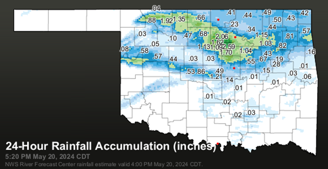
Storms that were just to the north of Stillwater maintained intensity and took on a more ESE drift. There might have been new development. So, Stillwater has been pounded by heavy rain since around 1:30 am with rain now getting over 1.75". Compare that to the NWS forecast that overnight rainfall between a tenth and quarter of an inch possible. Fortunately, no hail or very high wind with the storm. The storm isn't going to stray far enough from east to avoid hitting Tulsa.
Meanwhile, amazing how all the severe thunderstorms in Kansas have just about wound down.
The live video of the hydroplaning and turning is startling.Originally Posted by jn1780

They fill Draper with water from lakes in Eastern Oklahoma. Hugo & Sardis I think.
Participating Member
Yep. Atoka Reservoir, McGee Creek Reservoir, and Sardis Reservoir... Draper is all about holding pumped water, not local collection.
Participating Member
Didn't know that. Thank you for the info!
Participating Member
Oh, there are big long discussions about this on a couple of threads here.
OKC is building a new 100 mile 72inch pipeline to add compacity and be backup to the existing line which itself be upgraded to a 72inch line eventually. We talk about it a lot ever time there is a drought in western Oklahoma. There is talk about why we rely so much on Lake Canton and why don't we pump some of that water back to the Lake Hefner water treatment plant.
Plus there was that whole legal drama over water rights with the tribes.
Participating Member
Not seeing great weather chances in the models for the next two weeks. Seeing a lot of solid dry line setups but not much storm initiation. This is the time of year where I really like to see those MCS’s come through and dump the rain. Hoping this isn’t going to be an early hot dry summer.
Participating Member
The amazing thing about yesterday is there wasn't a week worth of hype. There was only a slight risk. I'm not even sure the Metro had a risk yesterday by the SPC.
Participating Member
They updated the metro to marginal in the afternoon update...
Participating Member
Caught a glimpse of the tornado with the help of the lightning. This was taken at about 9:45pm near Reno and Cemetery while the tornado was near Cimarron and 10th.
Gold Member
That's just Oklahoma.
Participating Member
Didn't a storm take a hard right when it really shouldn't have, and wasn't projected to?
Participating Member
When I first looked at the radar around 4:15, it looked like the northern edge of the metro would get some of the action from the more isolated southern storm, possibly further into the metro if it stayed on a more easterly track, but it felt like it just kept staying east and even southeast at times.
Sunday night turned into a dramatic night of storms as I wondered if I was going to stay on the fringes of the storms with .04" of rain to finding myself not too far from the bullseye of the storms with 3 downpours. When it was over had 2.60" of rain. Far north side of Stillwater had more with just over 3". Northeast of there in Glencoe, a Tempest station has just over 4". Further to the northeast of there, another Tempest station had 4.59" for the most I found. The Oklahoma mesonet rain map below shows gauges will never be widespread enough to catch the specific heaviest rain amounts in the state, though the darkest green spot on the map does correspond to where the 4+" amounts were.
About 4 more weeks to go before the stress of the spring storm season starts transitioning to the more settled summer months.
As previously mentioned, Val and Amy Castor of Stillwater, who are long time storm chasers for KWTV-9 of OKC, hydroplaned on I-40 in the OKC area and crashed. Fortunately, they were not hurt much. The video as it happened is here:
https://www.news9.com/story/664b69f2...-sunday-night-
Storm chances return early morning Wednesday and Thursday as storm complexes move in from the NW. A Slight risk of severe weather mainly high winds and hail early Wednesday. Lower chances Friday and Saturday.
 Participating Member
80 tornados so far in Oklahoma this year. I'm in disbelief that tornados have decreased from prior decades.
Participating Member
Feels like they have decreased in number, but increased in size and an increasing number of nocturnal twisters?
Participating Member
This year has been one of the most active Oklahoma has had since record keeping began in 1950. Only 7 other years had more tornadoes by the end of May, but even that could change by the time the month is over.
2019: 127
1999: 116
2011: 97
2015: 95
2010: 94
1960: 89
1957: 89
2024: 80
Participating Member
Well, it had been pretty quiet the past few years. This year has been active. Just a reminder that we still live in tornado alley. The question is will be back to quiet next year?
We are in a transition period from El Nino to La Nina. Those subtle timing differences can make a big difference.
Participating Member
The wind is going to be pretty wild over the next couple of weeks. I know it will help cool us down but I’m ready for a reprieve.
Participating Member
Getting a lot of tornado watch alerts on my phone here in NE OK. Always a little unnerving when they announce them long before the storm even forms. Plus it is apparently 94 degrees out there right now - hotter than expected...
There are currently 9 users browsing this thread. (0 members and 9 guests)
 Posting Permissions

 Reply With Quote

Bookmarks