Widgets Magazine
Page 1 of 11 123456 ... LastLast
Results 1 to 25 of 264

Thread: General Weather Discussion - January and February 2017

  1. #1

    Default General Weather Discussion - January and February 2017

    Rain is likely Monday morning as a quick band of showers and storms will ride up from the SW.

    Weather turns cold on Tuesday. Highs will struggle to make freezing from Wednesday on into to the weekend.

    Winter precipitation has been wildly inconsistent with the models. Perhaps a chance Friday.

  2. #2

    Default Re: General Weather Discussion - January and February 2017

    So I just saw on the news that okc metro is going to miss out on any snow.

    Any chance for a storm in the coming weeks?

  3. #3

    Default Re: General Weather Discussion - January and February 2017

    I don't think anyone has any idea what's going to happen. Ch 9 is saying the OKC area is likely to get at least a dusting of snow now, and S. OKC could see even more than the northside.

    I think I'm going to roll some dice. Call it the RNG forecast (Random Number Generator).

  4. #4

    Default Re: General Weather Discussion - January and February 2017

    As of this morning. Models are coming in with general amounts between 0-3". With many indications that there will be a very narrow band of the heavier side of things (3"). Both NAM and GFS currently placing that likely band somewhere from Amarillo to about Lawton. Since this system has very little moisture to work with, amounts will be difficult to squeeze out.

    Again, not everyone will see measurable snow. We are talking potentially a swath of about 20-40 miles wide of anything ground-covering, if at all. Storm track is everything.

  5. #5

    Default Re: General Weather Discussion - January and February 2017


  6. #6

    Default Re: General Weather Discussion - January and February 2017

    All I know of Aaron Tuttle is that issue with Red Dirt Report (or whoever) and both parties claiming they were gonna sue one another.
    That aside, is his reputation as a meteorologist solid? That page you sent contained enough information and was put to where I could understand it fully.

  7. Default Re: General Weather Discussion - January and February 2017

    Quote Originally Posted by TU 'cane View Post
    All I know of Aaron Tuttle is that issue with Red Dirt Report (or whoever)
    The Lost Ogle

  8. #8

    Default Re: General Weather Discussion - January and February 2017

    ^^ Ok, I knew it was one of those. Thanks.

  9. #9

    Default Re: General Weather Discussion - January and February 2017

    Afternoon models coming in with about the same as this morning. So we are finally getting agreement. Maybe a trend to shift the heavier band further north towards I-40 corridor instead of south of. Will keep track of this.

    GFS latching onto heaviest snow along I-40 on Friday morning.

  10. #10

    Default Re: General Weather Discussion - January and February 2017

    Models trending towards additional moisture this morning. Thus, snow totals could be higher if it holds. Also the trend to move the heavier band further north over I-40 has continued.

    Winter Weather Advisory for basically central W and C OK for tonight.

    As of this morning here are the model forecast amounts:
    GFS: I-40 corridor heaviest band 2-5" (highest amounts out towards Elk City, then tapering off as you head east)
    NAM: I-40 corridor heaviest band 1-3"
    GEM: I-40 corridor heaviest band 1-2"
    WRF: S of I-40 corridor heaviest band 1-2" (Lawton to Norman area)


    Like I mentioned earlier, this will be a swath of a heavier snowband that may not exceed 20 miles N to S, so every deviation in track will significantly adjust the totals in your area. The radar tonight will tell the real story.

  11. #11

    Default Re: General Weather Discussion - January and February 2017

    I know many people that follow him like a religion.

    Weather Channel shows snow to start in City area around 9:00 this evening through 5:00 tomorrow morning.

  12. #12

    Default Re: General Weather Discussion - January and February 2017

    Quote Originally Posted by Anonymous. View Post
    Models trending towards additional moisture this morning. Thus, snow totals could be higher if it holds. Also the trend to move the heavier band further north over I-40 has continued.

    Winter Weather Advisory for basically central W and C OK for tonight.

    As of this morning here are the model forecast amounts:
    GFS: I-40 corridor heaviest band 2-5" (highest amounts out towards Elk City, then tapering off as you head east)
    NAM: I-40 corridor heaviest band 1-3"
    GEM: I-40 corridor heaviest band 1-2"
    WRF: S of I-40 corridor heaviest band 1-2" (Lawton to Norman area)


    Like I mentioned earlier, this will be a swath of a heavier snowband that may not exceed 20 miles N to S, so every deviation in track will significantly adjust the totals in your area. The radar tonight will tell the real story.
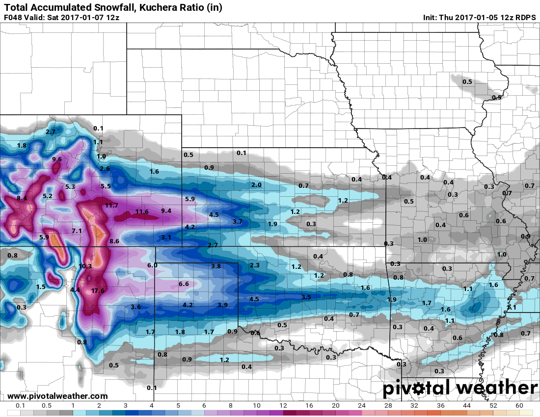
    Canadian model:

  13. #13

    Default Re: General Weather Discussion - January and February 2017

    Quote Originally Posted by Bunty View Post
    Canadian model:
    What do Canadians know about snow?!? ;-)

  14. #14

    Default Re: General Weather Discussion - January and February 2017

    High Resolution models are coming in this afternoon with suggestions of a very narrow strip of heavy snow somewhere south of Woodward and trailing off to the SE towards OKC. 5"+ amounts. Sort of like what we have seen today near Dodge City, KS. A narrow strip of heavy snow just parked over the same area.

    We could see a narrow corridor of counties upgraded to Winter Storm Warnings if a solid heavy snowband develops over a concentrated area.

  15. #15

    Default Re: General Weather Discussion - January and February 2017

    Quote Originally Posted by Of Sound Mind View Post
    What do Canadians know about snow?!? ;-)
    Or modeling...

  16. #16

    Default Re: General Weather Discussion - January and February 2017

    David Payne Ch 9 predicting 1-2 inch in OKC south side getting more than northside. I have seen reports from dusting to 5 inches from other sites.

  17. #17

    Default Re: General Weather Discussion - January and February 2017

    Newest HRRR is near bread & milk levels for OKC.


  18. #18

    Default Re: General Weather Discussion - January and February 2017

    That looks like it's rolling down I-40 taking aim for OKC

  19. #19

    Default Re: General Weather Discussion - January and February 2017

    Quote Originally Posted by Anonymous. View Post
    Newest HRRR is near bread & milk levels for OKC.

    Yep. 6-8" stripe across northern Cleveland County. Would be pretty shocked if that happens, but these bands have been known to do some crazy things.


  20. #20

    Default Re: General Weather Discussion - January and February 2017

    Damn wish that heavier band was a little further north so my place on the NW side got that much but oh well.

  21. #21

    Default Re: General Weather Discussion - January and February 2017

    Quote Originally Posted by bradh View Post
    Damn wish that heavier band was a little further north so my place on the NW side got that much but oh well.
    I think the whole city will be digging out come morning. Looks like a Doozie of a storm headed right for Ok City.

  22. #22

    Default Re: General Weather Discussion - January and February 2017

    I-40 is going to be a the hotspot.


  23. #23

    Default Re: General Weather Discussion - January and February 2017

    Watching the band develop now near Amarillo. It may take aim just south of I-40. But models are saying it will lift north and combine with northern development.

  24. #24

    Default Re: General Weather Discussion - January and February 2017

    Snowing out NW OKC near Piedmont. Streets already covered lightly.

  25. #25

    Default Re: General Weather Discussion - January and February 2017

    I-40 corridor becoming mostly saturated. Heaviest snows will begin reaching ground in next few hours. Still looking at the heaviest band being I-40 with 2-4", isolated heavier amounts in sustained banding.

Thread Information

Users Browsing this Thread

There are currently 14 users browsing this thread. (0 members and 14 guests)

Similar Threads

  1. General Weather Discussion - January/February 2015
    By venture in forum Weather & Geosciences
    Replies: 525
    Last Post: 03-01-2015, 03:38 PM
  2. General Weather Discussion - February 2014
    By venture in forum Weather & Geosciences
    Replies: 426
    Last Post: 02-28-2014, 11:54 PM
  3. General Weather Discussion - January 2014
    By venture in forum Weather & Geosciences
    Replies: 203
    Last Post: 02-02-2014, 09:54 AM
  4. Oklahoma Weather Discussion - January/February 2012
    By venture in forum Weather & Geosciences
    Replies: 262
    Last Post: 02-29-2012, 08:04 AM
  5. February '10 Weather Discussion
    By venture in forum Current Events & Open Topic
    Replies: 145
    Last Post: 02-26-2010, 09:20 PM

Bookmarks

Posting Permissions

  • You may not post new threads
  • You may not post replies
  • You may not post attachments
  • You may not edit your posts
  •  
Single Sign On provided by vBSSO