Widgets Magazine
Page 6 of 7 FirstFirst ... 234567 LastLast
Results 126 to 150 of 155

Thread: General Weather Discussion - July 2014

  1. #126

    Default Re: General Weather Discussion - July 2014

    Happy Birthday.

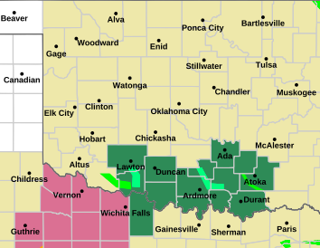
    The situation for the low has it moving somewhat to the north and east, so that Stillwater, Ponca City and Tulsa are now included in the revised Flash Flood Watch until 7am Thursday:


    ...flash flood watch in effect...
    .widespread rain and embedded thunderstorms will move across northern and central oklahoma today. By this evening...the heaviest rainfall is expected in central and eastern oklahoma. The heavy rainfall may result in flash flooding.
    ...flash flood watch in effect from 7 am cdt this morning through thursday morning...
    The national weather service in norman has expanded the
    * flash flood watch to include portions of central oklahoma...
    East central oklahoma and northern oklahoma...including the following areas...in central oklahoma...lincoln...payne and pottawatomie. In east central oklahoma...hughes...pontotoc and seminole. In northern oklahoma...kay and noble.
    * from 7 am cdt this morning through thursday morning
    * rainfall amounts of 2 to 4 inches with locally higher amounts
    * several inches of rain may cause areal flooding...elevated creeks and river

  2. #127

    Default Re: General Weather Discussion - July 2014

    Quote Originally Posted by Bunty View Post
    Happy Birthday.

    The situation for the low has it moving somewhat to the north and east, so that Stillwater, Ponca City and Tulsa are now included in the revised Flash Flood Watch until 7am Thursday:


    ...flash flood watch in effect...
    .widespread rain and embedded thunderstorms will move across northern and central oklahoma today. By this evening...the heaviest rainfall is expected in central and eastern oklahoma. The heavy rainfall may result in flash flooding.
    ...flash flood watch in effect from 7 am cdt this morning through thursday morning...
    The national weather service in norman has expanded the
    * flash flood watch to include portions of central oklahoma...
    East central oklahoma and northern oklahoma...including the following areas...in central oklahoma...lincoln...payne and pottawatomie. In east central oklahoma...hughes...pontotoc and seminole. In northern oklahoma...kay and noble.
    * from 7 am cdt this morning through thursday morning
    * rainfall amounts of 2 to 4 inches with locally higher amounts
    * several inches of rain may cause areal flooding...elevated creeks and river
    Please state your source for this info you have of the Low moving more easterly than south? Anon said the low was moving south word...

  3. #128

    Default Re: General Weather Discussion - July 2014

    Rain looks to be breaking up west and southwest of OKC. Dry slots happen in the summer months too, I guess.

  4. #129

    Default Re: General Weather Discussion - July 2014

    If you want to see how the low is moving, check the Dodge City, KS radar.

    You can clearly see a jog to the east over the last hour or so. However, this does not mean W and C OK are done.

  5. #130

    Default Re: General Weather Discussion - July 2014

    Quote Originally Posted by Anonymous. View Post
    If you want to see how the low is moving, check the Dodge City, KS radar.

    You can clearly see a jog to the east over the last hour or so. However, this does not mean W and C OK are done.
    Yeah, I'm looking at the WunderMap radar and it looks to me like it's clearing out..precip wise. It may stay cloudy but the only way it's gonna be a solid wall of water is if new storms bubble up and another shield of rain drops down. Doubt that's gonna happen. I've experienced this rodeo before.

  6. #131

    Default Re: General Weather Discussion - July 2014

    Quote Originally Posted by Bobby821 View Post
    Please state your source for this info you have of the Low moving more easterly than south? Anon said the low was moving south word...
    I have no source other than my memory of the flash flood watch when first issued yesterday did not include the counties to the north and east as it does today.

  7. #132

    Default Re: General Weather Discussion - July 2014

    so much for 5" in OKC, right?

  8. #133

    Default Re: General Weather Discussion - July 2014

    Exactly.

  9. #134

    Default Re: General Weather Discussion - July 2014

    FWIW, the NWS is expecting some clearing to take from OKC southwestward and then for storms to redevelop due to increasing instability. We shall see!


  10. #135

    Default Re: General Weather Discussion - July 2014

    Yep, I was just about to say that this dry-period wasn't unexpected.

    From the 6:30 am Forecast Discussion (Aviation):
    "WIDESPREAD RAIN AND EMBEDDED THUNDERSTORMS WILL MOVE ACROSS
    THE AREA THIS MORNING INTO THE AFTERNOON. VFR/MVFR CONDITIONS
    ARE EXPECTED WITH OCCASIONAL IFR CONDITIONS WITHIN HEAVIER SHOWERS
    AND STORMS. A FEW SHORT RANGE MODELS BRING SOME DRYING INTO
    WESTERN OKLAHOMA LATE THIS MORNING/EARLY AFTERNOON WITH REDEVELOP
    LATER THIS AFTERNOON/EVENING. LATER THIS EVENING/OVERNIGHT...MAINLY
    OKC/OUN SHOULD BE IMPACTED WITH RAIN AND A FEW STORMS."

  11. #136

    Default Re: General Weather Discussion - July 2014

    NW OK, Buffalo to Woodward are first in the state to go over 2 inches so far.

    NW TX into SW OK has some clearing taking palce, temps are mid to upper 70s there.

  12. #137

    Default Re: General Weather Discussion - July 2014

    Here in NW OKC we got a nice steady rain all day so far but it was no where near the rainmageddon I was expecting. I guess we'll see what happens later tonight.

  13. #138

    Default Re: General Weather Discussion - July 2014

    good info as usual, these threads never disappoint

  14. #139

    Default Re: General Weather Discussion - July 2014

    Rain and embedded thunderstorm really filling in now. Looks like this will happen directly over C OK heading into tonight.

  15. #140

    Default Re: General Weather Discussion - July 2014

    Stillwater is in one of the driest holes in the state getting .45", so far. But, on the other hand, it looks like Oklahoma City better get ready to NOT get bypassed by some downpours for the next hour, or so, including a possible flash flood warning, according to Mike Morgan.


  16. Default Re: General Weather Discussion - July 2014

    Canton Lake has picked up an inch so far today...only 12 feet more and it will be full!

  17. #142

    Default Re: General Weather Discussion - July 2014

    Quote Originally Posted by Urbanized View Post
    Canton Lake has picked up an inch so far today...only 12 feet more and it will be full!
    Actually the lake level went from 1603.00 yesterday to 1603.41 now. That's a pretty good jump for one day, especially during the time of the year when the level normally drops.

  18. #143

    Default Re: General Weather Discussion - July 2014

    Almost 5 inches NE sides of metro and 2-4 inches across the rest.

    Solid rain for July.

  19. #144

    Default Re: General Weather Discussion - July 2014

    Quote Originally Posted by Anonymous. View Post
    Almost 5 inches NE sides of metro and 2-4 inches across the rest.

    Solid rain for July.
    Absolutely, and it was mentioned on the news tonight that Arcadia lake has been going up about 2 inches per hour and could go up by a foot total.

  20. #145

    Default Re: General Weather Discussion - July 2014

    Quote Originally Posted by pahdz View Post
    so much for 5" in OKC, right?
    Some parts of the metro did receive that much.

  21. #146

    Default Re: General Weather Discussion - July 2014

    GFS nailed this system like it was building a house. Never count out wrap-around convection. If this was winter, that spurt in C OK would have dumped 6+ inches of snow.

  22. #147
    Join Date
    Jun 2008
    Posts
    2,690

    Default Re: General Weather Discussion - July 2014

    Always my go to place for meaningful local weather events.

  23. #148

    Default Re: General Weather Discussion - July 2014

    Looking ahead, now.

    Looks like an amazing weekend, mid 80s.

    Next week the heat builds back, but only to lower 90s across most of OK.

    Next shot at rain/cooler temps comines in late next week heading into next weekend. The following week appears unsettled on long-term GFS.

  24. #149

    Default Re: General Weather Discussion - July 2014

    Per the Oklahoma Mesonet ticker...

    Wow, how did I miss this? Apparently Burneyville down near the Red River recorded a 106MPH gust last night and recorded 3" of rain in an hour (with 2" of that occurring in 30 minutes).


  25. #150

    Default Re: General Weather Discussion - July 2014

    Downburst?

Thread Information

Users Browsing this Thread

There are currently 1 users browsing this thread. (0 members and 1 guests)

Similar Threads

  1. General Weather Discussion - June 2014
    By venture in forum Weather & Geosciences
    Replies: 363
    Last Post: 07-06-2014, 02:21 PM
  2. General Weather Discussion - May 2014
    By venture in forum Weather & Geosciences
    Replies: 429
    Last Post: 05-30-2014, 09:39 AM
  3. General Weather Discussion - April 2014
    By venture in forum Weather & Geosciences
    Replies: 815
    Last Post: 05-03-2014, 09:37 AM
  4. General Weather Discussion - March 2014
    By venture in forum Weather & Geosciences
    Replies: 240
    Last Post: 03-31-2014, 09:23 PM
  5. General Weather Discussion - January 2014
    By venture in forum Weather & Geosciences
    Replies: 203
    Last Post: 02-02-2014, 09:54 AM

Bookmarks

Posting Permissions

  • You may not post new threads
  • You may not post replies
  • You may not post attachments
  • You may not edit your posts
  •  
Single Sign On provided by vBSSO