Widgets Magazine
Page 4 of 4 FirstFirst 1234
Results 76 to 96 of 96

Thread: Tropical Weather Discussion 2011

  1. #76

    Default Re: Tropical Weather Discussion 2011

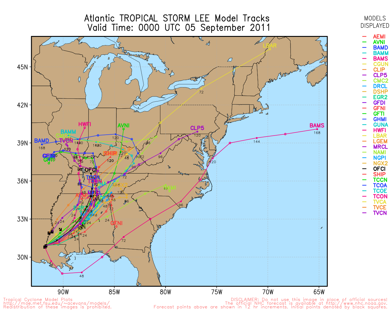
    Thanks for that venture. I think the front will take the system NE but it's interesting to see several models showing a westward or northward movement. I believe that is due to the possibility of the front stalling out before it reaches the coast allowing the storm to stay on its current path to north and northwest.

  2. #77

    Default Re: Tropical Weather Discussion 2011

    Quote Originally Posted by venture79 View Post
    Nice little website to use for people that wonder where most the graphics come from: http://spaghettimodels.com/
    Great site,,,,,,,, thanks

  3. #78

    Default Re: Tropical Weather Discussion 2011

    I'll be selfish and root for it to wander nnw into Arkansas, or anywhere that isn't sw Alabama.

  4. #79

    Default Re: Tropical Weather Discussion 2011

    Quote Originally Posted by kevinpate View Post
    I'll be selfish and root for it to wander nnw into Arkansas, or anywhere that isn't sw Alabama.
    If it interacts with a stalled front it could bring a lot of beneficial rain to our region being such a large system with a significant amount of Gulf moisture. Though most of the rain would be over Arkansas and possibly eastern OK. It will be interesting to watch over the next couple days.

  5. #80

    Default Re: Tropical Weather Discussion 2011

    Yep. I hail from se OK and they are hurting as much as we are it seems, and if the bulk lands in Ark, well, they are hurting too. My elder son and his bride are in sw AL, and they don't need a lot more rain and certainly don't need any significant storms.

    I freely admit it's selfish of me, but yeah, c'mon w/ that nw track!

  6. Default Re: Tropical Weather Discussion 2011

    Good indication of what areas need the most rain. Western half of LA needs is badly, so this will help. However, most points east don't until you get into Central AL and most of GA.


  7. #82

    Default Re: Tropical Weather Discussion 2011

    Sure enough the latest model runs are taking the storm to the NE. No rain for TX/OK......

    I do wonder how this will affect our rain chances with the strong cold front that moves into central OK Saturday night. Does a storm in the Gulf help or hurt our chances, which were pretty slight to begin??

    We may see some clouds from this by morning:


    Latest model run:


    There is still time but we NEED a tropical system to move over TX/OK to help get us out the drought. Normal or even above average rainfall this fall and winter will help but to get back to "normal" we need a lot more rain that only a tropical storm or hurricane can produce...

  8. Default Re: Tropical Weather Discussion 2011

    So here is a run down of what is out there.

    Hurricane Katia is doing her thing, but seems to be weakening some. Storm should stay off shore and continue to curve out to sea. Looks like she will retain hurricane force winds through the transition to an extratropical system by Sunday.

    TD 14 is still struggling to get its act together. It should get to Tropical Storm strength today, and hurricane strength in a few days. The track may be similar to Katia's just further south. It will probably graze the islands, go near/north of PR, and begin to curve out to see before reaching the Bahamas. A couple models do go more south, with one taking it into the Caribbean...however the vast majority recurve out to sea.

    INVEST 96 is forming right now in the Bay of Campeche (Southern Gulf). Models are completely split on what to do with it. Roughly half take is South into Mexico and then out into the Pacific. The other have go Northeast into LA/MS/AL and up into the Great Lakes/Northeast. This is our best shot though for something to spread moisture up to us...either after going into the Pacific the moisture coming back overhead or the storm going NW instead into TX. We will see what happens, but the probability of an Oklahoma impact right now are less than 10%.


  9. Default Re: Tropical Weather Discussion 2011

    Advisories on TS Nate started late this afternoon. Official forecast takes it North and then West into Mexico in the next few days as a hurricane.


    TROPICAL STORM NATE DISCUSSION NUMBER 2
    NWS NATIONAL HURRICANE CENTER MIAMI FL AL152011
    1000 PM CDT WED SEP 07 2011

    SATELLITE IMAGERY...CONVENTIONAL AND MICROWAVE...SHOWS LITTLE CHANGE
    IN EITHER THE POSITION OR THE ORGANIZATION OF NATE DURING THE PAST
    SEVERAL HOURS. THE LOW-LEVEL CENTER REMAINS EXPOSED ABOUT 60 N MI
    NORTHEAST OF THE MAIN CONVECTIVE AREA...AND OVERALL THE SYSTEM
    RETAINS A SOMEWHAT BAROCLINIC APPEARANCE DUE TO ITS POSITION NEAR
    THE SOUTHWESTERN END OF A FRONTAL ZONE. SATELLITE INTENSITY
    ESTIMATES FROM TAFB AND SAB ARE BELOW TROPICAL STORM STRENGTH.
    HOWEVER...A SHIP REPORTED 40 KT WINDS SOUTHEAST OF THE CENTER AT
    0000 UTC....AND THAT IS THE BASIS FOR THE INITIAL INTENSITY.

    THE INITIAL MOTION IS A VERY UNCERTAIN 090/2...AND IT IS LIKELY THAT
    FOR THE NEXT DAY OR SO REFORMATIONS OF THE CENTER WILL CAUSE LARGER
    CHANGES IN POSITION THAN THE ACTUAL MOTION OF THE CYCLONE. AFTER
    THAT TIME...RISING PRESSURES TO THE NORTH AND NORTHEAST SHOULD
    CAUSE NATE TO BEGIN A SLOW NORTHWESTWARD MOTION...WHICH MOST OF THE
    GUIDANCE SHOWS NATE TURNING WESTWARD BY 120 HOURS. THERE REMAINS A
    LOT OF NORTH-TO-SOUTH SPREAD IN THE TRACK GUIDANCE...AND THE
    CANADIAN MODEL IS A MAJOR OUTLIER IN SHOWING A MOTION TOWARD THE
    NORTHERN GULF COAST. THAT SOLUTION IS DISCOUNTED FOR THIS FORECAST.
    THE FORECAST TRACK IS SIMILAR TO THE PREVIOUS ONE AND SHOWS THE
    CENTER OF NATE REMAINING OVER THE BAY OF CAMPECHE FOR THE NEXT FIVE
    DAYS.

    NATE IS FORECAST TO REMAIN IN AN AREA OF LIGHT VERTICAL WIND SHEAR
    FOR THE NEXT 36-48 HOURS...AND THE INTENSITY GUIDANCE RESPONDS TO
    THIS LOW SHEAR AND THE WARM UNDERLYING WATERS BY FORECASTING
    STRENGTHENING. HOWEVER...THERE IS ABUNDANT DRY AIR TO THE
    NORTHWEST OF NATE WHICH COULD SLOW THE RATE OF STRENGTHENING IF THE
    STORM INGESTS IT...AND THE CURRENT STORM STRUCTURE IS NOT FAVORABLE
    FOR RAPID STRENGTHENING. BASED ON THIS...THE INTENSITY FORECAST
    SHOWS GRADUAL STRENGTHENING INTO A HURRICANE DURING THAT TIME.
    AFTER 48 HOURS...THE GLOBAL MODELS ARE DIVIDED ON HOW MUCH WIND
    SHEAR NATE MIGHT ENCOUNTER...WITH THE ECMWF FORECASTING A MORE
    FAVORABLE ENVIRONMENT THAN THE OTHER MODELS. DUE TO THE
    UNCERTAINTY...THE NEW INTENSITY FORECAST IS UNCHANGED FROM THE
    PREVIOUS ADVISORY.

    FORECAST POSITIONS AND MAX WINDS

    INIT 08/0300Z 20.4N 92.5W 40 KT 45 MPH
    12H 08/1200Z 20.3N 92.2W 45 KT 50 MPH
    24H 09/0000Z 20.5N 92.0W 50 KT 60 MPH
    36H 09/1200Z 21.1N 92.2W 55 KT 65 MPH
    48H 10/0000Z 21.7N 92.8W 65 KT 75 MPH
    72H 11/0000Z 23.0N 94.0W 70 KT 80 MPH
    96H 12/0000Z 23.5N 95.5W 75 KT 85 MPH
    120H 13/0000Z 23.5N 97.0W 75 KT 85 MPH

    $$
    FORECASTER BEVEN

  10. #85

    Default Re: Tropical Weather Discussion 2011

    Some models are taking Nate towards the northern Gulf


  11. Default Re: Tropical Weather Discussion 2011

    Quote Originally Posted by BG918 View Post
    Some models are taking Nate towards the northern Gulf
    They've been doing that for a couple days now, but NHC doesn't want to bite on it completely. However, it does raise some hope of a Texas landfall to help bring some needed rain.

  12. Default Re: Tropical Weather Discussion 2011

    Just about all the models quoted earlier have changed and are how either going very slow in the Southern Gulf, recurve back south, or have joined those going south into Mexico or the Pacific.

  13. Default Re: Tropical Weather Discussion 2011

    Not much change with Nate this evening. About every model, except 1, has this going into Mexico now by Monday as a near Category 2-3 hurricane.

    Side note, the few that re-emerge Nate into the Pacific are probably underplaying the effects of the mountains in Mexico. However, should this occur and Nate still be relatively in tact, he will retain his original name unlike the last time it happened when they were given a new name.


  14. Default Re: Tropical Weather Discussion 2011

    Venture, I like that orange line. If the other models could just follow that, then the hurricane will go there. lol

  15. #90

    Default Re: Tropical Weather Discussion 2011

    There is potential for Nate to move north after hitting Mexico. Hopefully that brings some moisture towards the state into next week.

    The remnants of Lee are actually moving towards the west and will bring a chance of rain to eastern OK today and tomorrow.

  16. #91

    Default Re: Tropical Weather Discussion 2011

    The tropics seem rather active.
    I know its early but is there anything on the horizon that looks like it could impact the OU game Tallahassee?
    Thanks

  17. Default Re: Tropical Weather Discussion 2011

    Quote Originally Posted by ou48A View Post
    The tropics seem rather active.
    I know its early but is there anything on the horizon that looks like it could impact the OU game Tallahassee?
    Thanks
    We are at the peak of the season this week...it is to be expected.

    Too early to see if there would be any tropical impacts to the FSU/OU game. There are a couple more waves out there, so we'll just have to see if what develops.

  18. Default Re: Tropical Weather Discussion 2011

    Quick update

    Katia is now a strong Post-Tropical cyclone with near hurricane force winds still.
    Maria is struggling to stay alive right now. It will like get downgraded to a Depression soon and may regain Tropical Storm strength as it recurves out to sea.
    Nate is also struggling to really get any development near its core. It will remain a mid range tropical storm as it moves into Mexico soon and dissipates in a couple days.

  19. Default Re: Tropical Weather Discussion 2011

    So after a little calm period in the Atlantic (and OU finally getting their act in gear to put the game away)...here is the latest on the tropics.

    Ophelia is currently approaching the Lesser Antilles and should continue WNW and eventually more NNW as it starts to curve out. Should not reach hurricane strength as it looks now.

    Philippe formed just west of the Cape Verde islands earlier today. It is forecast to be a hurricane on Monday and start to weaken again. It should begin to curve early staying well out in the Central/Eastern Atlantic.

    Invest 91 is the biggest concern right now. It has the potential to develop into a Depression in the next day or two. Right now it still looks pretty pathetic. Should it organize it will move due North and likely make landfall in North Carolina and move up the coast. How far up, is anyone's guess. Models are moving it out right in NC or not until it gets into New England.

    Other than that...nothing else that really gets my eye. There is some convection in the Caribbean along the coast of Central America, but nothing organized now.

  20. Default Re: Tropical Weather Discussion 2011

    After dying out and then getting reclassified a few days ago, Ophelia has reached Major Hurricane status. Tropical Storm watches are up for Bermuda. Pretty storm when looking at it on sat: http://www.ssd.noaa.gov/goes/flt/t1/flash-rb.html


    Philippe is still out there, just kinda chillin'. Since it has been a fairly week storm, is hasn't really curved out to see as first forecast. Will continue moving NW to WNW for the next few days until doing a dramatic recurve out to sea - if it survives that long. Will say on the latest sat images, activity near the core has been improving some - http://www.ssd.noaa.gov/goes/flt/t3/flash-rb.html


  21. Default Re: Tropical Weather Discussion 2011

    Not quite done yet...Florida could be looking at a Tropical Storm moving through in the next few days.

    SURFACE OBSERVATIONS AND RADAR DATA FROM CANCUN MEXICO AND LA BAJADA
    CUBA INDICATE THAT THE LARGE AND ELONGATED AREA OF LOW PRESSURE
    LOCATED NEAR THE YUCATAN PENINSULA HAS CHANGE LITTLE IN
    ORGANIZATION. THE SYSTEM IS PRODUCING WIDESPREAD DISORGANIZED
    SHOWERS AND THUNDERSTORMS ACROSS MOST OF THE NORTHWESTERN CARIBBEAN
    SEA AND ADJACENT LAND AREAS. ADDITIONALLY...WINDS TO NEAR TROPICAL
    STORM FORCE ARE OCCURRING IN THE VICINITY OF THE YUCATAN CHANNEL
    AND THE WESTERN STRAITS OF FLORIDA. ALTHOUGH THIS SYSTEM IS LIKELY
    TO INTERACT WITH THE LAND MASS OF THE YUCATAN PENINSULA DURING THE
    NEXT DAY OR SO...SOME GRADUAL DEVELOPMENT IS POSSIBLE AS THE LOW
    MOVES SLOWLY NORTHWESTWARD. THIS SYSTEM HAS A MEDIUM CHANCE...50
    PERCENT...OF BECOMING A TROPICAL CYCLONE DURING THE NEXT 48 HOURS.
    REGARDLESS OF DEVELOPMENT...LOCALLY HEAVY RAINFALL IS EXPECTED TO
    CONTINUE OVER THE YUCATAN PENINSULA AND WESTERN CUBA DURING THE
    NEXT COUPLE OF DAYS.


Thread Information

Users Browsing this Thread

There are currently 5 users browsing this thread. (0 members and 5 guests)

Similar Threads

  1. Oklahoma Severe Weather Discussion - June 2011
    By venture in forum Weather & Geosciences
    Replies: 155
    Last Post: 06-29-2011, 05:47 AM
  2. Oklahoma Fire Weather Discussion 2011
    By venture in forum Weather & Geosciences
    Replies: 17
    Last Post: 06-14-2011, 11:54 AM
  3. Oklahoma Severe Weather Discussion - May 2011
    By venture in forum Weather & Geosciences
    Replies: 377
    Last Post: 06-01-2011, 12:33 AM
  4. Oklahoma Severe Weather Discussion - March 2011
    By venture in forum Weather & Geosciences
    Replies: 94
    Last Post: 04-03-2011, 11:39 AM
  5. Winter Weather Discussion - Feb 2011
    By Matt in forum Current Events & Open Topic
    Replies: 0
    Last Post: 01-31-2011, 02:28 AM

Bookmarks

Posting Permissions

  • You may not post new threads
  • You may not post replies
  • You may not post attachments
  • You may not edit your posts
  •  
Single Sign On provided by vBSSO