

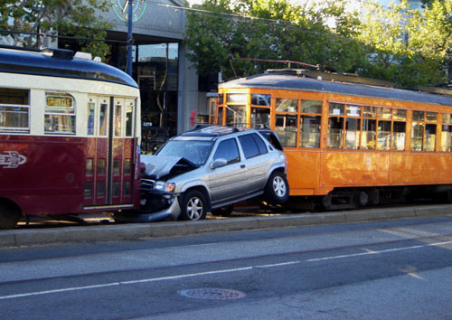
Gives new meaning to "compact car"Originally Posted by Snowman

So maybe not the best idea to have them sharing the same lane of traffic? But then again, could always be broadsided on a cross street....

 Participating Member

Gives new meaning to "compact car"
So maybe not the best idea to have them sharing the same lane of traffic? But then again, could always be broadsided on a cross street....
Participating Member

slight mod: the green and cyan lines kind of blend in on the bottom of the loop

VIP Member
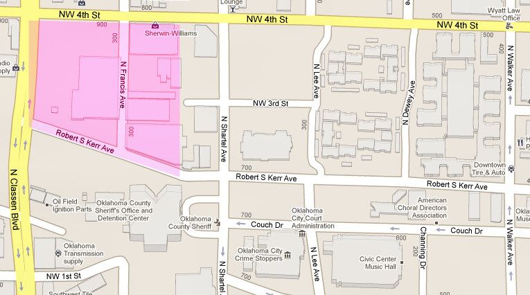
I don't know what was on the site of today's apartments but I don't think it was the car barn. Compare the image below with a contemporary map. At the time of the drawing, Classen didn't exist that far south and the western border was Olie. The drawing isn't clear enough to make out the east/west street that enters on the east side, but I think that it is 3rd, making the northern border NW 4th.
I probably don't have the pink car barn area extending far enough east, should be a little more.
A historic note: Although the ORC pretty much had a free hand in designating trolley routes, the City Council forbade street cars on Robinson in the downtown area, in case anyone is wondering why none appeared in the old trolley maps.
Participating Member
VIP Member

Thanks Doug, after I drew out the map the 'transit mall' was actually to the east of the Legacy apartment in an area bounded by 3rd, 4th, Walker and Harvey. Any idea why streetcars were not allowed on Robinson? It appears that the switch from Robinson to Broadway occurs around NW16th St. I always assume that Broadway Circle existed because the streetcars turned around there, but I guess not.
VIP Member
If I've known the reason, I've forgotten it. I just remember reading that the taboo was part of the charter granted by the city to ORC. I wouldn't be surprised if Broadway Circle was used for streetcars and think it was. But that's not Robinson, even if it's close.
VIP Member
According to the map, it looks like about 1/3 of Broadway Circle was used. It appears the street car was diverted from Broadway to Broadway Place (via Broadway Circle) before making the full move to Robinson at 16th St.
Of course, any streetcar lines established after the map was made are not shown and based on wide medians in other locations, there were either new tracks laid or tracks already abandoned at the time of the map. For instance, both maps show a line ending at NW20th and Grand (now I-44) but the wide median on 20th continues on to NW23rd and Meridian and includes a sweeping turn indicative of streetcar lines. My guess is that line was extended as the City grew west of Grand.
Participating Member
The wide median is located on 19th at I-44.
This is what you mean, correct?
Peace....
VIP Member
You're correct - 19th.
Participating Member
Why is Walker north of 4th not a good idea?
Seems like it would a good route. I am trying not to let my personal interests get involved. I own a property at 7th and Walker. So maybe I can't help it.
I have all along thought that north on Walker to 10th street was a good idea. The traffic circle isn't that big a challenge to deal with. Civil engineers deal with much larger tasks all the time.
Turn east on Walker at 10th and you can meet up on Broadway then south.
Last edited by Meaculpa; 02-11-2011 at 09:46 PM. Reason: Clarification
VIP Member
I posted mutiple pictures of streetcars going through traffic circles on the Robinson Ave Poll thread. To me that reason is a non-starter. It is done all over the world.
http://www.okctalk.com/showthread.ph...552#post401552
Here is but one example. You can see more at the link above.

Participating Member
[QUOTE=Meaculpa;
I have all along thought that north on Walker to 10th street was a good idea. The traffic circle isn't that big a challenge to deal with. Civil engineers deal with much larger tasks all the time.
Turn east on Walker at 10th and you can meet up on Broadway then south.[/QUOTE]
There's quite a deep discussion about this on the poll thread. But here is a copied reason from it.
Going across on 11th is far less invasive than the modifications that we would have to make to our existing circle.
Plus, I saw what the construction zone did to businesses in that area. I distinctly recall that two businesses didn't make it and several others lost half of their revenue. I'm not saying that the result wasn't worth it in the long run, but it was a painful project that "crippled" that area.
As a member of the MAPS Transit Subcommittee, it is our job to look out for the citizens who may be adversely impacted by our project. Everybody will have to endure some degree of pain while the project is built. But we are trying to minimize that with new expedited construction techniques. These new techniques can allow for one block to be completed in 14 -21 days.
That circle does not fall within the less invasive construction methods that we have at our disposal. Much less even "removing it" and putting signals in. It would be extremely detrimental to Midtown during the construction phases.
Signalizing the intersection would a bunch of ugly poles and quite frankly, I think that the train would be in peril of people who still don't know how to go around that circle and yield properly. In Europe, such circles are very much a part of the driving culture. Ours is still a novelty.
I will gladly, publicly state that I will rally against messing with it. What an absolute waste of recently expended taxpayer money for the circle on top of the idea. Sorry, this is just one of the few opinions I'm pretty certain about.
Participating Member
And I will say again (and get flamed for it) that spending tax dollars to put traffic circles back in when we spent tax money to take them out a few years ago is absurd and wasteful. The reason given for taking them out was they weren't safe. The reason for putting them back in, "due to advancements in technology, they are much safer". Huh?
Although I would love to see them all taken out, to spend more money to do so, again, isn't that wise (unless there are fatalities) and as Urban mentioned, the cost to businesses in the area can be crippling. Urban, as long as they use "water pipe" for the poles, think quite a few on here would love the idea (personally think the water pipe design looks as cheap as it probably is).
Guest
sid, I too don't want to derail this thread but I have been through this exact same discussion on another thread and I definitely disagree. I'm very familiar with roundabouts in Europe and I see nothing safer or more convenient about them or traffic circles compared to a traditional intersection. I see them as an accident waiting to happen.
Guest
You don't have to PM me any links. I've been there many times and driven on roundabouts and traffic circles. It can also be a nightmare for pedestrians. I know from first hand experience that they are not safer. It's always a nervewracking experience.
Participating Member
I don't want to "derail" the thread either, but I do remember the big battle that insued over it. The main reason proponents claimed that it was safer had to do with the speed at which a collision might occur. It was argued that a direct collision at 30 - 40 miles an hour was in a different realm to the 15 - 20 mph the circle practically forces everbody to go. Even running "straight through" the center would be slowed due to the higher elevation and all the landscaping.
Participating Member
Thanks for the info.
Call me easy, I'm satisfied with the reasoning.
Peace...
Participating Member
Yes, nearly all the manufacturers are developing this capability. Regarding
the bridge, it becomes an issue with "cutting" the foundation as well. BNSF will have to approve bridge mods and that is a huge question mark.
VIP Member
Check out the Guided Rail system in Nancy, France. It doesn't even have tracks on portions of its route.
http://homepage.ntlworld.com/c.fuller1/Tvr.html

Participating Member
http://transbaycenter.org/media-gall...ic-art-program
And now for something completely different, check out this video of San Francisco's planned Transbay Terminal. Oh, that OKC could have the vision to create something even remotely similar in and around the Santa Fe terminal area. What an excellent idea to incorporate the Streetcar and other forms of transit into the urban fabric of the city. OK, maybe not all white and nautically focused, but why not earthy yet eclectic to echo the heart of the Plains... a real eye-catcher and focal point of urban life in OKC.
Participating Member
...at a cost of "$4.185 billion"??
Guest
You're forgetting about the interest we'll draw on our Maps money, Larry. LOL
Participating Member
And you are forgetting the amount paid in interest on the borrowed portion of MAPS...LOL
Participating Member
Participating Member
From the Broadway/Robinson thread.
Well 1st, define "Uptown 23rd." Are we essentially talking about the Tower Theater?
I think the best response to all of you is that many members on the subcommittee are reaching the conclusion that "Bricktown to Midtown" is Phase 1. To translate that a bit more specifically, about 4 miles of track connecting the hub location area to St. Anthony's campus.
Several of us are thinking, leave the remaining estimated 2 miles in reserve to go into a "Phase 1b." This idea of "stretching" MAPS streetcar goals came directly from the skirmish with Council Members concerned with "reaching outside of downtown" to make a major current/future transit connections in a strategic neighborhood. Many of us think that a Phase 1b is orienting itself towards 23rd/Classen.
From that point, the streetcar could easily be expanded via a "Phase 2" to OCU, Plaza "on the return trip", or across "Uptown 23rd" to the Capitol thus coming within 4 blocks of the Paseo neighborhood.
Such "Phase 2" extensions could be paid for with several scenarios- our bids coming in less and we have more money in MAPS Transit, money is diverted from something else in MAPS that comes in under budget, a future bond issue, or Federal Matching funds.
If you can get to 23rd and Classen, you directly interface with the two busiest existing bus lines in the city and you set up a direct interface for a future BRT line (Bus Rapid Transit) as depicted in the 2005 Fixed guide-way Study) that would continue up Classen and further up NW Expressway into the NW side of town.
Add the Adventure Line at a modest price to that equation and you get a "giant V" of MAPS sponsored rail connectivity that stretches across several Wards and connects NW central, downtown, to far NE. Plus, going across on 23rd in the future connects the two far points of the "V".
There are currently 39 users browsing this thread. (0 members and 39 guests)
 Posting Permissions

 Reply With Quote
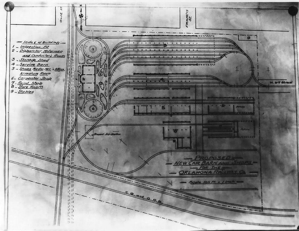


Bookmarks