

I understand the need for due-diligence, but if the Santa Fe station is not chosen someone better come with a very good reason. There are 6 parking lots within 500 feet of Santa Fe that would be ideal for residential development.

 VIP Member

I understand the need for due-diligence, but if the Santa Fe station is not chosen someone better come with a very good reason. There are 6 parking lots within 500 feet of Santa Fe that would be ideal for residential development.
VIP Member


my thoughts were answered by my friends Plansit and Kerry. It should be very well known on the forums and those who follow civic planning, sports, transit, and/or Seattle/PacNW politics. And all we have is one line, that barely gets 10,000 riders a day. Please don't make the same mistakes OKC. ... (IMO, you already made one with the Union Station debacle. ...).
Another thought of not following Seattle, is with regard to not investing in your infrastructure - (See Sonics/Thunder).
Oklahoma City, the RENAISSANCE CITY!
Participating Member
Hot Rod, what is your assessment of mistakes made with the streetcar in Seattle? I think one of the most important things we can do is understand what people would change in other cities, in an attempt to not repeat mistakes that have been made.
I do, however, disagree that Union Station was a debacle....if you are implying that not using it as our hub is the debacle. I think even outside analysts have seen that it is not the right location for a transit hub, although it could still conceivably be a stop on a variety of different types of transit lines, should the city grow significantly in that direction.
Participating Member
betts,
Was that outside analysis before the whole removal of rail lines issue? Not sure about the logistics (then or now) but purely from an aesthetics viewpoint, think Union Station is a much more attractive building than Santa Fe.
And I agree, look at others and learn from what works and what doesn't work (if applicable here)
Participating Member
There are still rail lines at Union Station. I agree that Union Station is much more attractive, but the location is impractical for a multimodal hub. Clearly the analysts think it is far less practical than the Santa Fe station for a hub location, but it still has the capability to be a stop. I believe there will be two lines still present, or at least one with space for a second. I'm sure someone will correct me if I'm wrong.
VIP Member
Larry and HotRod - you are barking up the wrong tree about Union Station. The group that wanted to keep primarily wanted to use it as a freight processing facility. They thought 50 semi-trucks a night would be linning up there to pick-up/drop-off freight. That is why they wanted to keep the railyard. It was laughable then and it is laughable now. If you think it would have made a good passenger hub then you don't know what a passenger hub is.
Participating Member
The whole Union Station thing is more of a philosophical debate rather than a technical one. The idea that massive rail infrastructure would be removed to make room for a "super-highway" just drives rail advocates and urbanites bonkers.
But Betts is right, to use it as THE rail hub for commuters is laughable. Primary commuting traffic is simply on a N/S axis- Edmond to Norman. Even Adventure Line and probably Yukon is coming in on the Northern alignment. Union station is on a E/W. Midwest City is unlikely to come in from the East on the UP line. Bus Rapid Transit is called for in the Fixed Guideway Study to serve the Yukon area unless the demand models change.
Airport is proposed as bus, but support for a rail alternative is gaining momentum. Even that connection would likely be a rapid streetcar going across on the new Boulevard and up through Stockyards to the existing alignment or up the Meridian Hotel corridor.
It is not that Union Station isn't attractive, its just not in the best place. In fact, its arguable that it was never in the right place to begin with for personal rail travel.
Participating Member
"probably Yukon"... Meant Midwest City
Participating Member
Urban and Betts, i don't disagree was just saying that while some tracks remain, some were removed. How many times have we gotten rid of something only to find out it was a bad idea and later try to bring it back (at considerable expense). Think it definitely needs to be a stop on the Streetcar (which would incorporate the MAPS 3 park) Ideally, would love to just switch the location of the 2 buildings.
VIP Member
I note that a meeting of the Modern Streetcar Subcommittee will occur later today (2/8) at 3:30 at 420 West Main Street, 10th Floor Conference Room. It is a public meeting so anyone can attend that wants to.
Of further note, in the PDF file containing the agenda that the minutes of the January 26 meeting are set forth, a part of which reads,
The subcommittee agreed and recommended an initial proposed alignment: Robinson from 13th Street to the new Boulevard, Broadway from 13th Street to Sheridan Avenue, 4th Street between Broadway and Walker Avenue, Walker from 4th Street to Sheridan Avenue, and Sheridan Avenue from Walker Avenue to E.K. Gaylord. Circulation will generally be clockwise on the north and counter-clockwise at the south end of the route.
Using the scale provided by Google maps and approximating as I have in the image below, and depending on whether a rail segment would exist on NW 13th between Robinson & Walker or not (one might presume that it would but the draft minutes do not so state), and unless I have made a major error in my counting, the roughly approximate lineal mileage of the tracks is:
- If no NW 13th, Robinson to Broadway segment exists: 17,500 feet, which is 3.31 miles
- If a segment exists on NW 13th between Robinson to Broadway, 17,900 feet, which is 3.39 miles
So, I presume that all or substantially all of the rail is double-tracked, although the minutes don't address that. The subcommittee has my complete confidence ... lots of good people on that subcomittee ... but I am disappointed that an extension into Bricktown is not present, such as on Sheridan from Gaylord to Walnut. That said, I'm sure that the subcommittee considered a Bricktown entry but for reasons that I'm not privy to decided against it.
The agenda itself isn't particularly specific:
I. Call to Order
II. Approve Minutes of the January 26, 2010 MAPS 3 Citizens Advisory Board Transit/Modern
Streetcar Subcommittee Special Meeting
III. Discussion/Action on Modern Streetcar Alignments and Transit Hub Locations
IV. Discussion/Action on Transit/Modern Streetcar Project
V. Comments by Subcommittee Members, Staff, and Citizens
VI. Adjournment
Participating Member
Interesting. Not bad for a starter track. I too hope that the 3.31 miles estimated will be doubled.
Thanks Doug.
I am not disappointed that Bricktown is left out of this initial plan, as I have always said that Bricktown does not need it.
VIP Member
That pink section is not double track - it is coupled track to create a transit mall. To quote Pete White, I think we will live to regret that.
Participating Member
^^ So if you take that all into consideration, how many miles of track is this initial plan?
Participating Member
I'll try to post a better map for you later that depicts circulation patterns and such.
Keep in mind that this is only the recommendations for the P180 area. That is why Bricktown, other parts of Midtown, and the larger system plan are not described in the minutes.
The recommendations from the last meeting are strictly the core system as it relates to P180 (although we did go ahead and approve the "transit mall" on Robinson Broadway above 6th as the central spine so that "it is out of the way").
More good stuff to come as further deliberation on details occur.
Participating Member
Initially, I felt exactly the way you do. Robinson was promoted by several people and I was biased against it on a personal level. It feels like a very sleepy street. But through this process, I have tried to detach myself from personal opinions and look at things dozens of times again, with fresh perspective. I know that most of appointed committee members have discipline and do the same. We all care to the extreme degree to make sure that this system will work from "day one".Originally Posted by sidburgess

Robinson has shown itself to be one of the few "axis" available that "cuts" all the way through and creates the "spine". The system really needs that axis. I say that from studying it from a operational point of view, turning radius at essential corners, and so on.
We felt that Broadway was so essential to be served as well that is counters as the "spine" going in the opposite direction. To make this "transit mall" work, we will have to build strong pedestrian connections between the two. They are so close together they will work as a single "unit."
Robinson has one of the busiest core destinations at Park/First National, and the most visited state destination, the Memorial at 5th. The "sleepy end" above 6th to 10th is already changing with Midtown Renaissance and there are plenty of empty lots ripe for development.
The "spine" continues easily all the way to Edgemere in later phases and South to Capitol Hill.
There are two principals constantly reinforced from my visits to other cities with modern streetcar systems. One is that '"couplets" are now the preferred mechanism to create development and spread walkability." 2nd, it doesn't matter where you put a streetcar (in terms of whether the existing street is "sleepy or not"), the streetcar almost magically changes and enlivens the environment around it. Robinson will be changed for our lifetime.
Regarding the size of the street- sometimes smaller more intimate streets are good experiences in a system. The streetcar goes with traffic, so it doesn't impede car travel as it shares the lane. The stops can be designed so that the tram leaves the travel lane. There actually is enough right-of-way there to do whatever we need.
VIP Member
I really really really hope we don't go with a transit mall using coupled track. A single spine of double track puts twice as much area with-in one block of bi-directional travel and uses the same amount of track.
VIP Member
To all, I see that the direct link to the Agenda PDF file doesn't work ... the address shown in the address bar when the file open must not be a constant. Anyway, go to this page and then find the meeting you're looking for.
Jeff, a few observations and questions from what you said:
1) As a suggestion, based on your comments above, the minutes do not appear to be complete since one cannot know what the description in the minutes mean, unless I'm missing something. As an example, I saw no mention that the track description was limited to Project 180 overlap but your comments explain that it was.
2) Is there any double track involved in what is shown in the map?
3) Is there a track segment on NW 13th between Robinson & Broadway?
Okclee, the track length depends on the amount, if any, double tracking is involved, and whether there is a segment on NW 13th between Robinson & Broadway, as I said before.
Kerry, I don't know about what you said about double tracking. It's not in the minutes. Jeff will tell us, I'm sure. But, as to what Pete said, his condemnation was much broader and included everything involved in the system, generally.
I look forward to hearing the progress made at today's meeting.
Participating Member
Regarding Bricktown in general- there are essentially three easy to identify candidates to "cross-over" from the core. Sheridan, Reno, New Boulevard. The reason we haven't gotten into that yet as we do not have "firm" cost estimates as to the reconstruction costs of Sheridan or Reno railroad underpass. That is one huge element that will weigh heavily on the design.
The second, we do not know the "technicalities" of how the streetcar might directly connect to the inter-modal hub as its final location out of the three identified has yet to have been determined. Even then, we will have to develop preliminary architectural and engineering models to determine exactly what the best "interface" options are.
There is one thing that is certain though, the new boulevard railroad underpass will be brand new and meet the height requirements that a streetcar needs to safely operate. We are going to have to "weigh" the cost of a Sheridan/Reno E/W connection against this "free" unassociated improvement that can be taken advantage of.
Participating Member
Pete came to the meeting you have referenced and stated that he "was pleased with where we are going." He stayed the entire meeting and saw how much detail and thought is going into all of this and I think that helped.
VIP Member
What you said re Pete, I know already. I was just responding to Kerry's point as to what Pete said when he made his negative comments. Thanks for your answers to my questions.
VIP Member
With a transit mall you only have one block that has direct access to two way travel. As we know, the distance people will walk drops of quikly as you move away from the tracks. Most people will not walk more than 2 blocks and hardly anyone will walk 3.
Here are the areas that would be within 1 block and 2 blocks of bi-directional travel. They use essentially the same amount of track.
Couplet
Double Track
As you can see the double track provides better service to more people.
VIP Member
How about a meeting report, Jeff, Jill, anyone?
Participating Member
Lots of good discussion. At the end, we reiterated that our "partial preferred route" encompasses the route/s outlined in your drawing above, with the addition of Walker between Sheridan and 4th Sts and the yellow area in question on 13th between Robinson and Broadway. That endorsement was to be discussed in the AA meeting today (which I suspect was cancelled) and we were going to address any comments or issues from them at our next meeting. People on the committee wanted to make sure that the public understands that this is not what we hope will be the full route, nor do we know with certainty that there won't be engineering issues that might influence the ultimate route. We've chosen not to address Bricktown until we have more information about the railroad bridges at 4th and Sheridan. The bridge at the Boulevard will be engineered so that it can sustain streetcar travel in both directions. Extension to Midtown or other areas in the city such as the Capitol, Paseo or Plaza District will be discussed at a later date and, of course, will be subject to funds available. Our primary focus, at this point in time, is areas subject to Project 180, as we want to have as much information available to them as possible. It is our hope that we can decrease construction costs by coordinating with Project 180. All this, as well, will ultimately have to be approved by the General MAPS committee and the City Council.
That is what I took away from the meeting. Hopefully Jeff will add his impressions or additions.
Participating Member
Nothing really to add. Very well described Jill. I will create a map when I have the time that describes all of this in greater detail with captions at the "stub ends." Doug, with the exception of the missing piece between 4th and Sheridan on Walker, these are the coridoors that we would like to "protect" in the core area. When I say "protect", I mean make logical preparations in P180 to accept a streetcar system.
During the meeting, I challenged people to start thinking about logical stop locations that might also be "protected."
What locations do OKCTALK members think have to be absolutely served on these potential coridoors? Every 3 blocks is a general "rule of thumb."
Participating Member
I was able to attend the meeting, as an observer. I'm not on the subcommittee.
What I took away from the meeting is exactly what betts wrote above.
I'm sure many on this thread know who is on the committee. But if you are one who does not know allow me to comment on a few of the committee members.
Jill Adler- She is a class act. Very knowledgeable and when she speaks her words are well chosen and precise.
A real asset (excuse me for referring to a person as an asset, but you know what I mean)
Jeff Bedzeck (sp)- here's a guy with passion! He is well versed in all transit
There was a lot of talk about transparency and the proper wording of maps and drawings so the public doesn't get led astray by misunderstanding the language of the committee.
Hope this post helps somebody. You guys are all so knowledgeable you probably already know all of this.
Peace.....
Last edited by Meaculpa; 02-09-2011 at 12:16 PM. Reason: Remove a line
There are currently 38 users browsing this thread. (0 members and 38 guests)
 Posting Permissions

 Reply With Quote
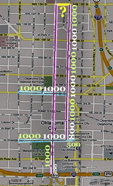


Bookmarks