Widgets Magazine
Page 1 of 4 1234 LastLast
Results 1 to 25 of 80

Thread: Capitol Hill Definition

  1. Default Capitol Hill Definition

    Here's a question that bears upon what pics I or others might stick in this thread:

    What IS Capitol Hill, exactly, if it has any common accepted definition? South of the east/west railroad tracks, west of the north/south Santa Fe tracks ... I suppose (but am not certain) that those two "boundaries" are correct.

    But what about south and west? Welge's book includes Packingtown as part of his Capitol Hill chapter, but how would that be so? Just proximity? The last page of the chapter shows a picture of the Oklahoma City Community College ... I surely don't think of Capitol Hill including that area.

    Maybe I'm wearing glasses or blinders that need adjustment. Anyone know of a commonly accepted definition of Capitol Hill?

  2. #2

    Default Re: Capitol Hill Pics

    Quote Originally Posted by Doug Loudenback View Post
    Here's a question that bears upon what pics I or others might stick in this thread:

    What IS Capitol Hill, exactly, if it has any common accepted definition? South of the east/west railroad tracks, west of the north/south Santa Fe tracks ... I suppose (but am not certain) that those two "boundaries" are correct.

    But what about south and west? Welge's book includes Packingtown as part of his Capitol Hill chapter, but how would that be so? Just proximity? The last page of the chapter shows a picture of the Oklahoma City Community College ... I surely don't think of Capitol Hill including that area.

    Maybe I'm wearing glasses or blinders that need adjustment. Anyone know of a commonly accepted definition of Capitol Hill?
    ---------------------------------------------------------------------------
    My conception as from a child...was 29th and penn north to aboaut 18th st.
    and then East to Shields....Past Shields was a whole nuther world....I'll get my father-in-law in a talking mode and find out for sure.....the retail area went from the West of shields to Walker (remember 25th st. was called Commerce in that area...)I'll show your book buddies today...I'm getting confused...you know, old-timers disease.....

  3. #3

    Default Re: Capitol Hill Pics

    Quote Originally Posted by Generals64 View Post
    ---------------------------------------------------------------------------
    My conception as from a child...was 29th and penn north to aboaut 18th st.
    and then East to Shields....Past Shields was a whole nuther world....I'll get my father-in-law in a talking mode and find out for sure.....the retail area went from the West of shields to Walker (remember 25th st. was called Commerce in that area...)I'll show your book buddies today...I'm getting confused...you know, old-timers disease.....
    I am looking for an old map I found years ago. If I remember correctly North boundary was the river. south 29. I just don't remember east/west divider.
    My family have lived in the College Hill Addition for........I have not been able to find information on the addition........

  4. #4

    Default Re: Capitol Hill Pics

    Quote Originally Posted by Doug Loudenback View Post
    Here's a question that bears upon what pics I or others might stick in this thread:

    What IS Capitol Hill, exactly, if it has any common accepted definition? South of the east/west railroad tracks, west of the north/south Santa Fe tracks ... I suppose (but am not certain) that those two "boundaries" are correct.

    But what about south and west? Welge's book includes Packingtown as part of his Capitol Hill chapter, but how would that be so? Just proximity? The last page of the chapter shows a picture of the Oklahoma City Community College ... I surely don't think of Capitol Hill including that area.

    Maybe I'm wearing glasses or blinders that need adjustment. Anyone know of a commonly accepted definition of Capitol Hill?
    I have never heard that Packingtown was a part of Capitol Hill. I am going to have to do some looking but I may find the boundaries. I guess what matters is what are you asking. Capitol Hill High School boundaries are wide. When I was in school it ran from about High to Portland (or further). North/south is tougher. I am going to say 15th to 44th but I know some CHHS students came from some areas between 44th and 59th. CONFUSED???????

  5. Default Capitol Hill Definition

    Rather than clutter up the Capitol Hill Pics thread with this discussion, I thought it best for the "definition" topic to have its own thread ... and, M, maybe you will consider moving some of the posts in the Pics thread here, those which relate to the definition issue, so that the Pics thread pretty much stays a Pics thread.

    My purpose is to see if we can arrive at a consensus as to the boundaries of Capitol Hill. Looking around on the internet and hearing the view of forum members who have so far expressed themselves on the boundaries of Capitol Hill, and seeing that it appears to be pretty much a subjective thing (particularly on the Internet but also in sources like Welge's Oklahoma City Rediscovered book), I figured that, "Hey, why can't OkcTalkers make the call," and, then, when I get around to doing a long blog article on Capitol Hill, I will use that definition and credit the forum as the source. Everyone else pretty much makes up his/her own definition; therefore, so can we.

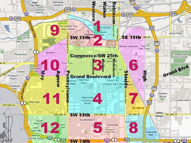
    I've put together a map, below, marking of what I thought were logical areas either to include or exclude as part of the definition. I've intentionally made it larger that I suppose most would say really IS part of the Capitol Hill area. For example, I doubt that anyone would seriously think that the Crossroads Mall area (8 in the map) is part of Capitol Hill. But, then, I wouldn't have thought that Welge would have included Oklahoma City Community College in area 12, but he did.

    Here's the map:


    It is evident that the definition has changed over time. Obviously, those who incorporated Capitol Hill as a city back in 1905 had a very precise definition. However, I doubt that many if any would limit the definition to that small area today even if most everyone would agree that it is the "heart" or "kernel" area. According to Charles G. Hill's nice Dustbury mini-article at The Vent #421 , Capitol Hill was annexed by Oklahoma City in 1911.

    Since an objective definition does not exist, I'm thinking that the opinions of those who live or have lived in south of Interstate 40 may be the most reliable sources in coming up with a good subjective definition. If such people considered that they did, or did not, live in Capitol Hill, I'd suppose that information to be very important since it would be part of how they identify themselves. To me, that's more important than the opinion of me (for example) who never lived in and don't identify myself as being a "Capitol Hill person" except in the broad sense that I identify anyone in Oklahoma City or its immediate environs (e.g., Edmond) as being my Oklahoma City brother or sister, if you get my drift.

    So, what's your opinion? Which parts in the above map are part of Capitol Hill and which are not?

    My own present vote (I can be persuaded differently) would be

    Capitol Hill ...
    • For sure: Area 3
    • Probably: Areas 4 & 10
    • Well, maybe: Areas 1, 2 & 9

    Not Capitol Hill: Areas 5, 6, 7, 8, 11 & 12

  6. #6

    Default Re: Capitol Hill Definition

    Quote Originally Posted by Doug Loudenback View Post
    Rather than clutter up the Capitol Hill Pics thread with this discussion, I thought it best for the "definition" topic to have its own thread ... and, M, maybe you will consider moving some of the posts in the Pics thread here, those which relate to the definition issue, so that the Pics thread pretty much stays a Pics thread.

    My purpose is to see if we can arrive at a consensus as to the boundaries of Capitol Hill. Looking around on the internet and hearing the view of forum members who have so far expressed themselves on the boundaries of Capitol Hill, and seeing that it appears to be pretty much a subjective thing (particularly on the Internet but also in sources like Welge's Oklahoma City Rediscovered book), I figured that, "Hey, why can't OkcTalkers make the call," and, then, when I get around to doing a long blog article on Capitol Hill, I will use that definition and credit the forum as the source. Everyone else pretty much makes up his/her own definition; therefore, so can we.

    I've put together a map, below, marking of what I thought were logical areas either to include or exclude as part of the definition. I've intentionally made it larger that I suppose most would say really IS part of the Capitol Hill area. For example, I doubt that anyone would seriously think that the Crossroads Mall area (8 in the map) is part of Capitol Hill. But, then, I wouldn't have thought that Welge would have included Oklahoma City Community College in area 12, but he did.

    Here's the map:


    It is evident that the definition has changed over time. Obviously, those who incorporated Capitol Hill as a city back in 1905 had a very precise definition. However, I doubt that many if any would limit the definition to that small area today even if most everyone would agree that it is the "heart" or "kernel" area. According to Charles G. Hill's nice Dustbury mini-article at The Vent #421 , Capitol Hill was annexed by Oklahoma City in 1911.

    Since an objective definition does not exist, I'm thinking that the opinions of those who live or have lived in south of Interstate 40 may be the most reliable sources in coming up with a good subjective definition. If such people considered that they did, or did not, live in Capitol Hill, I'd suppose that information to be very important since it would be part of how they identify themselves. To me, that's more important than the opinion of me (for example) who never lived in and don't identify myself as being a "Capitol Hill person" except in the broad sense that I identify anyone in Oklahoma City or its immediate environs (e.g., Edmond) as being my Oklahoma City brother or sister, if you get my drift.

    So, what's your opinion? Which parts in the above map are part of Capitol Hill and which are not?

    My own present vote (I can be persuaded differently) would be

    Capitol Hill ...
    • For sure: Area 3
    • Probably: Areas 4 & 10
    • Well, maybe: Areas 1, 2 & 9

    Not Capitol Hill: Areas 5, 6, 7, 8, 11 & 12
    -------------------------------------------------------------------------
    Doug:.. I believe that the Not Capitol Hill Areas you posted would be truthfully NOT actually part of Capitol Hill...But, S. Western and Walker are not on the map or I'm going blind.....maybe old....

  7. Default Re: Capitol Hill Definition

    You're not as old or as blind as me! I left out streets I thought people would figure out to keep the map uncluttered. I've now added Western, Walker, and Robinson. You may need to press your refresh key (F5) to see the revised map. Does that help?

  8. #8

    Default Re: Capitol Hill Definition

    This might cause problems, but here goes anyway. I don't think you can get a real feel and understanding of Capitol Hill unless you concentrate on the core area. Businesses and people. That small Commerce St. area, Shields to Western, and the river to SW29th. There was and still is a hatred of anything north. Or let's say north of Reno. I am 53 and it started before I came along. I think the annexation vote is a big reason why. Don't know if you are aware but residents of Capitol Hill, Oklahoma were not allowed to vote. Only residents of Okc.
    A number of people I know who were raised in Capitol Hill still would not move north for any reason. And they will tell you they are proud to be Capitol Hill/Southsiders.
    I have always wanted to write a book because I love research and writing. Maybe I'll do one...................................
    Last edited by papaOU; 03-29-2009 at 12:52 AM. Reason: rephrase

  9. #9

    Default Re: Capitol Hill Definition

    Quote Originally Posted by Generals64 View Post
    -------------------------------------------------------------------------
    Doug:.. I believe that the Not Capitol Hill Areas you posted would be truthfully NOT actually part of Capitol Hill...But, S. Western and Walker are not on the map or I'm going blind.....maybe old....
    NO!!You went to Grant!!

  10. Default Re: Capitol Hill Definition

    Quote Originally Posted by papaOU View Post
    This might cause problems, but here goes anyway. I don't think you can get a real feel and understanding of Capitol Hill unless you concentrate on the core area. Businesses and people. That small Commerce St. area, Shields to Western, and the river to SW29th. There was and still is a hatred of anything north. Or let's say north of Reno. I am 53 and it started before I came along. I think the annexation vote is a big reason why. Don't know if you are aware but residents of Capitol Hill, Oklahoma were not allowed to vote. Only residents of Okc.
    A number of people I know who were raised in Capitol Hill still would not move north for any reason. And they will tell you they are proud to be Capitol Hill/Southsiders.
    I have always wanted to write a book because I love research and writing. Maybe I'll do one...................................
    As far as I'm concerned, there's never a problem about saying what you think or feel. But, I'm wholly unfamiliar with the 1911 Capitol Hill annexation. But annexation by Oklahoma City of gobs of territory by surrounding it and then annexing in much later times ruffled many feathers, too ... see Doug Dawgz Blog: Oklahoma City Area History ... those annexations likely caused the same sensations in not a few. But, if you're still holding a grudge since and after 1911 on behalf of your ancestors, well ... there is nothing that I could or would want to say about that which would possibly matter!

    But ... what would you say about the definition -- just use the original Capitol Hill city boundaries which were fairly small, when those living then apparently got pretty well pissed by what Oklahoma City did without their permission? Even though Capitol Hill High School is located at 500 SW 36th Street (at that point Grand Blvd., i.e., outside the original Capitol Hill city boundaries)?

  11. #11

    Default Re: Capitol Hill Definition

    Just my sense over the years, without ever living in the area:
    3 - well, duh.
    The rest, even right up close to the borders of 3, seem a bit different from the core when I travel that area.
    I'm more inclined to view 2 with 1 and 4 with seven than find either meshing with 3 wheni think on it.

  12. #12

    Default Re: Capitol Hill Definition

    hmmm....

    here's what i think...

    #1 is out. i always thought that the river represented a hard boundary of anything considered 'south' and therefore anything that could be considered 'capitol hill'

    #9 is out. packingtown, in my opinion, always had its own identity as evidenced by streets and subdivisions that had variations of the packing firms' names.

    #12 is out. in fact, the western portion of that was incorporated as 'mclemore' from the '50s into the early '60s when it was annexed.

    while it certainly has blurry boundaries as you suggest... i'd say that #3 & #4 are definitely part of capitol hill. it'd be difficult for me to call anything east of shields capitol hill, but if memory serves, there is/was a touristy/nostalgic sign on the west side of shields that said something to the effect of 'welcome to capitol hill'... so evidently many people felt that shields was a gateway into the district. the west boundary, though, is really blurry to me... not sure i could nail it down, but i'd feel it ended by penn... but that's more of a loose feeling than anything.

    one question... you say that there were distinct boundaries in the 1905 incorporation... do you know what those boundaries were?

    -M

  13. #13

    Default Re: Capitol Hill Definition

    found the sign... it's on the nw corner of se 25th & shields.

    here's a link to google streetview -M

  14. Default Re: Capitol Hill Definition

    M, no I don't seem to have a map or plat of the incorporated city. I looked in the 1905 Township maps but it doesn't seem to show municipalities. I've looked in the 1906 Sanborn maps but they doesn't show the Capitol Hill are in the Oklahoma City map (which goes no further south than the river) and a separate map isn't present for Capitol Hill. The next sequential Sanborn map is 1922, so they aren't helpful with this. So, striking out so far, but I'm still looking.

  15. Default Re: Capitol Hill Definition

    ON EDIT: The map I got all hot and bothered about is Capitol Hill in Logan County. Bummer. I'll leave the post, but modify it.

    I've been scouring OHS's Star Archives this morning for anything I could find on Capitol Hill, and I've saved quite a few of the small pics available there.

    But, [I first thought] here's the biggie ...

    A PDF file is there showing the Capitol Hill Townsite in 1892 ... whether this became official I don't presently know, but if so this may mean that what I've read before about incorporation in 1904 or 1905 is incorrect (although the information may also be reconcilable). [Error - the map is Capitol Hill in Logan County]

    Regardless, this is a map lover's delight (I'm particularly thinking of you, M). I've extracted the image from the PDF file and here it is:

    Largest File Size (1692 x 3999 px): http://i8.photobucket.com/albums/a49...nsite_1892.jpg

    Large File Size (1024 x 2420 px): http://i8.photobucket.com/albums/a49..._1892_1024.jpg

    The 800 x 1891 px version is shown below:


    ON EDIT: WRONG WRONG WRONG. This is Capitol Hill in LOGAN COUNTY. Too bad. Back to the drawing boards.

  16. Default Re: Capitol Hill Definition

    Doug, I recall running across a map once in the downtown library's archives of the Capitol Hill Beacon. I wonder if Buddy could help out on this one?

  17. Default Re: Capitol Hill Definition

    OK, getting warmer. Though not nearly as sexy as a great townsite map would have been, I've located this article in the Metropolitan Library Images collection (you may need to press your refresh button - F5 - after clicking the link). Part of the article reads:

    "South of the River" - The Community of Capitol Hill
    by Jana C. Hausburg

    It should have been the home of the state capitol. At least, that was the plan. Home to a promising hill overlooking much of Oklahoma City, the area was named accordingly by B.R. Harrington, a newspaper correspondent for the Wichita Beacon. In 1900, he purchased the land from Miss Tryphosa Boyd, who had been among the early settlers attracted to the area after the Land Run of 1889, when Oklahoma lands were opened by the Federal Government. Her deed bore the signature of President Grover Cleveland.

    Harrington platted the 160-acre tract near the old Santa Fe Trail and staked out individual lots for sale. His purpose, said Harrington, was to give "sober and industrious mechanics an opportunity to secure homes."

    First Bridge Over the North Canadian, approx. route of Robinson Ave.
    click for larger view
    The site originally extended from Walker to Santa Fe, and from what is now called SW 22nd to SW 29th, the north boundary being the North Canadian River. Later, it grew to incorporate Penn Ave. on the west, SW 44th on the southern edge, stretching all the way to I-35 on the east.

    "At the time Capitol Hill was surveyed, I used a county surveyor, a fellow named Williamson," Harrington was quoted in the Capitol Hill Beacon 60th Anniversary edition. "He asked me what I was going to call the place. I said, ‘Why, Capitol Hill, of course´." Thus, Capitol Hill had the distinguishing characteristic of being the only town in Oklahoma considered as a site for the state capitol before it was even a city. Unfortunately, despite vigorous campaigning on the part of Harrington and his associates, the state capitol was located elsewhere.
    * * *
    Before eventually becoming a suburb of Oklahoma City, Capitol Hill was an incorporated town, with a decree of incorporation being granted on May 3, 1904. George Flanagan was the first mayor of Capitol Hill, from 1906-1910, and it was during his term that citizens of the area petitioned Oklahoma City for annexation. The vote was 1407 to 188 for annexation, although only citizens of Oklahoma City were allowed to vote; Capitol Hill residents were prohibited from taking part in the election.

    Capitol Hill Senior High School Reading Room, 530 SW Grand Blvd.
    click for larger view

    On December 6, 1909, Capitol Hill became part of Oklahoma City, bringing to the coffers a bonus of more than $12,000 - clearly a boon for Oklahoma City government. However, some Capitol Hill residents had complaints.

    "Annexation delayed our improvement and deprived us of many things we could have had long ago," complained an unnamed citizen in the July 1910 issue of the Capitol Hill Beacon. "We could have had sidewalks, paving and a city hall. Instead, our enemies stuck on you a 15 ½ mill tax levy, most of which was later spent on the north side."

  18. #18

    Default Re: Capitol Hill Definition

    But, if you're still holding a grudge since and after 1911 on behalf of your ancestors, well ...

    The annexation was only the start. Capitol Hill through the years has been Okc'c redheaded stepchild. I think even the Grant and S.E. readers would agree.


  19. #20

    Default Re: Capitol Hill Definition

    Quote Originally Posted by Doug Loudenback View Post
    OK. You win.
    Thanks Doug:....The southside of Okc has contributed many things to the growth of Oklahoma City and Oklahoma City Proper. We as citizens in the area should be proud and excited by the fact that the recognition of Capitol Hill is coming light. Most people in OKC don't even realize the advancement that the people of South OKC have put forth. Generals64 (U.S. Grant Generals that is...Southside school).

  20. #21

    Default Re: Capitol Hill Definition

    I am still looking for that darn map of the original Capitol Hill. I know where everything of mine is until I need it!!

  21. #22

    Default Re: Capitol Hill Definition

    Isn't the area just south of Capitol Hill/29th actually known as Hillcrest? I don't think it is part of Capitol Hill.

  22. #23

    Default Re: Capitol Hill Definition

    I snagged this from the Beacon.

    The Capitol Hill area, across the river from downtown Oklahoma City, was settled around 1900, and was incorporated as a city in 1905, though Oklahoma City proper had already spread south of the river itself — Wheeler Park was established in 1903, with the first incarnation of the Oklahoma City Zoo following in 1904. (A flood destroyed much of the park in 1923; the Zoo was relocated across town.)

    In 1911, Capitol Hill was annexed by Oklahoma City, but was never quite wholly absorbed; the southside area had its own chamber of commerce, its own community newspaper (the Beacon, still being published), even its own downtown along Commerce Street, which hardly anyone, even today, calls Southwest 25th Street, even though technically that's what it is.

    How the two sides of the city grew so far apart over the years is open to debate. It seems reasonable to infer that since city offices, located downtown, are north of the river, the movers and shakers of Oklahoma City's early years tended to spend most of their time, and presumably their efforts, on areas north of the river. W. H. Dunn, as far back as 1909, had envisioned a circular boulevard surrounding the city, and the circle was incorporated into the city plan around 1930. But it wasn't all that circular, nor was its center near the center of town; the northern loop of the eventual Grand Boulevard was built more than five miles north of downtown, beyond NW 63rd Street, but the southern loop was less than a mile south of Commerce Street, along SW 36th Street. It's hard to imagine this asymmetry being accidental.

    Whatever the reasons, Capitol Hill eventually went into a tailspin. Many businesses closed; others relocated farther south, closer to the proposed Southwest Expressway, now I-240, which began construction in 1961. And in 1972, the Finger Plan, intended as a remedy for school segregation, proved to be the impetus for massive white flight, much of it to the Moore school district, whose northern boundary was SW/SE 82nd Street.

    Note: I removed one paragraph dealing with the Little Flower Community.


    And when in recent years the Latino population began to grow beyond the immediate vicinity of Little Flower, they moved to the west, toward the Stockyards, and north from there; and to the south, across the river, and into Capitol Hill. The Capitol Hill Elementary School, built in 1920 at SW 27th and Robinson, is these days about 60 percent Hispanic; Heronville, built in 1928 on SW 29th east of Blackwelder, is about 75 percent. (Heronville, incidentally, is getting a major facelift and expansion from MAPS for Kids.) None of this, of course, was predicted in that 1930 city plan. But cities, being composed of people first and infrastructure second, have a way of evolving that defies easy prognostication. If you've been thinking of Oklahoma City as a white-bread Protestant sort of place, you haven't been paying attention. One of the reasons I write these pieces is simply that for many years I wasn't paying attention either.

    Update: A reader has chided me for leaving the impression that this side of the city was always some sort of Spanish-speaking enclave, which of course it wasn't; it was around 1990 (hence, "in recent years") before the Mexican-American community made any serious inroads south of the river. One continuing presence, though, has been Catholicism: Mount St. Mary School on Shartel north of 29th dates to before statehood, and has been an anchor for the southside Catholic community, then largely Irish, now less so, pretty much ever since.

    The "Vent" #421
    15 Janurary, 2005
    Updated 28 December, 2007

    | Vent menu | E-mail to Chaz

    Copyright © 2005, 2007 by Charles G. Hill

  23. Default Re: Capitol Hill Definition

    Quote Originally Posted by papaOU View Post
    I snagged this from the Beacon.
    Thanks, good read. What is the Beacon issue date? I'd like to go to the library and scan it.

    I'd planned to go to the Norick Library today but I went to sleep instead during the OU basketball game ... before and after, I was copying Capitol Hill photos from the OHS Star Archives and researching the Oklahoman's archives for early-day Capitol Hill stuff. I started at the earliest available (1901), went through 1907, skipped to the period that the annexation election occurred (on 12/6/1909) through 1911.

    I've set up a Capitol Hill folder in my Photobucket account and that's where I'll stick all this stuff for those who are interested: capitolhill pictures by DougLoudenback - Photobucket . It's got quite a lot in it already.

  24. #25

    Default Re: Capitol Hill Definition

    Here is the link to the article. I say it was from the Beacon but now I am not sure.

    The Vent #421
    There had almost always been a community of transplanted Mexicans in the city. ... 421. 15 January 2005. Updated 28 December 2007 | Vent menu | E-mail to Chaz ...The Vent #421 - Cached

Thread Information

Users Browsing this Thread

There are currently 7 users browsing this thread. (0 members and 7 guests)

Similar Threads

  1. Capitol Hill Pics
    By Doug Loudenback in forum Nostalgia & Memories
    Replies: 25
    Last Post: 04-20-2009, 09:12 AM
  2. Group aims to reinvigorate Capitol Hill
    By metro in forum General Civic Issues
    Replies: 2
    Last Post: 09-25-2007, 09:52 PM
  3. Capitol Hill Needs a Web Page
    By downtownguy in forum General Civic Issues
    Replies: 11
    Last Post: 12-06-2005, 12:22 PM
  4. Capitol Hill neighborhood redevelopment under way
    By Proactive Volunteer in forum General Civic Issues
    Replies: 3
    Last Post: 02-25-2005, 09:00 AM
  5. Rebirth of Capitol Hill
    By Patrick in forum General Civic Issues
    Replies: 3
    Last Post: 11-23-2004, 09:09 PM

Bookmarks

Posting Permissions

  • You may not post new threads
  • You may not post replies
  • You may not post attachments
  • You may not edit your posts
  •  
Single Sign On provided by vBSSO