

Extremes as of 2 pm, 2/12, in the Texas weather. The wind chill index in the northwest Texas panhandle is -2 while the heat index at Brownsville is 97.
All of North Dakota is below zero.


Active pattern continues with two more strong cold fronts moving through on Saturday and Tuesday. Brief warm-ups in between but those will be tempered by consistently strong winds. Appears to be the potential for more winter weather next week, exact details TBD.


Skies are clearing heading into sunset. Result will be Thursday morning temps near 10F.

Forgive me - I wasn't trying to come across as rude in that reply lol. I would definitely say you're one of us by now. I think we're all starting to sit on the edge of our chairs hoping that an early Spring nabs us. I came out of work today and the cold wind hit my slacks and I heard my knees groan.
Spring will feel like a distant memory next week. Another Arctic front comes through Saturday with a chance of rain mostly E of I-35 then a stronger system arrives next Tuesday 2/18. That combined with another Arctic front will bring winter weather possibly heavy snow in some areas. The air behind the front could be the coldest all season. Luckily since it is late Feb we should warm up again fairly quickly by the following weekend.


Cold.
That's it. That's the forecast.


And here we are again. Thursday 4 1/2 days out and local media is already starting too put out snow fall totals. We never learn do we. Oh course they say this could change. Yeah you think SMH
Something to remember. Cold air is dry air.


Ch 5 said 108 hours of below freezing temps.


I know it's literally the last 2 snapshots on the GFS, but it looks like an early spring pattern is trying to show up in early march. Dewpoints aren't great, but you're starting to see the possibility of some southwesterly flow again. Hopefully it holds! I'm ready for some warmer temps!


Snowfall amounts will likely be modest, but the strength of the cold snap is no joke. Wind chill values will probably be in the negative teens overnight Tuesday.


Yes, extremely low windchills and some dry blowing snow. Meaningful snow accumulations look most likely across NE OK.


Maybe a brief period of moderate to heavy snow Saturday night with wrap-around action on the back of the low. Nothing significant except temporary reduced visibility.


1-3 for the metro on Tuesday as of Saturday which it will change again.
Nice little sleet/snow “storm” in west okc/yukon


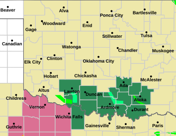
Currently (Sunday morning, 7:00 am central), central and western Oklahoma have an Extreme Cold Watch:
..EXTREME COLD WATCH IN EFFECT FROM TUESDAY EVENING THROUGH THURSDAY MORNING...
* WHAT...For Wednesday morning, dangerously cold wind chills as low as 15 to 25 below zero will be possible across northern and central Oklahoma and wind chills as low as 10 below zero will be possible across southern Oklahoma and western north Texas. For Thursday morning, dangerously cold wind chills as low as 10 to 15 below zero will be possible across northern and central Oklahoma and wind chills as low as 10 below zero will be possible across southern Oklahoma and western north Texas.
For northern and northeastern Oklahoma, there is a Winter Storm Watch:
...WINTER STORM WATCH IN EFFECT FROM LATE MONDAY NIGHT THROUGH LATE TUESDAY NIGHT...
* WHAT...Moderate to heavy snow. Total snow accumulations of at least 4 inches are possible. Winds could gust as high as 35 mph.


Looks like a week of dripping my faucets.
Winter storm watch in blue.


My forecast. 1-15 inches. There all my bases are covered. LOL I have seen anywhere from dusting to 1 inch to Morgan and his 2-4 with drifts. NWS is around 2 by the way but why listen too them when we can have the click bait going crazy.
There are currently 26 users browsing this thread. (0 members and 26 guests)
Bookmarks