I feel like we’re just being marinated for the heat later on this week.
I feel like we’re just being marinated for the heat later on this week.
Not too often that you see tropical storm feeder bands moving across Oklahoma.
HRRR 5 pm Monday

Pretty decent rainfall for early-July across the state. SE OK has been the only area really left out but they are likely going to see 2-3" from Beryl today with some of the rain bands making it as far west as Tulsa. Hot and dry weather returns this week into next week.


^
Mesonet only has two stations in Oklahoma County; therefore, the correlation between what they report and what any particular area actually receives is almost nonexistent.


https://www.mesonet.org/about/mesonet-sites
There used to be a Mesonet site at Britton & Broadway Extension, but it's been retired since 2018 - "Land was reclaimed by property owner." There also used to be a Mesonet site in west OKC (at OSU-OKC maybe?) retired in 2015 for the same reason.
^^^^^^^^^
You can find out quite a bit by clicking through to the individual decommissioned sites, including photos, panoramic photos of the sites, topographic maps, etc.. I also went one step further in the case of the OKCW retired site, looking at Google Maps images from before it was retired.
In the case of OKCN (Britton and Broadway Extension), it was on land that is now being developed as The Half. In the case of OKCW (OSU OKC), it was on land that required extensive site work for the new building they built on campus in 2015.


If you're feeling nosy, poke around on https://ambientweather.net/. These are private weather stations reporting to the internet... you can hide your actual location so it might not be full accurate, but the hiding feature still places the map dot within a few miles...
As we're going down memory lane, OKC and the OK Mesonet partnered for a few years on an OKC-specific micronet. It was great. https://www.mesonet.org/research/pas...t%20(a%20joint


McCurtain and LeFlore counties were the biggest beneficiaries from Beryl. If it moves few hundred miles west it erases the drought across Texas and Oklahoma, but alas it didn’t. Definitely thankful for the rainfall this past week, it may be a while before we see anything meaningful again as the Heat Dome returns.


Seeing potential dome break-down coming around July 18. Until then, nothing too exciting - getting hotter and drier every day.


A dome break a week from now would be nice. At least we probably wouldn't be hitting any record breaking stretch of it being over 100 degrees.
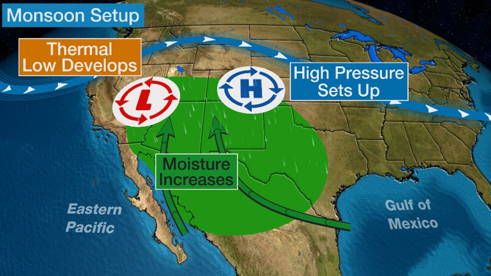
As much as we hate/complain about "the dome" it's an important weather feature for our continent since it brings the monsoon to the southwest U.S. Some areas get basically all of their annual precipitation from this, which is caused by the high pressure dome over the southern Plains.

Ambient Weather is pretty great - I use it with my personal weather station. AFAIK though it only works with Ambient Weather branded weather station gear so coverage is slightly more limited - for example, mine is the only station reporting data within the inner southside loop on that site. There's also a similar service from https://www.wunderground.com that is compatible with more brands of gear so there's a bit better coverage on that site. Mine doesn't currently report to WeatherUnderground but I'm considering setting that up too.
For reference, I've recorded 2.83" of rainfall since the beginning of the month.
Very hot and dry conditions for the next 5 days until a cold front moves south on Wednesday 7/17. Temps around 100 each day with continued high humidity.
Decent rain chances across the state look likely Wednesday into Thursday - some models are showing most rain in northern OK while others are showing SE OK. Temps in the 80's behind the front and maybe a stormy pattern developing for the end of July...


Cold front still expected mid-day Wednesday with storms expected to fire ahead of it mainly in northern OK into KS starting tomorrow afternoon. Slight risk of severe weather, mainly wind. Another round of storms expected as the front pushes through on Wednesday. Rainfall totals don't look great but we'll take what we can get in mid-July.
GFS rainfall through Friday
Another storm moves through this weekend bringing more widespread storm chances then a series of storms will move through as the pattern shifts. This type of pattern is very unusual for late-July - look at these potential rainfall totals through the end of the month..

Had a whopper of a water bill, so fingers crossed on some of that weekend precipitation!


I’ll eat my hat if we actually get up to 104 today like what’s currently being forecast. Think we’ll struggle to break triple digits with the current cloud cover.
At least isolated thunderstorm coverage appears possible late this afternoon. A more organized complex could make a run at the Metro overnight, but best chances seem to be a bit to our north. Damaging winds will be the main threat with both rounds.
Extended cooldown starting tomorrow. Think tomorrow is trending drier, and then Thursday and Friday appear dry as well. Much better storm chances and even cooler temperatures starting Saturday Afternoon. Would think we get at least one solid round of precipitation between Saturday and the middle of next week.
There are currently 10 users browsing this thread. (0 members and 10 guests)
Bookmarks