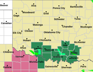
Here's a crazy one for you: There's a reverse-rotating (anticyclonic) tornado in s. Oklahoma right now near Grandfield.
Did *anyone* see these tornadoes coming today? Wow.
Here's a crazy one for you: There's a reverse-rotating (anticyclonic) tornado in s. Oklahoma right now near Grandfield.
Did *anyone* see these tornadoes coming today? Wow.
No, and I was surprised that the dry line didn't turn out to be very dry. Like cold fronts, dry lines can wash out, too.
Besides southern Oklahoma, there is also a strong line going on in far northern Oklahoma. It seems to be moving southeast or east-southeast, so it will be interesting to see if later tonight it affects Stillwater and later, maybe even OKC. But the line extends clear to the northeast corner of Oklahoma so probably Tulsa is more likely to get it with at least a lot of rain.
Channel 5 is sensationalizing a somewhat outlying new storm that popped up northeast of Enid. It has big hail.


These storm always seem to miss OKC. We barely got any this weekend, comparatively speaking.


I am not too surprised by the Northern OK storms, but whew did most of the short-range models whiff on the SW Oklahoma event. And even the few that did hit never suggested that the ongoing localized tornado outbreak was a possibility.
All of central Oklahoma from north to south now under a severe thunderstorm watch until 5 am:

Anyone creating a “May” board?
There are currently 1 users browsing this thread. (0 members and 1 guests)
Bookmarks