

Another MCS coming down from NE/KS later this evening. Best shot for severe wind threat is across N and NE OK.


Only 3/4" here last night. Judging by the sound I was expecting to find more in the rain gauge this morning. I really don't need any more rain. It would suit me just fine to go 2-3 weeks with zero rain to dry things out a little and slow down the mowing.


^Wishing for dry weather in Oklahoma during July should be a felony.
Storms associated with tonight's MCS are already ongoing across S NE. These will continue to move to the SE. Additional development is forecast to occur back to the west toward the panhandle area later this afternoon.
Traditionally our wettest months are over right? We stay pretty dry for the second half of the year?
Thanks! I guess this extra rain in July will make that mid year peak really peak.


9" in the last 6 days on top of all the rain the previous 2 months at my location I think is enough for a while. You reach a point where it is no longer beneficial and just contributes to problems. All this water in the ground has to be contributing to the record high heat indexes too. Highest heat index ever recorded in the state yesterday and the actual temperature wasn't that high compared to the HI. And probably more coming tonight.


Two MDs out for all of N OK.
1. To the NE, current MCS originally from Nebraska will be entering the state in about an hour. SVR watch likely coming for I-35 corridor and all areas NE.
2. Next MD is for PH area into NW OK, where cumulus field has been gathering ahead of outflow boundary coming out of the MCS across KS. This boundary will spark additional storms across this area, which will then move SE. This development is more iffy, and may not get going until later this evening when storms come out of NM and the TX PH.
A scenario does exist where storms go E and W of C OK. However, radar trends as of about 4:45pm show healthy back-building development on the W end of the MCS. Which would indicate C OK impacts later this evening.


Giant severe watch is out for literally the northern half of the state. Watch carries 80% probability of severe damaging winds.
I will say, there is some organized supercell structures within the cluster currently, which would lend to pockets of hail.
It looks like a bust for most everybody, except for Tulsa and most of northeast Oklahoma. What is going on in northwest Oklahoma looks to be weakening for the most part but bears watching for further development.


The clusters in NW OK are getting better organized right now ~8:15pm. These will likely make a run at C OK.


Looks like very little of this storm survived once it got to the metro


Yes. Storms completely falling apart. Winds gusting out bringing some amazingly cool air.


as of last Tuesday .. (and we have had more rain since then) only 23.63% of the state is in a drought ... compared to 62.75% a year ago ..
43.04% of the state is not dry in any way ... compared to 0.00% a year ago ..
and both of these numbers should be even better in next weeks report
https://droughtmonitor.unl.edu/Curre...onitor.aspx?OK
Another hot and humid week across OK. Very low rain chances and lots of sun. Better rain chances and temps closer to 90 next weekend


Severe Watch is out across NW OK for incoming cluster of supercells. Not sure how long these storms will survive, it is possible they form into a small MCS and keep riding outflow boundaries.


I'm suprised at the lower rainfall in Cimarron county because it seems that area has been hit by storms most every day for the last month.
Severe thunderstorm watch out for north central and northeastern Oklahoma Monday until 5pm. So far, it looks like Bartlesville and maybe Tulsa area is most likely to be impacted from a storm coming out of Kansas.
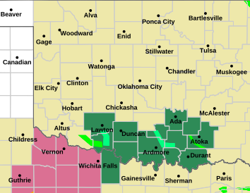
In map dark pink is for the storm watch and orange for heat advisory:


Those of you with home weather stations, do you have issues with the measurements being noticeably different than the Mesonet sites?
I realize having your home weather station is hyper-local and most of us aren't close to a Mesonet site, but it seems like my temperatures at home measure anywhere from 3-5° hotter than the closest Mesonet site, which could be anywhere from 10-15 miles away.
But then i look at a sampling of the area around my home from Weather Underground and they all seem somewhat similar to mine. So I'm not sure if comparing to the Mesonet is an apt comparison.


I am guessing that a lot of people with PWS's don't have their thermometers adequately shaded.


Official temperatures are always measured in the shade.


Yep. This is why when people post photos of their vehicle's ambient temperature, it is not even close to the actual air temp. A vehicle facing the sun parked on a blacktop for 3-4 hours can easily show the temp being 120F+. Obviously if it was actually 120 in OKC, it would be a much bigger story.
There are currently 24 users browsing this thread. (0 members and 24 guests)
Bookmarks