Widgets Magazine
Page 3 of 6 FirstFirst 123456 LastLast
Results 51 to 75 of 140

Thread: January and February 2020 - General Weather Discussion

  1. #51

    Default Re: January and February 2020 - General Weather Discussion

    Question asked to the U. S. National Weather Service, Norman OK on Facebook:

    Very disappointed that OKC didn't get any [snow] despite the hype. I know you all say it's difficult to track a weather system, but how do meteorologists do it up in the Northeast United States 5 days out???? I know because I lived there.

    ANSWER: It's much different trying to forecast winter weather in Oklahoma versus other parts of the country, partly because of the latitude, terrain, and proximity of the Gulf of Mexico. I'm one of the forecasters here, and came here from northeast Michigan many years ago. My first winter weather forecast here was a disaster. I still find it very difficult to deal with the mixture of weather types that occur here, instead of "just snow" farther north.

  2. #52

    Default Re: January and February 2020 - General Weather Discussion

    Cold front that has been draped across NW OK is now nudging into C OK. This will continue to slowly teeter back and forth with an eventual south movement.

    Storm approaching from the west Thursday evening into Friday will develop rain across the state, but temperatures for the majority of OK will be above 32F. So just a very cold rain for C OK, and some freezing rain across far NW OK, until eventual warm-air overrides the area. Thursday will be rainy and upper 30s for C OK.


  3. Default Re: January and February 2020 - General Weather Discussion

    Quote Originally Posted by Pete View Post
    This is my 4th winter since moving back and we haven't had more than a dusting that entire time.

    Seems like before I left in 1989, we had at least 2 good snowfalls every season.


    I don't miss the snow, but the pattern has certainly changed.
    We had one 3 to 4 inch snow last winter. I was at work at 4AM shoveling sidewalks just north of WRWA.

  4. #54

    Default Re: January and February 2020 - General Weather Discussion

    Ive got pictures of playing in the snow on January 3rd. Looks like it snowed several inches.

  5. #55

    Default Re: January and February 2020 - General Weather Discussion

    Quote Originally Posted by OKCretro View Post
    Ive got pictures of playing in the snow on January 3rd. Looks like it snowed several inches.
    I don't even remember anything close to that in NW OKC.

    I am wondering if this upcoming rain turns to ice or snow because it def. feels cold enough to get white stuff.

  6. #56

    Default Re: January and February 2020 - General Weather Discussion

    Here in C OK, temperatures are rising above freezing now and will continue heading into the evening. Far NW OK is really the only area expected to be at or below 32F for the majority of the precipitation.

  7. #57

    Default Re: January and February 2020 - General Weather Discussion

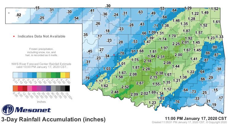
    This is a fantastic winter soaking for the central part of the state.

  8. #58

    Default Re: January and February 2020 - General Weather Discussion

    Quote Originally Posted by Anonymous. View Post
    This is a fantastic winter soaking for the central part of the state.
    Yep! Almost 2 inches at my house, since 6pm.

  9. #59

    Default Re: January and February 2020 - General Weather Discussion

    Right on. My house got 1.22". The midsection of Oklahoma, centered along the I-44 corridor, sure did get generous amounts of cold rain on Jan. 16 and 17. All three metros got over an inch. More rain is in the forecast later this month.


  10. #60

    Default Re: January and February 2020 - General Weather Discussion

    There will be a chance for quick moving rain turning to potentially heavy snow late Tuesday into Wednesday. If it does snow, it will be brief and not stick around too long as temperatures will be hovering right around freezing at the time. Best shots will be across N and NE OK.


  11. #61

    Default Re: January and February 2020 - General Weather Discussion

    The rain did change over to snow on the southside last night after midnight. Big, heavy, wet flakes, but zero accumulation. Was fun to see even if it was only for a little bit!

  12. #62

    Default Re: January and February 2020 - General Weather Discussion

    Watching this coming Tuesday for maybe a shot at a little clipper-type storm moving through. Cold air could be in place for winter precipitation. Will monitor.

  13. #63

    Default Re: January and February 2020 - General Weather Discussion

    Quote Originally Posted by Anonymous. View Post
    Watching this coming Tuesday for maybe a shot at a little clipper-type storm moving through. Cold air could be in place for winter precipitation. Will monitor.
    Not going to drop a ton of snow, right?

  14. #64

    Default Re: January and February 2020 - General Weather Discussion

    Quote Originally Posted by jdizzle View Post
    Not going to drop a ton of snow, right?
    Of course not, they are already trying to hype this as "possibly" some winter precipitation. I expect the metro to get nothing or next to nothing. What surprises me is that we haven't had any good solid artic fronts drop down and give us colder temps. January was warmer than normal and I expect Feb to do the same.

  15. #65

    Default Re: January and February 2020 - General Weather Discussion

    Quote Originally Posted by Achilleslastand View Post
    Of course not, they are already trying to hype this as "possibly" some winter precipitation. I expect the metro to get nothing or next to nothing. What surprises me is that we haven't had any good solid artic fronts drop down and give us colder temps. January was warmer than normal and I expect Feb to do the same.
    My tree is already flowering and it was covered in bees today!! WTH Oklahoma!! It’s January!!

  16. #66

    Default Re: January and February 2020 - General Weather Discussion

    Rain will develop late tonight into tomorrow morning across the area. At the same time, temperatures will gradually fall throughout the day as the low moves east into the plains.

    As of now, it looks like potential for snowfall will be on the north and west sides of the low. So the track will be important. Currently all models suggest snow chances will be best out across far NW OK and trailing off toward NC OK. Depending on the low's exact path, there are some very localized areas that could get under a heavy snowband, resulting in 4-7" amounts.

    In central OK - little to no impacts are anticipated from the snow, except where it may fall heavier for a short burst - allowing roads to become temporarily covered. The ground temperatures will be abnormally warm due to the mild weather we will experience on Monday.


  17. #67

    Default Re: January and February 2020 - General Weather Discussion

    From NOAA for NW OKC

    Tonight
    A slight chance of showers and thunderstorms, then showers and possibly a thunderstorm after midnight. Low around 38. East wind 8 to 16 mph, with gusts as high as 23 mph. Chance of precipitation is 90%. New rainfall amounts between a tenth and quarter of an inch, except higher amounts possible in thunderstorms.

    Tuesday
    Rain before noon, then rain and snow. High near 38. North wind 16 to 20 mph, with gusts as high as 28 mph. Chance of precipitation is 80%. New snow accumulation of less than a half inch possible.

    Tuesday Night
    Rain and snow likely before midnight. Cloudy, with a low around 27. North wind 11 to 16 mph, with gusts as high as 23 mph. Chance of precipitation is 60%. New snow accumulation of less than a half inch possible.

    https://forecast.weather.gov/MapClic...5#.Xi90oiVMHYU

  18. #68

    Default Re: January and February 2020 - General Weather Discussion

    Just a handful of degrees colder across the state and this would be a significant snow event. The track was perfect. A few counties in extreme NW OK got a decent amount.

  19. #69

    Default Re: January and February 2020 - General Weather Discussion

    Fantastic weekend on deck. Very mild and sunshine.

    Next storm action looks like maybe again Tuesday/Wednesday next week. More cold weather in the further outlook pipelines.

  20. #70

    Default Re: January and February 2020 - General Weather Discussion

    Going to go ahead and issue a Bread & Milk Watch for Tuesday into Wednesday. Ice and snow chances looking increasingly likely. At this time it does appear it could be a significant event.

  21. #71

    Default Re: January and February 2020 - General Weather Discussion

    Quote Originally Posted by Anonymous. View Post
    Fantastic weekend on deck. Very mild
    Mild? MILD?!? It's 80 M#$&!F'ing degrees.
    In February.

  22. #72

    Default Re: January and February 2020 - General Weather Discussion

    Quote Originally Posted by Edmond Hausfrau View Post
    Mild? MILD?!? It's 80 M#$&!F'ing degrees.
    In February.
    I remember I think back in February 2017 that KOKC hit 88 degrees. I believe that month as a whole finished about 7-8 degrees above average.

  23. #73

    Default Re: January and February 2020 - General Weather Discussion

    Quote Originally Posted by Edmond Hausfrau View Post
    Mild? MILD?!? It's 80 M#$&!F'ing degrees.
    In February.
    And now winter storm watch soon:

    Areas Affected:
    Caddo - Canadian - Carter - Cleveland - Comanche - Cotton - Garvin - Grady - Greer - Harmon - Jackson - Jefferson - Kingfisher - Kiowa - Lincoln - Logan - Love - McClain - Murray - Oklahoma - Payne - Pottawatomie - Seminole - Stephens - Tillman - Was hita

    Effective: Tue, 2/4 6:00pm Updated: Mon, 2/3 3:30am Urgency: Future
    Expires: Wed, 2/5 6:00pm Severity: Moderate Certainty: Possible

    Details:

    ...A WINTER STORM IS EXPECTED TO BRING SNOW INTO THE SOUTHERN
    PLAINS TUESDAY NIGHT AND WEDNESDAY...
    ...WINTER STORM WATCH IN EFFECT FROM TUESDAY EVENING THROUGH
    WEDNESDAY AFTERNOON...
    * WHAT...Heavy snow possible. Total snow accumulations of 4 to 6
    inches possible with locally higher amounts.
    * WHERE...All of western sections of north Texas, and that part of
    Oklahoma generally west of a line from Marietta to Ardmore to
    Davis to Seminole, and southeast of a line from Stillwater to
    Kingfisher to Cordell to Hollis.
    * WHEN...From Tuesday evening through Wednesday afternoon.
    * IMPACTS...Travel could be very difficult. The hazardous
    conditions could impact the morning or evening commute.
    * ADDITIONAL DETAILS...Continue to monitor the forecast for
    updated information as the storm system approaches.

  24. #74

    Default Re: January and February 2020 - General Weather Discussion

    Strong cold front blasts across OK tonight. Windchills overnight and into tomorrow morning will be very low.

    Storm begins to move into SW TX. As usual, the track is very important for who gets what. At this time, it appears the track of the low will be very favorable for producing heavy amount of snow and ice across OK.

    Tuesday highs will be just above freezing here in C OK with a healthy north wind. We should see some freezing drizzle and/or sleet/snow beginning around sundown. This will transition to full snow parameters as we head into the overnight hours. We should see 1-2 large areas of moderate to heavy snow form across TX and spread to the N/NE. Currently the track for heaviest snowbands appears to be across far NW TX and up along the I-44 corridor through OK. Amounts taper off the further NE. The track and evolution of the snowbands tomorrow night will be very important as the gradient to the NW of precipitation will be very sharp. W/NW OK could easily see little to zero snow. Because of this tight gradient, a shift slightly further south/east in the track will result in the heaviest snow totals being dragged to the SE. So here in central OK, there is bust potential as a result of a too far south track.

    At this time, OKC has a pretty good shot for say at least 5 inches. Once we get further into the window of some of the shorter-range forecast models, we can have more ways to pinpoint exact track.

    Winter Storm warnings will be issued either tonight or by early Tuesday morning.


  25. #75

    Default Re: January and February 2020 - General Weather Discussion

    As mentioned at the end of my last paragraph, here is a GFS run showing a track that is further SE, which would bust out C OK.


Thread Information

Users Browsing this Thread

There are currently 5 users browsing this thread. (0 members and 5 guests)

Similar Threads

  1. General Weather Discussion - February 2019
    By Anonymous. in forum Weather & Geosciences
    Replies: 118
    Last Post: 02-28-2019, 07:02 AM
  2. General Weather Discussion - January 2019
    By Bunty in forum Weather & Geosciences
    Replies: 108
    Last Post: 01-30-2019, 09:55 PM
  3. General Weather Discussion - January and February 2017
    By Anonymous. in forum Weather & Geosciences
    Replies: 263
    Last Post: 02-22-2017, 11:06 AM
  4. General Weather Discussion - January/February 2015
    By venture in forum Weather & Geosciences
    Replies: 525
    Last Post: 03-01-2015, 03:38 PM
  5. Oklahoma Weather Discussion - January/February 2012
    By venture in forum Weather & Geosciences
    Replies: 262
    Last Post: 02-29-2012, 08:04 AM

Bookmarks

Posting Permissions

  • You may not post new threads
  • You may not post replies
  • You may not post attachments
  • You may not edit your posts
  •  
Single Sign On provided by vBSSO