

Yes, the western half of the state basically is dry slotted. We could see redevelopment with the wrap-around energy, which could be significant. However, the most likely area for that to occur is across northern OK.

 Participating Member


Yes, the western half of the state basically is dry slotted. We could see redevelopment with the wrap-around energy, which could be significant. However, the most likely area for that to occur is across northern OK.
 Participating Member
Mike Morgan is forcasting severe weather for tomorrow afternoon for central up into northern Oklahoma. Hail to golf ball size and 70 mph winds possible.
So is Tuttle: A Rare Summer Severe Weather Event Tuesday: A Tornado Possible http://aarontuttleweather.com/2018/0...nado-possible/Originally Posted by Bobby821

[QUOTE=Sirsteve;1044503]The phenomenon sounds like the Stillwater split in which a very strong storm approaches Stillwater before missing Stillwater with no more than sprinkles, due to it splitting in two. It's most welcome to happen when the storm has a tornado in it.
Banned
Mike Morgan is a fearmongering ratings driving cash hoarding greedy good old boy sell out and I really wonder about his meteorological credentials. It’s a wonder he is still around but Oklahoma gonna Oklahoma I guess. Although according to the storm prediction center it looks like we have a marginal chance of storms so The threat can’t be taken with a grain of salt.
Participating Member
Short-range models are indicating storms developing across the area this evening, severe is possible, but it is not a not very high probabilities. These will be wrap-around spawned storms. If anything, I think damaging winds will be possible if a cluster can form across W/NW OK and push east in a bow-echo formation.

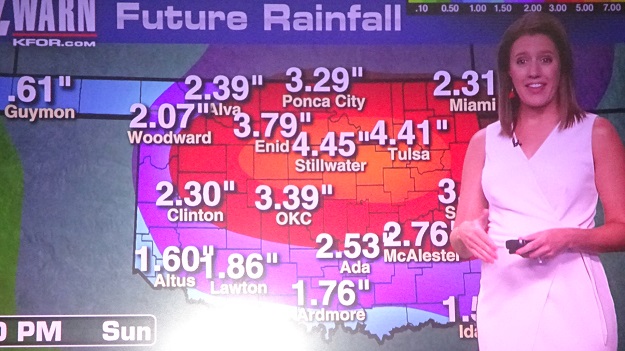
In addition to that, Emily added to the sensation that there won't be a Stillwater split during the period ending Sunday. Yeah, sure, lol. We'll see how the whole rain map turns out.
Banned
Ever since they came out with the 7 day plus 4 and the 5 plus 5 on Koco, its been wrong 90% of the time 2 days in their forecast. All they do is take what's off these other Weather websites and add their own spin to it. They cannot forecast better that 25% correct 1/2 the time. Just give us a 2-3 day forecast, and quit trying to sensationalize every damn thing. I would love for them to say we got this rain prediction wrong big time, sorry we Sucked at it again. I like David Payne says in his forecasts the Phrase, we've been telling y'all this since last week this next big weather pattern change is coming.. Shut up already.
Participating Member
MD is out for this evening:
Mesoscale Discussion 1287
NWS Storm Prediction Center Norman OK
0335 PM CDT Tue Aug 14 2018
Areas affected...Eastern Texas Panhandle...Western into Central
Oklahoma
Concerning...Severe potential...Watch unlikely
Valid 142035Z - 142300Z
Probability of Watch Issuance...20 percent
SUMMARY...Isolated severe thunderstorms possible over the next
several hours. Storms may produce isolated severe wind gusts in
addition to large hail. A WW issuance is currently not anticipated.
DISCUSSION...Scattered thunderstorms have recently developed in the
northeast Texas Panhandle into far northwest Oklahoma along a
boundary embedded within a broader zone of confluence. In addition,
a strong storm exhibiting transient supercell characteristics was
located along the McClain/Cleveland County Oklahoma border. These
storms are progressing across a moderately unstable airmass which
has recently undergone recovery from earlier precipitation via
strong surface heating. MLCAPE values of 2000-2500 J/Kg are common
across much of the discussion area, and recent TLX profiler data
suggests modest low-level directional shear (150 m2/s2 SRH) is
present. Still, with modest mid and low-level lapse rates (i.e 6
C/km), and negligible speed shear throughout the troposphere
characterizing the ambient atmosphere, any severe threat that occurs
is expected to be brief. The moderate instability environment
suggests that the more organized/long-lived updrafts may pose a
threat for large hail and gusty winds, though some brief instances
of low-level rotation may be observed with the strongest of storms
given the modest low-level directional shear.
Given the expected isolated nature of the severe threat, a WW
issuance is not expected at this time.
..Squitieri/Hart.. 08/14/2018
Participating Member
Models are continuing their focus on area of extended heavy rainfall somewhere across Central OK, just north of OKC.
Participating Member
Big time storm coming into/developing into the OKC metro. Already very localized flooding near the airport where a cell has been stationary for the last 2 hours.
The large cell coming in from the northwest will swallow up the WRA storm and add to the flooding. Storm has broad rotation so some small hail is not out of the question. But the real story is definitely going to be the heavy rainfall leading to flash flooding.
Participating Member
Here's to hoping the trenches I dug on Sunday actually help direct water away from house.
Participating Member
Rainfall from this event the last several days.

Unreal rainfall last night. My little electronic gauge tells me we got four inches in about four or five hours. And I think my gauge might be a bit conservative.
Participating Member
Checked the rain gauge this morning... Picked up just over 4½" of rain overnight at my house on the south side of the Metro, near I-240 and Santa Fe (4 miles due east of the airport). We had some fairly significant flooding... the water came all the way up my driveway to the garage door, but didn't get inside, thankfully.
Over 9" of rain in two weeks... in August. Pretty wild.
Participating Member
Looks like more severe storms and heavy rains are possible for Thursday, Friday, Saturday and Sunday. Should be fun!!
Banned
For?
Participating Member
For his sick, demented fetish.
Participating Member
Cute.
Honestly, relax. There's nothing wrong with enjoying thunderstorms. I quite enjoy them myself!
Participating Member
I enjoy average thunderstorms. My pocketbook doesn't enjoy severe thunderstorms. I certainly don't take great delight in extreme, destructive severe storms that the aforementioned eagerly looks forward to and cheers on.
Platinum Member
He goes way beyond enjoying thunderstorms. He roots for severe weather. That's why many of us have blocked him. Unfortunately, I see him when he is quoted. As someone who has suffered tragic losses from severe weather I find his sick fetish deeply offensive.
Participating Member
Probabilities are low, but worth mentioning. Thursday evening into Friday we could see some storms develop in the NW and push SE. Location and timing is difficult to pinpoint at this time, and development may not even occur at all.
The same rain/storm chances holds true for Friday night through Saturday. Random development and unorganized behavior of storms is a possibility, but a low one.
Higher rain chances into Sunday, but still nothing looking too organized. Best shot will be in NE/E OK.
Temperatures rise back into the 90s next week as we dry out some. Then perhaps another wet/mild pattern coming back as we head into the weekend around the 24th.
Participating Member
I know long term outlooks are always fickle, but does it look like we may have weathered the hottest part of the summer already?
Participating Member
I would venture out to say for OKC, that is likely true. W and SW OK could easily see more 100s. Moisture in the ground and in vegetation means more moisture in the air around it. The recent rainfall we have had will likely put a stop on the "extreme" temperatures for most of the state.
We still need our neighbors in W OK, through the TX panhandle, and out west toward the 4 corners to get moisture. This will help storm systems retain strength and moisture as they come into the plains.
I feel like that part of the country is perpetually in some state of drought. Every year it’s the same story.
There are currently 9 users browsing this thread. (0 members and 9 guests)
 Posting Permissions

 Reply With Quote

Bookmarks