So time to start another month of weather. It's January. Happy New Year 2018.
So time to start another month of weather. It's January. Happy New Year 2018.


Highs in the low 50s this weekend, but rain will move in late Saturday night into Sunday morning. Looks like potentially measurable rainfall from about I-35 and to the east.


Highs back into the 60s for Tuesday and Wednesday. Storm system comes through Wed night, at this time, looks like maybe some dry snow showers on Thursday with temperatures plummeting back into the 30s heading into the weekend.
Looks like this could be a major winterstorm across the Ohio/Mississippi valley.
All of OK is now in some type of drought category.
Something to keep an eye on this was posted by NWS Norman in there afternoon forecast:
For late Sunday into Tuesday southerly flow is forecast to develop over the cold surface airmass. This may lead to significant amounts of freezing rain if everything comes together as currently forecast by the operational GFS and ECMWF. However, model guidance that far
out is not usually very reliable, and ensemble forecasts for that
time period clearly show a lot of variability.
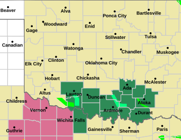
WIND ADVISORY
Areas Affected:
Atoka - Bryan - Caddo - Canadian - Carter - Cleveland - Coal - Comanche - Cotton - Garfield - Garvin - Grady - Grant - Hughes - Jefferson - Johnston - Kay - Kingfisher - Lincoln - Logan - Love - Marshall - McClain - Murray - Noble - Oklahoma - Payne - Pontotoc - Pottawatomie - Seminole - Stephens - Tillman
Effective: Thu, 1/11 6:00am Updated: Wed, 1/10 3:53pm Urgency: Expected
Expires: Thu, 1/11 9:00pm Severity: Minor Certainty: Likely
Details:
...WIND ADVISORY IN EFFECT FROM 6 AM TO 9 PM CST THURSDAY...
The National Weather Service in Norman has issued a Wind
Advisory, which is in effect from 6 AM to 9 PM CST Thursday.
* TIMING...Thursday morning through early evening.
* WINDS...Sustained 25 to 35 mph with gusts up to around 50 mph
possible.
* IMPACTS...Strong winds could cause loose, outdoor items to move.
* OTHER IMPACTS...Strong winds combined with cold temperatures
will lead to cold wind chills.
Information:
A Wind Advisory means that winds of 35 mph are expected. Winds
this strong can make driving difficult, especially for high
profile vehicles. Use extra caution.
Area in brown covered:


A small cluster of showers/thunderstorms will develop over NW TX and into SW OK and sweep NNE across the state and slowly dissipate. After that, our strong southerly winds shift to strong northerly winds and the cold air rushes into the state.
Cold and extremely windy as the low pressure system will be directly over northern OK in the morning. As we head into the afternoon, a chance of a narrow band of light to moderate snow will be possible somewhere across C into E OK. Best chance of seeing this band is directly east of OKC and going north up toward Tulsa. Impacts should be none to minimal.
After this storm we turn our attention toward any moisture that wants to sneak up across a shallow cold air pool that may or may not stick around. Models cannot decide on either.


That wind is blowing this morning!
Is it supposed to slow down at any point today? I need to go out and get my run in today, but if there is a time where I wouldn't be running against this wind it would be a lot nicer.


The wind will pretty much be constant. Slowdown well after dark when it is around 20F, if you prefer that.


Cold front just blasted through the state. Temperatures will drop all day. Lows tomorrow morning will be around 10F. We should get back above freezing by Thursday as strong southerly winds return ahead of a storm system.
Next precip chances look to be this coming weekend, perhaps some strong storms possible as temperatures could climb to near 70F ahead of the action.


Got very cold last night....my pipes froze.
This one of the longer and deeper cold snaps I can remember, especially since last year was so incredibly mild.
Looks like one pretty cold day tomorrow then back into the 50's.


^^^ And wheat bugs too -


Our temperature rebound begins now! Highs in the mid and upper 60s come this Saturday.
The storm system that looked like it could impact OK as been shifting forecast more north, so impacts are decreasing. Extreme eastern OK may still get some storm action.
Looking ahead, the next chance of storm precipitation is around the 27th.
FIRE WEATHER WATCH
Areas Affected:
Alfalfa - Beckham - Blaine - Caddo - Canadian - Carter - Cleveland - Comanche - Cotton - Custer - Dewey - Ellis - Garfield - Garvin - Grady - Grant - Greer - Harmon - Harper - Jackson - Jefferson - Kay - Kingfisher - Kiowa - Lincoln - Logan - Love - Major - McClain - Murray - Noble - Oklahoma - Payne - Pottawatomie - Roger Mills - Stephens - Tillman - Wa****a - Woods - Woodward
Effective: Sun, 1/21 11:00am Updated: Fri, 1/19 3:01pm Urgency: Future
Expires: Sun, 1/21 9:00pm Severity: Moderate Certainty: Possible
Details:
...Critical to Extreme Fire Danger on Sunday across mainly the
western half of Oklahoma and western north Texas...
.The combination of strong gusty winds, warm and dry conditions,
dry vegetation, and a strong storm system moving across the
southern Plains will likely cause critical to extreme wildfire
danger on Sunday.
...FIRE WEATHER WATCH IN EFFECT FROM SUNDAY MORNING THROUGH
SUNDAY EVENING FOR WINDY CONDITIONS... WARM TEMPERATURES AND LOW
RELATIVE HUMIDITY FOR MAINLY THE WESTERN HALF OF OKLAHOMA AND ALL
OF WESTERN NORTH TEXAS...
The National Weather Service in Norman has issued a Fire Weather
Watch for windy conditions, warm temperatures, and low relative
humidity, which is in effect from Sunday morning through Sunday
evening across mainly the western half of Oklahoma and all of
western north Texas.
* WINDS...Southwest 20 to 35 mph with gusts 30 to 50 mph. The
strongest wind gusts are expected across western Oklahoma Sunday
afternoon. A cold front will bring a wind shift to the northwest
late Sunday afternoon into the evening.
* RELATIVE HUMIDITY...10 to 30 percent.
* TEMPERATURE...Highs 55 to 70 degrees F.
* IMPACTS...Fires that develop will likely spread rapidly.
Outdoor burning is not recommended.
Information:
A Fire Weather Watch means that critical fire weather conditions
are forecast to occur. Listen for later forecasts and possible
Red Flag Warnings.
Counties covered

Crazy to see a Tornado Watch for the far eastern OK counties. Temps in that area are in the low 70’s with an almost 60 degree dewpoint.
I realize this isn't directly part of OK weather, but I was saddened to read a tweet from Reed Timmer that his old chasing buddy from the Storm Chasers series, Joel Taylor, passed away at the age of 38. Waay too stinking young. No cause released or mentioned at this point.
https://heavy.com/news/2018/01/joel-...h-how-did-die/


Such a sad situation. I never met Joel personally, but he was very respected in the storm chasing groups.
Some speculation is out on cause, and it seems to be pointing toward [accidental] drug OD/combination where he was at a concert on a cruise ship.


Critical fire danger for pretty much every day until it rains something. It is getting bad out there. Western OK is basically ready to all go up any moment.

It's been issued for the majority of the state:
RED FLAG WARNING
Areas Affected:
Alfalfa - Beckham - Blaine - Caddo - Canadian - Cleveland - Comanche - Custer - Dewey - Ellis - Garfield - Grady - Grant - Greer - Harmon - Harper - Jackson - Kay - Kingfisher - Kiowa - Lincoln - Logan - Major - McClain - Noble - Oklahoma - Payne - Roger Mills - Tillman - Was hita - Woods - Woodward
Effective: Thu, 1/25 12:00pm Updated: Thu, 1/25 2:05pm Urgency: Expected
Expires: Thu, 1/25 7:00pm Severity: Severe Certainty: Likely
Details:
...CRITICAL FIRE WEATHER CONDITIONS POSSIBLE THURSDAY...
...RED FLAG WARNING IN EFFECT FROM NOON TODAY TO 7 PM CST THIS
EVENING FOR BREEZY WINDS AND LOW RELATIVE HUMIDITY FOR MUCH OF
NORTHERN, CENTRAL AND WESTERN OKLAHOMA AND WESTERN NORTH TEXAS...
The National Weather Service in Norman has issued a Red Flag
Warning for breezy winds and low relative humidity, which is in
effect from noon today to 7 PM CST this evening. This replaces
the Fire Weather Watch which is no longer in effect.
* TIMING...Thursday afternoon into early evening.
* WINDS...South 15 to 25 mph with gusts up to 35 mph.
* RELATIVE HUMIDITY...As low as 12 to 20 percent.
* TEMPERATURES...Highs in the mid to upper 60s.
* IMPACTS...Any fires that develop will likely spread rapidly.
Outdoor burning is not recommended.
Information:
A Red Flag Warning means that critical fire weather conditions
are either occurring now, or will shortly. A combination of
strong winds, low relative humidity, and warm temperatures can
contribute to extreme fire behavior.
Counties in Red Covered:


Governor's Burn Ban now in effect for essentially all counties along I-35 and west. 40 counties in all.
http://www.forestry.ok.gov/burn-ban-info
Valid to 16 February 2018.
Is a February polar vortex in the making? If so, I wonder if much snow comes with it? https://www.freightwaves.com/news/20...ns-in-february


An outside shot @ precipitation this weekend, but does not look promising for anyone, except maybe extreme SE OK.
Looking ahead, the weather appears to remain bone-dry. Unless something changes, this is going to go down as one of the driest winter's in southern plains history. It is already bad in a swath from KS/OK/TX/NM and it will be getting worse.
There are currently 2 users browsing this thread. (0 members and 2 guests)
Bookmarks