

Short range models keeping discrete supercells developing down in SW OK and moving toward C OK this evening. Then entire line lights up and consumes these cells. Hail threat will be significant with these early storms.


 Participating Member


Short range models keeping discrete supercells developing down in SW OK and moving toward C OK this evening. Then entire line lights up and consumes these cells. Hail threat will be significant with these early storms.
Participating Member
Latest data shows 1-2 supercells firing somewhere near Caddo county. Tornado watch is coming soon.
Tornado watch for OKC until 10 pm.
Counties covered:

Participating Member
Huge hail coming out of that first supercell heading to west of Carnegie. Also rotation is becoming more organized (hence the hail size).
Participating Member
All storms now severe. Most dangerous storms are from Carnegie to Cordell.
The line is now forming out along the TX/OK border and will race east. This line will engulf the storms ahead of it and create a widespread damaging wind scenario for C OK.
In Stillwater, was that thunder or an earthquake? An any rate, a narrow new line of storms is approaching Stillwater as of 5:15 pm. No advisories for there at that time.

Participating Member
Reports of tornado on storm west of Cache.
Participating Member
Tornado headed into Medicine Park. Western sides of the town.
Participating Member
Tornado threat quickly diminishing as cluster moves closer to C OK.
Anon, that storm with the rotation down near Cyril and heading toward Chickasha - you think that rotation becomes less intense as it approaches OKC? Starting to get close enough to....well, pay attention a bit.Originally Posted by Anonymous.

It didn't diminish quickly enough to keep a EF-1 tornado from hitting the Riverwind Casino in Norman where the governor was present for the Beach Boys concert.
Participating Member
Yea I was gone after that post so didn't update. But yea that one storm's hook just rode along the line straight into the Norman area. Quick little spinup.
Participating Member
Lows Saturday morning:

FREEZE WATCH
Areas Affected:
Alfalfa - Atoka - Beckham - Blaine - Caddo - Canadian - Carter - Cleveland - Coal - Comanche - Cotton - Custer - Dewey - Garfield - Garvin - Grady - Grant - Greer - Harmon - Hughes - Jackson - Jefferson - Johnston - Kay - Kingfisher - Kiowa - Lincoln - Logan - Love - Major - McClain - Murray - Noble - Oklahoma - Payne - Pontotoc - Pottawatomie - Roger Mills - Seminole - Stephens - Tillman - Wash ita
Effective: Sat, 10/28 12:00am Updated: Wed, 10/25 7:00pm Urgency: Future
Expires: Sat, 10/28 10:00am Severity: Moderate - Certainty: Possible
Details:
...FREEZE WATCH IN EFFECT FROM LATE FRIDAY NIGHT THROUGH SATURDAY
MORNING...
The National Weather Service in Norman has issued a Freeze Watch,
which is in effect from late Friday night through Saturday
morning.
* TEMPERATURE...29 to 32 degrees across much of the area, possibly
as low as 24 degrees across northwest Oklahoma.
* IMPACTS...Sensitive plants may be damaged or killed if left
outdoors unprotected. A hard freeze is likely across northwest
Oklahoma Saturday morning.
Information:
A Freeze Watch means sub-freezing temperatures are possible.
These conditions could kill crops and other sensitive vegetation.
COUNTIES AFFECTED:
Participating Member
Coldfront just came through OKC. Strong northerly winds will be arriving as we head into the evening hours. Winter jacket weather the next two days.
Gold Member
Thank you cold front. Please let me yard die a quick death
Banned
Dat wind, tho! Shaking my whole apartment building!
Gold Member
Yes, mine too!
Participating Member
Unfortunately for the kids, looks like Halloween will be the worst weather day this week. Cold & cloudy with a slight chance of some light showers towards evening.
After that, we warm up significantly for Wednesday and Thursday. Fire danger will be high. Then another cooldown comes in for Friday. For the moment, this weekend looks fantastic.
Participating Member
Beautiful day today, try to hold off on turning on the AC - because tonight is another cooldown. Friday highs will be in the 50s. Saturday we warm back up to 70s, and Sunday most of the state will be back in the 80s.
Looking ahead, next week cools down significantly with a chance of rain coming mid-week. Look for highs in the 40s in the latter part of the week until finally moderating into the weekend with some highs in the 60s.
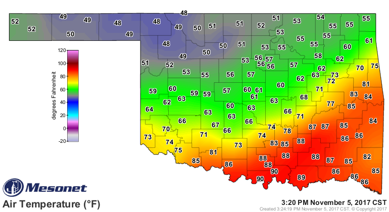
A glaring temperature contrast from 48 to 90 in Oklahoma on Sunday afternoon while a cold front makes another attempt to pass through the state.
 Owner / Administrator

Holy cow, all week the forecast was for 80 in OKC and now it's barely in the 60's.
Participating Member
^ Yes, the boundary sagged about 30 miles further south than forecast. So the highs were made around 10am.
This cold air is going to sit over the plains for a while. Cold rain chances move in Tuesday night into Wednesday. Likely a freeze Wednesday night, especially if skies clear. Moderation still looks likely as we head towards the weekend with highs getting back into the 60s.
Participating Member
Fog and drizzle will develop overnight tonight.
High fire danger coming Friday. Weekend looks pleasant with highs in the low 60s.
WIND ADVISORY
Areas Affected:
Alfalfa - Atoka - Beckham - Blaine - Bryan - Caddo - Canadian - Carter - Cleveland - Coal - Comanche - Cotton - Custer - Dewey - Ellis - Garfield - Garvin - Grady - Grant - Greer - Harmon - Harper - Hughes - Jackson - Jefferson - Johnston - Kay - Kingfisher - Kiowa - Lincoln - Logan - Love - Major - Marshall - McClain - Murray - Noble - Oklahoma - Payne - Pontotoc - Pottawatomie - Roger Mills - Seminole - Stephens - Tillman - Wash ita - Woods - Woodward
Effective: Sat, 11/18 12:00am Updated: Fri, 11/17 5:12am Urgency: Expected
Expires: Sat, 11/18 3:00pm Severity: Minor Certainty: Likely
Details:
...WIND ADVISORY IN EFFECT FROM MIDNIGHT TONIGHT TO 3 PM CST
SATURDAY...
The National Weather Service in Norman has issued a Wind
Advisory, which is in effect from midnight tonight to 3 PM CST
Saturday.
* TIMING...Late tonight through Saturday afternoon.
* WINDS...North 25 to 30 mph sustained with gusts over 50 mph,
especially western and northern Oklahoma.
* IMPACTS...Driving on east-west roadways may be difficult for high-
profile vehicles.
Information:
A Wind Advisory means that winds of 35 mph are expected. Winds
this strong can make driving difficult, especially for high
profile vehicles. Use extra caution.
Light brown area affected:
There are currently 3 users browsing this thread. (0 members and 3 guests)
 Posting Permissions

 Reply With Quote
Bookmarks