

Is this whole trail already opened? How do I put it into Google maps? This is the route I could actually take to work which would be much safer than what I'm doing....

 Participating Member

Is this whole trail already opened? How do I put it into Google maps? This is the route I could actually take to work which would be much safer than what I'm doing....
Participating Member

It isn't officially open, and there are still seemingly random sections that aren't paved yet (for example, part of NW Expy between NW 63rd and Portland, and I believe Meridian between NW Expy and NW 63rd), but it may work for you depending on where you're going.Originally Posted by AP

Participating Member
The path is complete (except for some residual landscaping) from the bridge over the storm drain on NW Expy between Portland and 63rd west to the condos about 3 blocks east of Meridian. From there the initial asphalt is down but many of the curb cuts are unfinished, including the ones at 63rd and Meridian. No paving from there north to NW Expy, just some of the driveway rebuilds.
Participating Member
OKC officials: Trail money unlikely to support new businesses
By: Brian Brus The Journal Record October 16, 2017
OKLAHOMA CITY – Millions of dollars in MAPS 3 funds to create walking trail links across the city is unlikely to produce much business along the route, city officials said.
Residents have tended to operate in one of two modes with little crossover when it comes to attractive outdoor spaces: active lifestyle or restaurants. But that’s changing, said Susan Hooper, chairwoman of the MAPS 3 Citizens Advisory Board Trails and Sidewalk Subcommittee.
“I think we can be both. I think we’re striving for both,” she said. “But I do think we have to be very conscientious about moving forward and making a plan for what the development might be.”
Several years ago, city leaders responded to constituents’ demands for more park space and healthy lifestyle options by including trail projects, river district improvements and new sidewalks as part of the $777 million MAPS 3 ballot issue. Those projects were approved by voters in 2010.
Work is scheduled to begin soon on a 9-mile stretch of walking trails referred to as the Will Rogers connection. That trail will link the Oklahoma River trail at May Avenue to Lake Hefner at Meridian Avenue. The work will cost about $9.7 million. Hooper’s group is scheduled to review the project phases at a meeting Oct. 25.
David Todd, the city’s MAPS project manager, said one more major trails project at Lake Draper is due to be bid at the end of this year. That trail is 13 miles.
Board member Hal McKnight said he has a strong passion to expand the city’s trail system, but he’s got to hold business development at a distance, at least for now. A healthier lifestyle for the city overall is its own reward, he said, which will generate other benefits as a consequence. If that proves to be coffee shops along the trail, it will be largely market-driven.
“From a commercial standpoint, it’s one of the gems of why businesses would want to locate in Oklahoma City, our renewed statement of wellness,” McKnight said. “It’s one thing if you create all this stuff and there’s no impact.
“But we’re seeing an incredible impact on the lives of our citizens and people who are coming from a farther distance to visit those trails.”
McKnight also pointed to lessons learned from the eastern side of Lake Hefner. Almost 15 years ago, council members agreed to allow zoning for a few restaurants balanced against public outcry for spoiling the scenery. The east side of the lake now has four restaurants near the marina.
Hooper said her group was created for the purpose of overseeing MAPS 3 money use to meet the public’s expectations. Supporting business development is a different matter, but that doesn’t mean it won’t crop up in discussions someday and lead to new tasks.
“We’re very careful about not overstepping our job,” she said.
Participating Member
I rode this trail from NW 36th to the Reno yesterday. It's a Godsend for me, as I was using Villa and that is way more dangerous than this separated lane. I very much enjoyed the smooth ride.
 Owner / Administrator

Is everything pretty much done now for that section?
I know the path along NW Expressway is moving along now.
Participating Member
There are a couple of sections that have a little detail to be finished, like the edges of the trail need trimmed and capped in some areas. It is definitely usable now, though. I think the connection at 10th north of the Fairgrounds needs to be complete, but the trail is finished on both sides. The crossing at 23rd is hairy, but that's because they are working on the bridge there.
Owner / Administrator
Regarding the fairgrounds, I think it's more fun to cut through the grounds anyway.
You can ride through the main gate and south and then pick up the road that leads out to May, where you can jump back on the trail.
Wonder if they have finished the connection from the south end of the trail to the river trail?
Platinum Member
Yes Pete that connection is in place.
I rode most of the trail this weekend. My take is this: this trail makes possible a route that would otherwise be impossible, But it is not a fun ride. Even though you are on a seperated route you are still right next to traffic and the loud interstate and there are many many street and driveway crossings. It is not calming or scenic. In more than one place I crossed broken glass which is hazardous for bike tires (which is surprising for such a new trail).
Nonetheless I welcome the trail, as it adds a ton more flexibility to the River trail network, and should be good for commuters and those living along its route. But don't expect anything like the Katy Trail or West River Trail where you are really away from things.
Owner / Administrator
I agree that there is a ton of traffic noise from the Interstate for most of it and many, many places where you have to cross traffic and be on hihg alert.
However, it does serve to make bike travel in that area possible and also closes a big loop between the river, Lake Overholser and Lake Hefner.
Platinum Member
I agree. The ride might not be pleasant, but it is at least possible. Before construction of this Trail riding a bike on this route was almost literally impossible.
Participating Member
The ride is 1000% more pleasant than riding in the street.
Participating Member
They have just laid asphalt north from 63rd to NW Expressway. That means (except for some of the curb cuts and finishing landscaping), it is essentially completed from NW 39th to Lake Hefner Park.
Participating Member
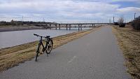
Finally rode the trail today and took some pics for anyone who is interested. Besides landscaping, it was complete everywhere except Meridian between NW 63rd and NW Expwy, the crossing from NW Expwy onto Portland, and at NW 23rd (where there's a bunch of construction regardless). I do have to agree that it wasn't exactly a serene ride with the number of busy intersections one has to cross and the industrial nature of the southern half (plus the stray dog I dealt with south of Will Rogers Park, lol), but it definitely fills a major gap and will hopefully be utilized by folks who need it. I was also really glad to see the solar-powered lights between NW 50th and NW 39th. Very nice.
Just east of the Integris complex:
Just south of NW 50th:
Will Rogers Park:
Protected in-road lane south of NW 16th:
Junction with the Oklahoma River trail:
Participating Member
What kind of bike do you have? I'm digging it.
Owner / Administrator
Thanks for the photos! I need to get out there and try it again.
I want to ride all the way from Will Rogers to the river then around Overholser up and around Hefner and then back down again.
Participating Member
Thanks! It is a Giant Escape City from a few years ago (2012?). It was recommended to be as a hybrid bike for commuting when I lived in Norman that could handle bumps and grass a bit better than a road bike. In hindsight for these longer rides I wish I had something that was lighter and closer to a road bike, but it has served me well so far.
Participating Member
Diggin the solar lights! We need more of those along trails and sidewalks in the city.
Participating Member
I drove down Expressway today and noticed they are putting cable barriers to the north of the bike lanes along Expressway. Now, not all the way along, mind you, but the areas that are closer to the road. I didn't know that was part of it, but I am glad it is.
Participating Member
If I plan on visiting in January and bringing my bike, will this trail take me all the way from Bricktown to the Lake Hefner loop? I'd love to give these new trails a ride since I moved away.
Participating Member
Lol. I’m going to do it with a Spokies bike after Christmas.
Participating Member
That's going to be expensive.
Participating Member
Hmmm. I’ll have to figure out the exact costs.
Participating Member
Yes. You would have to go along the river and then north. By January, you should be good.
Participating Member
I'm pretty sure it's $3 initial cost plus $3 every thirty minutes unless you check it back in before the half hour ends. I don't think you'll find any Spokies stations out that far, but I haven't looked at their station map in a while.
There are currently 2 users browsing this thread. (0 members and 2 guests)
 Posting Permissions

 Reply With Quote
Bookmarks