


This article will be updated over time to include a catalog of various definitions of terms, descriptions of events or processes, and a general overall resource to refer to. Essentially this is going to be the FAQ of the weather section. If you have contributions or questions, please comment on the article and I'll get it added. We'll get this stickied so it remains on top like the severe weather archive.
Reporting Severe Weather
If you experience any severe weather (see definitions below) please by submitting a storm report! There are various ways to send in information:
- NWS Norman Online Storm Report Form
- NWS Tulsa Online Storm Report Form
- Spotter Network
- Amateur Radio
- NSSL mPING Mobile App
Definitions
Term Related Terms Definition PDS Particularly Dangerous Situation is a type of watch where the risk of high end severe weather is possible. PDS Severe Thunderstorm Watch PDS Blue Box Typically issued for a widespread severe wind event, called a derecho. PDS Tornado Warning Issued when a large tornado is confirmed to be producing damaging. PDS Tornado Watch PDS Red Box Potential for multiple strong or violent tornadoes in the watch box area. Severe Thunderstorm Winds equal to or over 58 mph and hail over 1 inch in diameter. Severe Thunderstorm Watch Blue Box Conditions favorable for severe thunderstorms. Also called a "blue box". Significant Weather Advisory A strong thunderstorm that is radar indicated in an area just below severe limits. It will be issued using the "Special Weather Statement" product from the NWS. Tornado Emergency Highest end tornado warning issued when violent tornado is moving through populated area. Tornado Watch Red Box Conditions favorable for severe thunderstorms and tornadoes. Also called a "red box"
SPC Severe Weather Outlooks
Source: http://www.spc.noaa.gov/misc/SPC_probotlk_info.html
Marginal Risk (dark green)
A MRGL risk area implies severe storm of limited organization and longevity or very low coverage and marginal intensity.
Slight Risk (yellow)
A SLGT risk implies organized severe thunderstorms are expected, but usually in low coverage with varying levels of intensity.
Enhanced Risk (orange)
An ENH risk implies greater concentration of organized severe thunderstorms with varying levels of intensity.
Moderate Risk (red)
A MDT risk implies potential for widespread severe weather with several tornadoes and/or numerous severe thunderstorms, some of which may be intense.
High Risk (magenta)
The HIGH risk suggestions a severe weather outbreak is expected from either numerous intensive and long-track tornadoes, or a long-lived derech system with hurricane-force wind gusts producing widespread damage.
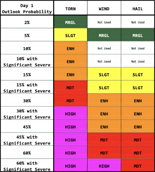
Probability Conversion Tables
- Probabilities are calculated as meaning a person has a X% chance of that severe event occurring within 25 miles of the location.
- Hatched areas represent a 10% or greater probability for significant severe events to occur within 25 miles of the location.
- Significant event is a tornado EF2 or higher, damaging winds 74 mph or higher, and hail at least 2 inches in diameter.


 Reply With Quote
Bookmarks