Widgets Magazine
Page 1 of 4 1234 LastLast
Results 1 to 25 of 86

Thread: Severe Weather Discussion - August 10 through ??

Hybrid View

Previous Post Previous Post   Next Post Next Post
  1. Default Severe Weather Discussion - August 10 through ??

    Risk of isolated severe as we transition in an out of the NW flow pattern for awhile here. Won't put any specific end date on this.


    URGENT - IMMEDIATE BROADCAST REQUESTED
    SEVERE THUNDERSTORM WATCH NUMBER 697
    NWS STORM PREDICTION CENTER NORMAN OK
    435 PM CDT MON AUG 10 2009

    THE NWS STORM PREDICTION CENTER HAS ISSUED A
    SEVERE THUNDERSTORM WATCH FOR PORTIONS OF

    NORTHWEST ARKANSAS
    NORTH-CENTRAL AND NORTHEAST OKLAHOMA

    EFFECTIVE THIS MONDAY AFTERNOON AND EVENING FROM 435 PM UNTIL
    1000 PM CDT.

    SCATTERED DAMAGING WINDS
    ISOLATED WIND GUSTS TO 80 MPH POSSIBLE
    WIDELY SCATTERED LARGE HAIL TO 1.5 INCHES IN DIAMETER

    THE SEVERE THUNDERSTORM WATCH AREA IS APPROXIMATELY ALONG AND 50
    STATUTE MILES NORTH AND SOUTH OF A LINE FROM 25 MILES SOUTH
    SOUTHWEST OF PONCA CITY OKLAHOMA TO 30 MILES EAST OF FAYETTEVILLE
    ARKANSAS. FOR A COMPLETE DEPICTION OF THE WATCH SEE THE
    ASSOCIATED WATCH OUTLINE UPDATE (WOUS64 KWNS WOU7).

    REMEMBER...A SEVERE THUNDERSTORM WATCH MEANS CONDITIONS ARE
    FAVORABLE FOR SEVERE THUNDERSTORMS IN AND CLOSE TO THE WATCH
    AREA. PERSONS IN THESE AREAS SHOULD BE ON THE LOOKOUT FOR
    THREATENING WEATHER CONDITIONS AND LISTEN FOR LATER STATEMENTS
    AND POSSIBLE WARNINGS. SEVERE THUNDERSTORMS CAN AND OCCASIONALLY
    DO PRODUCE TORNADOES.

    OTHER WATCH INFORMATION...CONTINUE...WW 694...WW 695...WW 696...

    DISCUSSION...VERY UNSTABLE AIRMASS AHEAD OF SURFACE OUTFLOW
    BOUNDARY/COLD FRONT PUSHING INTO NRN OK LATE TODAY IS ALREADY
    FUELING SEVERE THUNDERSTORM DEVELOPMENT OVER THE REGION. STEEP LOW
    LEVEL LAPSE RATES AND LARGE DOWNDRAFT-CAPE SHOULD ENHANCE CONVECTIVE
    DOWNBURSTS...WITH 20-30 KT WLY EFFECTIVE SHEAR SUPPORTING SOME
    ORGANIZATION INTO LINES OR SLOW MOVING CLUSTERS. WIND DAMAGE WILL
    BE PRIMARY THREAT...ALTHOUGH ISOLATED LARGE HAIL AND HEAVY RAINFALL
    WILL BE ADDITIONAL HAZARDS THROUGH MUCH OF THE EVENING.

    AVIATION...A FEW SEVERE THUNDERSTORMS WITH HAIL SURFACE AND ALOFT
    TO 1.5 INCHES. EXTREME TURBULENCE AND SURFACE WIND GUSTS TO 70
    KNOTS. A FEW CUMULONIMBI WITH MAXIMUM TOPS TO 500. MEAN STORM
    MOTION VECTOR 28015.

  2. Default Re: Severe Weather Discussion - August 10 through ??


  3. Default Re: Severe Weather Discussion - August 10 through ??

    Oklahoma is quite lucky this year.

  4. Default Re: Severe Weather Discussion - August 10 through ??

    I am in absolute disbelief about this.. we are having a swimming pool installed.. and of course, every rain drop sets up back a week. ugh. I'm so bummed. On the upside, I like the cooler weather, like the rain for our crops and state but on the other hand, I just can't fathom why the one year we decided to do major landscaping project, it practically rains all summer long. Well, it could be worse.. I'm just an impatient person.
    " You've Been Thunder Struck ! "

  5. #5

    Default Re: Severe Weather Discussion - August 10 through ??

    Karried,

    Better a litttle rain for the crops and the landscaping instead of a drought. Have you see what has happened with the lakes in southern most Texas? It is just horrific down that way.

    Let us know when the pool is ready...I smell a pool party for OKCTalk!! :-)

  6. Default Re: Severe Weather Discussion - August 10 through ??

    Karrie /hugs. I know how you feel. LOL

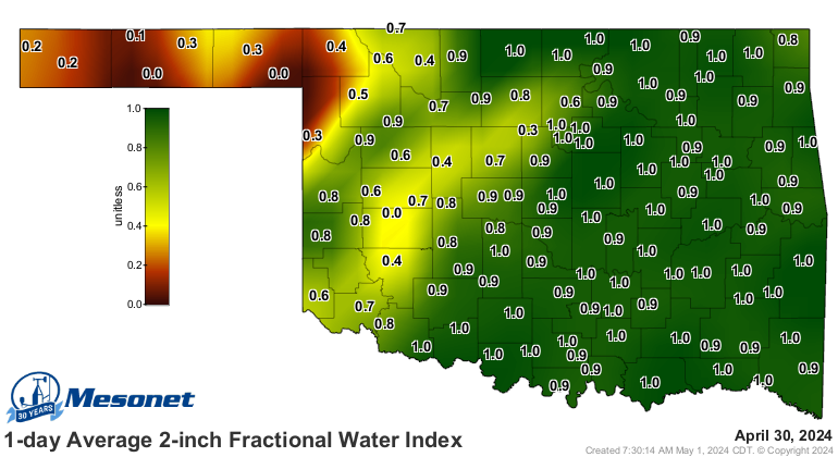
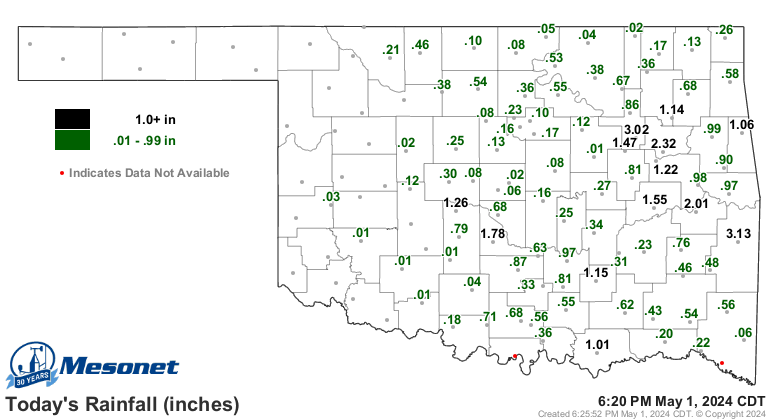
    On the need for water though...some definite good news today. First graphic is the ground water index and how much moisture is in the top several inches. The second graphic is the rain in the last 24 hours. The areas in the most need seem to be lining up pretty well with those getting raid today.


  7. Default Re: Severe Weather Discussion - August 10 through ??

    Next line of storms continues to intensify as it moves into the Metro. Hail will be minimal it seems right now, unless a few cells get some good development going. Strong winds main threat and lightning. Outflow boundary is ahead of the line anywhere from 1-2 miles to as many as 10 miles - just depending on where you are. Gusts to 50 mph are easily doable right now.

  8. Default Re: Severe Weather Discussion - August 10 through ??


    Slight risk today is north of a line from just south of Erick to Hobart to Anadarko to Norman to Shawnee to Henryetta to north of Sallisaw.

    Some gusty winds and hail are the severe threats. Main threat though is going to be extremely heavy, flooding rain in areas where storms will train or stall. Flash flood watch is now up for areas of Oklahoma North of I-40 and along and west of I-35...including the Northern half of the OKC metro area (Cleveland/McClain/Pott aren't included).

  9. Default Re: Severe Weather Discussion - August 10 through ??


    MESOSCALE DISCUSSION 1905
    NWS STORM PREDICTION CENTER NORMAN OK
    0259 PM CDT MON AUG 17 2009

    AREAS AFFECTED...THE ERN HALF OF THE TX PANHANDLE INTO WRN OK

    CONCERNING...SEVERE POTENTIAL...WATCH POSSIBLE

    VALID 171959Z - 172130Z

    CONVECTION IS INCREASING ACROSS PARTS OF THE TX PANHANDLE AND NWRN
    OK IN CONJUNCTION WITH A SLOWLY INCREASING SEVERE THREAT -- ONE
    WHICH COULD REQUIRE WW ISSUANCE.

    LATEST SURFACE ANALYSIS SHOWS A SEGMENT OF THE APPARENT SYNOPTIC
    COLD FRONT HAVING PUSHED SWWD INTO NERN NM...WHILE THE EFFECTIVE
    FRONT/OUTFLOW CONGLOMERATE EXTENDS WWD ACROSS OK ROUGHLY ALONG THE
    INTERSTATE 40 CORRIDOR AND THEN TURNS WNWWD INTO THE NERN TX
    PANHANDLE.

    NEAR THIS BOUNDARY -- ACROSS ERN PORTIONS OF THE TX PANHANDLE AND
    INTO NWRN OK AND VICINITY...HEATING/DESTABILIZATION IS
    UNDERWAY...WITH 1500 TO 2500 J/KG MIXED-LAYER CAPE NOW INDICATED BY
    OBJECTIVE ANALYSES. WHILE ELEVATED CONVECTION CONTINUES TO DEVELOP
    ACROSS SWRN KS AND SPREAD ENEWD WITH THE MEAN WIND...NEW TCU/CB
    DEVELOPMENT IS UNDERWAY FROM WRN PORTIONS OF THE TX SOUTH PLAINS
    NEWD INTO NWRN OK.

    STRONGEST FLOW ALOFT REMAINS N OF THE DISCUSSION AREA ACROSS KS.
    HOWEVER...WITH LOW-LEVEL ELYS/ESELYS OBSERVED ACROSS THIS REGION
    VEERING WITH HEIGHT AND INCREASING SLIGHTLY TO 20 TO 30 KT AT MID
    LEVELS...RESULTANT SHEAR APPEARS SUPPORTIVE OF MULTICELL/WEAK
    SUPERCELL ORGANIZATION. WITH CONTINUED DESTABILIZATION AND A
    CORRESPONDING/ANTICIPATED INCREASE IN CONVECTION...DEGREE OF
    ORGANIZATION/SEVERE POTENTIAL MAY EVENTUALLY NECESSITATE WW
    ISSUANCE.

    ..GOSS.. 08/17/2009

  10. Default Re: Severe Weather Discussion - August 10 through ??

    Slight risk area has been redone a bit. Slight risk is now north and west of a line from Vinson to Mangum to Elgin to Wayne to just north of Ada to Holdenville to Okmulgee to Sapulpa to Bernsdall to the KS border.


    ...CENTRAL/SRN PLAINS...
    SFC MESOANALYSIS AND REFLECTIVITY ANIMATIONS EACH INDICATE WELL-DEFINED OUTFLOW BOUNDARY FROM OVERNIGHT THROUGH EARLY-AFTERNOON CONVECTION...EXTENDING SWWD FROM AFOREMENTIONED OZARKS ACTIVITY ACROSS EXTREME E-CENTRAL OK...THEN ROUGHLY ALONG I-40 WWD THROUGH OKC AREA...THEN WNWWD TOWARD GAG. SEGMENT OF BOUNDARY FROM NEAR SNL-OKC-GAG HAS BECOME QUASISTATIONARY...AND REMAINDER ERN OK SEGMENT OF BOUNDARY SHOULD DO LIKEWISE DURING NEXT COUPLE HOURS.
    SFC-BASED EVOLUTION/DEVELOPMENT OF CONVECTION IS ANTICIPATED DURING REMAINDER AFTERNOON S OF BOUNDARY AND WITHIN 50-75 NM TO ITS N.
    MOST FAVORABLE JUXTAPOSITION OF ENLARGED LOW LEVEL HODOGRAPH SIZE...LOW LEVEL MOIST AXIS...DEEP-LAYER SHEAR...AND LARGE LAPSE RATES/BUOYANCY IN SUPPORT OF AFTERNOON/EARLY EVENING SUPERCELLS SHOULD BE IN CORRIDOR VERY NEAR BOUNDARY OVER PANHANDLES AND NW OK.
    UPSCALE EVOLUTION TO OVERNIGHT MCS STILL APPEARS POSSIBLE ACROSS PORTIONS KS/OK BORDER REGION. BEYOND THAT...ACROSS MOST OF CENTRAL/ERN KS...FCST SOUNDINGS SUGGEST EFFECTIVE INFLOW PARCELS WILL REMAIN ELEVATED ATOP RELATIVELY DEEP/STABLE OUTFLOW POOL.

  11. Default Re: Severe Weather Discussion - August 10 through ??


    URGENT - IMMEDIATE BROADCAST REQUESTED
    SEVERE THUNDERSTORM WATCH NUMBER 708
    NWS STORM PREDICTION CENTER NORMAN OK
    320 PM CDT MON AUG 17 2009

    THE NWS STORM PREDICTION CENTER HAS ISSUED A
    SEVERE THUNDERSTORM WATCH FOR PORTIONS OF

    NORTHWEST OKLAHOMA
    CENTRAL AND EASTERN TEXAS PANHANDLE

    EFFECTIVE THIS MONDAY AFTERNOON AND EVENING FROM 320 PM UNTIL
    1000 PM CDT.

    HAIL TO 2 INCHES IN DIAMETER...THUNDERSTORM WIND GUSTS TO 70
    MPH...AND DANGEROUS LIGHTNING ARE POSSIBLE IN THESE AREAS.

    THE SEVERE THUNDERSTORM WATCH AREA IS APPROXIMATELY ALONG AND 55
    STATUTE MILES NORTH AND SOUTH OF A LINE FROM 25 MILES NORTH
    NORTHWEST OF AMARILLO TEXAS TO 10 MILES SOUTH OF ENID OKLAHOMA.
    FOR A COMPLETE DEPICTION OF THE WATCH SEE THE ASSOCIATED WATCH
    OUTLINE UPDATE (WOUS64 KWNS WOU8).

    REMEMBER...A SEVERE THUNDERSTORM WATCH MEANS CONDITIONS ARE
    FAVORABLE FOR SEVERE THUNDERSTORMS IN AND CLOSE TO THE WATCH
    AREA. PERSONS IN THESE AREAS SHOULD BE ON THE LOOKOUT FOR
    THREATENING WEATHER CONDITIONS AND LISTEN FOR LATER STATEMENTS
    AND POSSIBLE WARNINGS. SEVERE THUNDERSTORMS CAN AND OCCASIONALLY
    DO PRODUCE TORNADOES.

    DISCUSSION...THUNDERSTORMS HAVE ALREADY DEVELOPED NEAR AMA ALONG A
    SURFACE TROUGH...AND ADDITIONAL STORMS MAY FORM FARTHER TO THE ENE
    ALONG THE BOUNDARY IN THE NE TX PANHANDLE AS SURFACE HEATING
    CONTINUES. OTHER STORMS COULD ALSO DEVELOP THIS AFTERNOON ALONG A
    STALLED OUTFLOW BOUNDARY ACROSS NW OK. VERTICAL SHEAR IS AT LEAST
    MARGINALLY FAVORABLE FOR SUPERCELLS ON THE IMMEDIATE COOL SIDE OF
    THE BOUNDARY...ALONG THE N EDGE OF THE STRONGER SURFACE-BASED
    INSTABILITY. CONVECTION SHOULD INCREASE IN COVERAGE AND PERSIST
    THROUGH THE EVENING...WITH LARGE HAIL AND DAMAGING WINDS THE MAIN
    SEVERE THREATS.

    AVIATION...A FEW SEVERE THUNDERSTORMS WITH HAIL SURFACE AND ALOFT
    TO 2 INCHES. EXTREME TURBULENCE AND SURFACE WIND GUSTS TO 60
    KNOTS. A FEW CUMULONIMBI WITH MAXIMUM TOPS TO 550. MEAN STORM
    MOTION VECTOR 29015.

  12. Default Re: Severe Weather Discussion - August 10 through ??

    Bulletin - immediate broadcast requested
    severe thunderstorm warning
    national weather service norman ok
    622 pm cdt mon aug 17 2009

    the national weather service in norman has issued a

    * severe thunderstorm warning for...
    Blaine county in northwest oklahoma...
    Eastern dewey county in northwest oklahoma...

    * until 730 pm cdt

    * at 622 pm cdt...national weather service doppler radar indicated a
    severe thunderstorm 5 miles northwest of watonga...moving northeast
    at 20 mph.

    Hazards in the warning include...
    Hail up to the size of half dollars...
    Wind gusts to 60 mph...

    * locations in the warning include canton lake...canton...eagle
    city...hitchcock...homestead...hucmac...longdale.. .oakwood...
    Okeene...putnam...southard...taloga and watonga.

  13. Default Re: Severe Weather Discussion - August 10 through ??

    Watch county notification for watch 708
    national weather service norman ok
    745 pm cdt mon aug 17 2009

    okc071-083-103-109-149-180300-
    /o.exa.koun.sv.a.0708.000000t0000z-090818t0300z/

    the national weather service has extended severe thunderstorm
    watch 708 to include the following areas until 10 pm cdt this
    evening

    in oklahoma this watch includes 5 counties

    in central oklahoma

    logan oklahoma

    in northern oklahoma

    kay noble

    in western oklahoma

    wa****a

    this includes the cities of...cordell...guthrie...oklahoma city...
    Perry and ponca city.

  14. Default Re: Severe Weather Discussion - August 10 through ??

    Decent rotation develop in the storm Blaine County moving into NW Canadian. Area of rotation is just to the NW side of Geary. Hail to almost 2 inches is also indicated in the area.

  15. Default Re: Severe Weather Discussion - August 10 through ??


    MESOSCALE DISCUSSION 1908
    NWS STORM PREDICTION CENTER NORMAN OK
    0834 PM CDT MON AUG 17 2009

    AREAS AFFECTED...TX PANHANDLE...WRN/NRN OK

    CONCERNING...SEVERE THUNDERSTORM WATCH 708...

    VALID 180134Z - 180230Z

    THE SEVERE WEATHER THREAT FOR SEVERE THUNDERSTORM WATCH 708
    CONTINUES.

    MCS IS GRADUALLY EXPANDING IN AREAL COVERAGE OVER THE SRN PLAINS
    FROM THE ERN TX PANHANDLE...INTO WCNTRL OK. IT APPEARS A
    SIGNIFICANT COLD POOL...SUFFICIENT ENOUGH TO ALTER FORWARD
    PROPAGATION COMPONENT...HAS DEVELOPED BENEATH THE EXPANDING
    PRECIPITATION AND IS DRIVING LEADING EDGE OF CONVECTION AT ROUGHLY
    30KT ACROSS CUSTER/BECKHAM COUNTIES IN OK. 00Z SOUNDING FROM OUN
    EXHIBITED A THERMODYNAMIC ENVIRONMENT FAVORABLE FOR STORM
    MAINTENANCE...THOUGH VERTICAL SHEAR IS SOMEWHAT MARGINAL. GIVEN
    THAT THE LLJ WILL REMAIN ESTABLISHED ACROSS THE HIGH PLAINS OVER THE
    TX PANHANDLE...IT APPEARS STORM-SCALE PROCESSES...NAMELY
    OUTFLOW...WILL STEER MCS ACROSS WRN/NRN OK INTO PORTIONS OF CNTRL OK
    OVER THE NEXT FEW HOURS. IF CONVECTION REMAINS STRONG/SEVERE...A
    LOCAL EXTENSION TO WW708 MAY BE NEEDED ACROSS THIS REGION.

    FARTHER WEST...LONG LIVED SUPERCELL CONTINUES DIGGING SEWD ACROSS
    THE NWRN TX PANHANDLE THROUGH DALLAM INTO SHERMAN COUNTY. WITH LLJ
    EXPECTED TO INCREASE AHEAD OF THIS STORM ATOP COOLER RAIN-COOLED
    AIRMASS...IT WOULD SEEM ADDITIONAL ELEVATED THUNDERSTORMS COULD
    DEVELOP AHEAD OF THIS STRONG STORM. AS ACROSS CNTRL OK...A LOCAL
    EXTENSION MAY BE REQUIRED FOR THE NERN HALF OF THE TX PANHANDLE.

    ..DARROW.. 08/18/2009

  16. Default Re: Severe Weather Discussion - August 10 through ??

    I lol'ed when I saw the word, rotation. Venture, you're gonna freak Karrie out for real.

    I find it interesting that part of storm with rotation is not moving much at all while the rest to the west is pushing into it.

  17. Default Re: Severe Weather Discussion - August 10 through ??

    That cell with the rotation was ahead of the main complex. It is being overtaken now, and everything is outflow dominate.

  18. Default Re: Severe Weather Discussion - August 10 through ??

    Bulletin - immediate broadcast requested
    severe thunderstorm warning
    national weather service norman ok
    931 pm cdt mon aug 17 2009

    the national weather service in norman has issued a

    * severe thunderstorm warning for...
    Canadian county in central oklahoma...
    Northern grady county in central oklahoma...
    Kingfisher county in central oklahoma...
    Blaine county in northwest oklahoma...
    Northern caddo county in southwest oklahoma...

    * until 1045 pm cdt

    * at 931 pm cdt...national weather service doppler radar indicated
    severe thunderstorms along a line extending from 3 miles north of
    geary to albert to 6 miles west of fort cobb...moving east at 30
    mph.

    Hazards in the warning include...
    Hail up to the size of quarters...
    Wind gusts to 60 mph...

    * locations in the warning include albert...alfalfa...amber...
    Anadarko...binger...bridge creek...bridgeport...calumet...canton
    lake...canton...cashion...cedar lake...chickasha...cogar...
    Concho...dover...eagle city...eakly...el reno...fort cobb
    reservoir...fort cobb...geary...gracemont...greenfield...
    Hennessey...hinton...hitchcock...homestead...hydro ...kingfisher...
    Lacey...lake chickasha...longdale...lookeba...loyal...middleber g...
    Minco...mustang...okarche...okeene...omega...piedm ont...pocasset...
    Richland...southard...tabler...tuttle...union city...verden...
    Watonga...western oklahoma city and yukon.

  19. Default Re: Severe Weather Discussion - August 10 through ??

    Extreme rotation or wind now showing up ESE of Bridgeport at I-40 and US 281.

  20. Default Re: Severe Weather Discussion - August 10 through ??

    Looks like the complex is organizing and developing a comma head type area of rotation...which is the area that has been mentioned.

  21. Default Re: Severe Weather Discussion - August 10 through ??

    Watch county notification for watch 708
    national weather service norman ok
    948 pm cdt mon aug 17 2009

    okc027-051-081-087-119-125-180600-
    /o.exb.koun.sv.a.0708.000000t0000z-090818t0600z/

    the national weather service has extended severe thunderstorm
    watch 708 to include the following areas until 1 am cdt tuesday

    in oklahoma this watch includes 6 counties

    in central oklahoma

    cleveland grady lincoln
    mcclain payne pottawatomie

    this includes the cities of...chandler...chickasha...moore...
    Norman...purcell...shawnee and stillwater.

  22. Default Re: Severe Weather Discussion - August 10 through ??

    El Reno report of winds around 50 mph with a semi blown over on I-40.

  23. #23

    Default Re: Severe Weather Discussion - August 10 through ??

    From mesonet it looks like much of Oklahoma from the west central extending east northeast to Osage County got around 2 or more inches of rain last night.

  24. #24

    Default Re: Severe Weather Discussion - August 10 through ??

    Our gauge showed about 1.5 on the westside. The metro mesonet sites show between 4 and 8 inches over the last 30 days. How awesome is that!!!! I love the fact that its so green in the mddle of August. Its usually dead brown and depressing by this point of the summer. Not to mention the wildfire potential not being a big problem this summer. We should all be thankful....

    I hereby petition to have my screenname here changed to the "stormkiller".
    When news reports and velocity radar started showing 70-80 mph winds in western canadian county heading for the metro I started stromproofing the yard. Putting cars in the garage, taking down all the glass and shell lanterns, taking down the patio umbrella, moving the heavy ass chimenea under the roofline. EVERYtme I do that in preperation for a storm I kill it. Our peak gust was probably 35. lol On the bright side we still have power.


  25. #25

    Default Re: Severe Weather Discussion - August 10 through ??

    I could be wrong about this, but a wet summer (like this) followed by a cool dry period with nightime temps just above freezing should give us some good fall colors come late mid/late October.

Thread Information

Users Browsing this Thread

There are currently 3 users browsing this thread. (0 members and 3 guests)

Similar Threads

  1. Severe Weather Outlook - May 12 & 13th
    By venture in forum Current Events & Open Topic
    Replies: 115
    Last Post: 05-15-2009, 04:33 PM
  2. Severe Weather - April 26th - Potential Tornado Outbreak
    By venture in forum Current Events & Open Topic
    Replies: 78
    Last Post: 04-27-2009, 02:18 AM
  3. Severe Weather - Apr 25 (Sat)
    By venture in forum Current Events & Open Topic
    Replies: 72
    Last Post: 04-26-2009, 02:00 AM
  4. Severe Weather - March 30, 2009
    By venture in forum Current Events & Open Topic
    Replies: 17
    Last Post: 03-31-2009, 07:29 PM
  5. Foshee backing down on hotel tax demands
    By Patrick in forum General Civic Issues
    Replies: 8
    Last Post: 09-02-2004, 02:51 PM

Bookmarks

Posting Permissions

  • You may not post new threads
  • You may not post replies
  • You may not post attachments
  • You may not edit your posts
  •  
Single Sign On provided by vBSSO